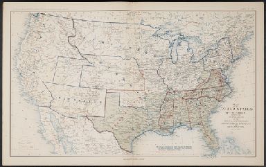
Detail View: Yale_small: Map of the United States of America, showing the boundaries of the Union and Confederate geographical divisions and departments, Dec 31, 1862
|
Published/Created Date:
|
1895
|
|
Publication Place:
|
Washington
|
|
Publisher:
|
Government Printing Office
|
|
Extent:
|
1 folded map
|
|
Call Number:
|
1979 Folio 51
|
|
Collection Title:
|
Atlas to accompany the official records of the Union and Confederate armies. Published under the direction of the Hon. Daniel S. Lamont, Secretary of War, by Maj. George B. Davis ... Mr. Leslie J. Perry, Mr. Joseph W. Kirlkey, Board of Publication. Compil
|
|
Collection Created:
|
Washington, Government Printing Office, 1895
|
|
Format:
|
cartographic
|
|
Access:
|
Public
|
|
Rights:
|
The use of this image may be subject to the copyright law of the United States (Title 17, United States Code) or to site license or other rights management terms and conditions. The person using the image is liable for any infringement.
|
|
Orbis ID:
|
3409156
|
|
OID:
|
2005511
|
|
Image OID:
|
1030362
|
|
Title:
|
Map of the United States of America, showing the boundaries of the Union and Confederate geographical divisions and departments, Dec 31, 1862
|
|
Attribution:
|
Yale University Library
|
|
Creator:
|
United States. War Dept
|
|
Genre:
|
Maps
|