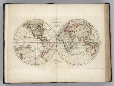
Detail View: David Rumsey Historical Map Collection: Map of the World.
|
Short Title:
|
Map of the World.
|
|
Obj Height cm:
|
28
|
|
Obj Width cm:
|
50
|
|
Scale 1:
|
80,000,000
|
|
Note:
|
Double hemisphere map in outline color. Three routes of Captain Cook shown from 1768-1771, 1772-1775, and 1776-1780. Prime meridian London. Major relief shown by sketches.
|
|
Reference:
|
P732.
|
|
Full Title:
|
A Map of the World from the best Authorities. J. Bower, Sc.
|
|
List No:
|
2721.006
|
|
Page No:
|
1
|
|
Series No:
|
6
|
|
Pub Date:
|
1818
|
|
Pub Title:
|
Carey's General Atlas, Improved And Enlarged; Being A Collection Of Maps Of The World And Quarters, Their Principal Empires, Kingdoms, &c. ... Philadelphia: Published By M. Carey And Son, 1818.
|
|
Pub Reference:
|
P732.
|
|
Pub Note:
|
Third and last edition. There is a Preface to the third edition, dated June 18, 1818.
|
|
Pub List No:
|
2721.000
|
|
Pub Maps:
|
58
|
|
Pub Height cm:
|
45
|
|
Pub Width cm:
|
31
|
|
Image No:
|
2721006
|
|
Download 1:
|
|
|
Download 2:
|
|
|
Publisher Location:
|
Philadelphia
|
|
Publisher:
|
M. Carey and Son
|
|
Type:
|
Atlas Map
|
|
World Area:
|
World
|
|
Engraver or Printer:
|
J. Bower, Sc.
|
|
Publication Author:
|
Carey, Mathew
|
|
Pub Type:
|
World Atlas
|
|
Author:
|
Carey, Mathew
|
|
Date:
|
1818
|