Detail View: David Rumsey Historical Map Collection: Second Map 1620
|
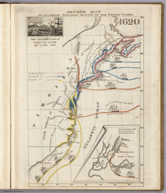
Short Title:
|
Second Map 1620
|
|
Obj Height cm:
|
28
|
|
Obj Width cm:
|
18
|
|
Scale 1:
|
None shown
|
|
Note:
|
Accompanies Willard's "History of the United States" - see our #3607. Most maps have drawing of an important historical event. Insets maps of specific areas included. Maps in outline color bound in brown paper covered boards 28x31, with title "A Series of Maps to Willard's History of the United States, Or, Republic Of America. Designed For Schools And Private Libraries. New-York: White, Gallaher & White, 108 Pearl-street. 1829. Clayton & Van Norden, Printers, 64 Pine-street."
|
|
Reference:
|
P10648.
|
|
Full Title:
|
Second Map. To Accompany Willard's History Of The United States 1620. (Inset) The Pilgrims Land at Plymouth on the 22nd. of Dec. 1620. (inset map) Places Near The Mouth of the Hudson Visited by the Dutch. Engraved & Printed by Saml. Maverick.
|
|
List No:
|
2642.004
|
|
Series No:
|
5
|
|
Pub Date:
|
1829
|
|
Pub Title:
|
A Series of Maps to Willard's History of the United States, Or, Republic Of America. Designed For Schools And Private Libraries. New-York: White, Gallaher & White, 108 Pearl-street. 1829. Clayton & Van Norden, Printers, 64 Pine-street.
|
|
Pub Reference:
|
P10648.
|
|
Pub Note:
|
Accompanies Willard's "History of the United States" - see our #3607. Most maps have drawing of an important historical event. Insets maps of specific areas included. Maps in outline color bound in brown paper covered boards with title as above.
|
|
Pub List No:
|
2642.000
|
|
Pub Maps:
|
12
|
|
Pub Height cm:
|
28
|
|
Pub Width cm:
|
23
|
|
Image No:
|
2642004
|
|
Download 1:
|
|
|
Download 2:
|
|
|
Publisher Location:
|
New York
|
|
Publisher:
|
White, Gallaher, & White
|
|
Type:
|
Atlas Map
|
|
Country:
|
United States
|
|
Subject:
|
Historical
|
|
Engraver or Printer:
|
Maverick, Saml.
|
|
Publication Author:
|
Willard, Emma
|
|
Pub Type:
|
School Atlas
|
|
Author:
|
Willard, Emma
|
|
Date:
|
1829
|