Detail View: David Rumsey Historical Map Collection: Map of the Public Surveys in California, 1857
|
Short Title:
|
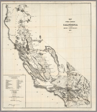
Map of the Public Surveys in California, 1857
|
|
Obj Height cm:
|
92
|
|
Obj Width cm:
|
78
|
|
Scale 1:
|
1,140,480
|
|
Note:
|
Eleven issues from the Annual Report, (1854,55,56,57,58,59,60,61,62, 63,64). Without color. Scale 18 miles to an inch. Relief shown by hachures. In upper right corner: Sen. Ex. Doc. No. 11 & Ho. Ex. Doc. No. 2, 1st Sess., 35th Cong. Shows list of private Grants finally surveyed, townships, and lands surveyed and proposed to be surveyed. Includes Explanation. (From: Report of the Commissioner of the General Land Office).
|
|
Full Title:
|
Map of the Public Surveys in California ; to Accompany Report of Surveyor Genl., 1857. Wagner & McGuigan Lith. Phila. Surveyor Generals' Office, San Francisco, California, September 30th, 1857, Approved J.W. Mandeville, U.S. Surr. Genl. Cala.
|
|
List No:
|
1073.004
|
|
Series No:
|
4
|
|
Pub Date:
|
1857
|
|
Pub Title:
|
Map of the Public Surveys in California ; to Accompany Report of Surveyor Genl., 1857. Wagner & McGuigan Lith. Phila. Surveyor Generals's Office, San Francisco, California, September 30th, 1857, Approved J.W. Mandeville, U.S. Surr. Genl. Cala.
|
|
Pub Note:
|
Eleven issues from the Annual Report, (1854,55,56,57,58,59,60,61,62, 63,64).
|
|
Pub List No:
|
1073.000
|
|
Pub Maps:
|
11
|
|
Pub Height cm:
|
92
|
|
Pub Width cm:
|
78
|
|
Image No:
|
1073004
|
|
Download 1:
|
|
|
Download 2:
|
|
|
Publisher Location:
|
Philadelphia
|
|
Publisher:
|
Wagner & McGuigan
|
|
Type:
|
Separate Map
|
|
State/Province:
|
California
|
|
Subject:
|
U.S. Public Survey
|
|
Engraver or Printer:
|
Mandeville, J.W.
|
|
Engraver or Printer:
|
California, Surveyor Generals' Office
|
|
Publication Author:
|
U.S. General Land Office
|
|
Pub Type:
|
Separate Map
|
|
Author:
|
U.S. General Land Office
|
|
Date:
|
1857
|