COLLECTION NAME:
David Rumsey Historical Map Collection
Record
Short Title:
Les Principales Forteresses Ports &c. De L'Amerique Septentrionale
Obj Height cm:
51
Obj Width cm:
61
Scale 1:
Variable
Note:
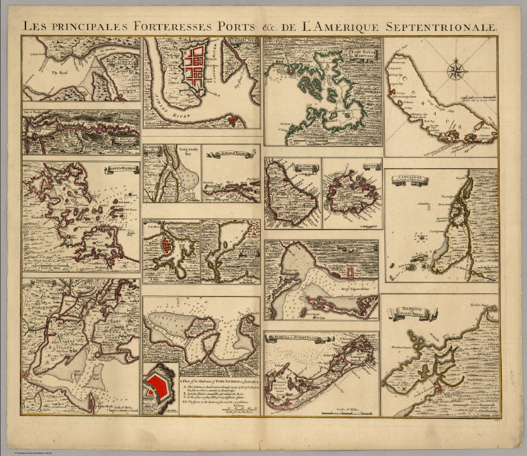
19 color maps on sheet 49 x 67. Showing major forts and ports of North America and the Caribbean area. Covens and Mortier published a seven sheet version of Henry Popple's "Map of The British Empire in America" in approximately 1737 (dated by Cumming and Wallis). It appeared in their Atlas Nouveau editions after about 1741. This is sheet six, with the Forts and Harbors. It has sixteen harbor maps, one more than Popple's fifteen harbor maps, adding the island of Curacao. Maps have outline color. The other sheets were the Key Map (almost an exact copy of Popple), fours sheets that reproduce Popple's map at half the size, and a single sheet of four views - Mexico City, New York, Quebec, and Niagara Falls. The Harbor Sheet and the Views sheets are the scarcest.
Reference:
P3448, vol 9 No. 45; Koeman C & M 7; Cumming & Wallis Introductory Notes to Margary's Popple reprint.
Full Title:
Les Principales Forteresses Ports &c. De L'Amerique Septentrionale. I.K.S.
List No:
4978.000
Series No:
1
Pub Date:
1737
Pub Title:
Les Principales Forteresses Ports &c. De L'Amerique Septentrionale. I.K.S.
Pub Reference:
P3448, vol 9 No. 45; Koeman C & M 7; Cumming & Wallis Introductory Notes to Margary's Popple reprint.
Pub Note:
Covens and Mortier published a seven sheet version of Henry Popple's "Map of The British Empire in America" in approximately 1737 (dated by Cumming and Wallis). It appeared in their Atlas Nouveau editions after about 1741. This is sheet six, with the Forts and Harbors. It has sixteen harbor maps, one more than Popple's fifteen harbor maps, adding the island of Curacao. Maps have outline color. The other sheets were the Key Map (almost an exact copy of Popple), fours sheets that reproduce Popple's map at half the size, and a single sheet of four views - Mexico City, New York, Quebec, and Niagara Falls. The Harbor Sheet and the Views sheets are the scarcest.
Pub List No:
4978.000
Pub Height cm:
51
Pub Width cm:
61
Image No:
4978000
Publisher Location:
Amsterdam
Publisher:
Covens & Mortier
Type:
Separate Map
World Area:
North America
Region:
Caribbean Area
Engraver or Printer:
I.K.S.
Publication Author:
Covens, Jean
Publication Author:
Mortier, Corneille
Publication Author:
(Popple, Henry)
Pub Type:
Separate Map
Author:
Covens, Jean
Author:
Mortier, Corneille
Author:
(Popple, Henry)
Date:
1737
Les Principales Forteresses Ports &c. De L'Amerique Septentrionale