COLLECTION NAME:
David Rumsey Historical Map Collection
Record
Short Title:
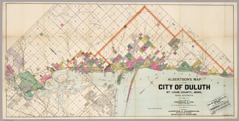
Map Of The City Of Duluth, St. Louis County, Minn.
Obj Height cm:
54
Obj Width cm:
108
Scale 1:
31,680
Note:
Attractive map showing the growth of this city. Color map Showing tract and lot numbers, rivers, roads, canals, railroads, and vegetation.
Reference:
None found.
Full Title:
Albertson's Map Of The City Of Duluth, St. Louis County, Minn., And Vicinity. Drawn and Engraved by Frederick B. Roe, Civil Engineer and Map Publisher, No. 17 North Sixth Street, Philadelphia, Pa. Published by Albertson & Chamberlain ... 323 West Superior St., Duluth, Minn. Copyright, 1891.
List No:
4296.000
Series No:
1
Pub Date:
1891
Pub Title:
Albertson's Map Of The City Of Duluth, St. Louis County, Minn., And Vicinity. Drawn and Engraved by Frederick B. Roe, Civil Engineer and Map Publisher, No. 17 North Sixth Street, Philadelphia, Pa. Published by Albertson & Chamberlain ... 323 West Superior St., Duluth, Minn. Copyright, 1891.
Pub Reference:
None found.
Pub Note:
Attractive map showing the growth of this city.
Pub List No:
4296.000
Pub Height cm:
54
Pub Width cm:
108
Image No:
4296000
Publisher Location:
Duluth
Publisher:
Albertson & Chamberlain
Type:
Separate Map
State/Province:
Minnesota
County:
Saint Louis County (Minn)
City:
Duluth
Subject:
Land Development
Publication Author:
Roe, Frederick B.
Pub Type:
Separate Map
Author:
Roe, Frederick B.
Date:
1891
Map Of The City Of Duluth, St. Louis County, Minn.