Detail View: David Rumsey Historical Map Collection: Comparative View of the Lengths of the Principal Rivers in the World.
|
Short Title:
|
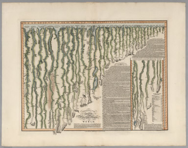
Comparative View of the Lengths of the Principal Rivers in the World.
|
|
Obj Height cm:
|
52
|
|
Obj Width cm:
|
68
|
|
Note:
|
The rivers have been necessarily straightened to indicate the lengths of the rivers. The compass orientation of the flowing stream is indicated by small north-pointing arrows periodically drawn adjacent to the stream. Includes table of the Length of Rivers in British Miles. A textual description of the rivers accompanies the illustration; it describes the course of the Missouri River, "recently explored by the Americans" (Lewis and Clark), as being "extremely devious". Beautiful color.
|
|
Full Title:
|
Comparative View of the Lengths of the Principal Rivers in the World. London, Published by C. Smith Mapseller No. 172 Strand, Oct. 1st.1817. The Hills &c. by Palmer_The Writing by Gardner.
|
|
List No:
|
6932.000
|
|
Series No:
|
1
|
|
Pub Date:
|
1817
|
|
Pub Title:
|
Comparative View of the Lengths of the Principal Rivers in the World. London, Published by C. Smith Mapseller No. 172 Strand, Oct. 1st.1817. The Hills &c. by Palmer_The Writing by Gardner.
|
|
Pub Note:
|
See Note field above.
|
|
Pub List No:
|
6932.000
|
|
Pub Maps:
|
1
|
|
Pub Height cm:
|
67
|
|
Pub Width cm:
|
85
|
|
Image No:
|
6932000
|
|
Download 1:
|
|
|
Download 2:
|
|
|
Publisher Location:
|
London
|
|
Publisher:
|
C. Smith
|
|
Type:
|
Separate Map
|
|
Type:
|
View
|
|
Subject:
|
Mountains/Rivers
|
|
Subject:
|
Rivers
|
|
Engraver or Printer:
|
Palmer
|
|
Engraver or Printer:
|
Gardner
|
|
Publication Author:
|
Smith, C.
|
|
Pub Type:
|
Separate Map
|
|
Pub Type:
|
View
|
|
Author:
|
Smith, C.
|
|
Date:
|
1817
|