Detail View: David Rumsey Historical Map Collection: Index Map: Key System Transit Lines: Aerial System Maps.
|
Short Title:
|
Index Map: Key System Transit Lines: Aerial System Maps.
|
|
Obj Height cm:
|
49
|
|
Obj Width cm:
|
40
|
|
Note:
|
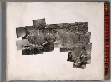
Sunderland Reference A17842B. Photographs missing tabs labeled on back in pencil. Air photo mosaic serving as an index to the air photos in volume.
|
|
Reference:
|
Atlas obtained from the Institute of Transportation Studies Library (Harmer E. Davis Transportation Library) at the University of California, Berkeley.
|
|
Full Title:
|
(Index Map to) Key System Transit Lines: Aerial System Maps.
|
|
List No:
|
6346.002
|
|
Page No:
|
Index A
|
|
Series No:
|
2
|
|
Pub Date:
|
1947
|
|
Pub Title:
|
Key System Transit Lines: Aerial System Maps.
|
|
Pub Reference:
|
Atlas obtained from the Institute of Transportation Studies Library (Harmer E. Davis Transportation Library) at the University of California, Berkeley.
|
|
Pub Note:
|
Large volume of bound aerial photographs with colored tape showing the Key System train, tram, and bus routes. (Formerly) Restricted. Two index sheets and 62 enlargements of western Alameda and Contra Costa Counties. Black and white.
|
|
Pub List No:
|
6346.000
|
|
Pub Maps:
|
64
|
|
Pub Height cm:
|
56
|
|
Pub Width cm:
|
43
|
|
Image No:
|
6346002
|
|
Download 1:
|
|
|
Download 2:
|
|
|
Publisher Location:
|
Oakland
|
|
Publisher:
|
Clyde H. Sunderland Photographs
|
|
Type:
|
Index Page
|
|
Type:
|
Aerial Photographs
|
|
County:
|
Alameda County (Calif.)
|
|
County:
|
Contra Costa County (Calif.)
|
|
Region:
|
East Bay Area (Calif.)
|
|
Subject:
|
Transportation
|
|
Publication Author:
|
Key System Transit Lines (Calif.)
|
|
Publication Author:
|
Sunderland, Clyde H.
|
|
Pub Type:
|
Aerial Photographs
|
|
Pub Type:
|
Regional Atlas
|
|
Author:
|
Key System Transit Lines (Calif.)
|
|
Author:
|
Sunderland, Clyde H.
|
|
Date:
|
1947
|