Detail View: David Rumsey Historical Map Collection: Cours du Mississippi comprenant la Louisiane
|
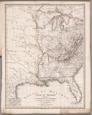
Short Title:
|
Cours du Mississippi comprenant la Louisiane
|
|
Obj Height cm:
|
55
|
|
Obj Width cm:
|
42
|
|
Scale 1:
|
5,068,800
|
|
Note:
|
Engraved hand color outline map. One of the largest printed maps of French Louisiana. . Shows Mississippi River to Florida. The lower Missouri and the Kansas are well delineated. Includes Indian details, forts, etc. Relief shown by hachures and pictorially. Prime meridians are Paris and Ferro.
|
|
Reference:
|
Wheat 257; Lowery 741.
|
|
Full Title:
|
Cours du Mississippi comprenant la Louisiane, les 2 Florides, une partie des Etats-Unis et pays adjacents. Par J. B. Poirson, ingenieur geographe ; Nivose An XI (1803), grave par Tardieu l'aine rue de Sorbonne, no. 385. (on upper right margin) No.XVIII. (to accompany) Statistique Generale et Particuliere De La France et De Ses Colonies, avec une Nouvelle Description ... 1804.
|
|
List No:
|
4003.023
|
|
Page No:
|
XVIII
|
|
Series No:
|
23
|
|
Pub Date:
|
1804
|
|
Pub Title:
|
Statistique Generale et Particuliere De La France et De Ses Colonies, avec une Nouvelle Description ... Sept Volumes ... 9 Grandes Cartes ... par J.B. Poirson ... Collection de Table et Cartes. A Paris, Chez F. Buisson ... 1804. (Atlas only).
|
|
Pub Reference:
|
Wheat 257; Lowery 741.
|
|
Pub Note:
|
The important map in this book is Poirson's "Cours De Mississippi Comprenant La Louisiane, Les 2 Florides, Une Partie Des Etas-Unis, et Pays Adjacents." One of the last French maps of Louisiana before it was transferred to the United States. Wheat calls the map "of great interest" in its "display (of) the concept of Louisiana, and especially Missouri, current in French official circles just before the transfer of the Province to the United States." The remainder of the maps, all of which are in outline color, show French holdings throughout the world. Bound with half leather boards, the title on the spine.
|
|
Pub List No:
|
4003.000
|
|
Pub Maps:
|
9
|
|
Pub Height cm:
|
29
|
|
Pub Width cm:
|
23
|
|
Image No:
|
4003023
|
|
Download 1:
|
|
|
Download 2:
|
|
|
Publisher Location:
|
Paris
|
|
Publisher:
|
F. Buisson
|
|
Type:
|
Book Map
|
|
Country:
|
United States
|
|
Region:
|
Mississippi River
|
|
Engraver or Printer:
|
Tardieu, B.
|
|
Engraver or Printer:
|
Perrier
|
|
Engraver or Printer:
|
Giraldon
|
|
Publication Author:
|
Poirson, J.B.
|
|
Publication Author:
|
Herbin de Halle, Etienne de.
|
|
Pub Type:
|
Geography Book
|
|
Author:
|
Poirson, J.B.
|
|
Author:
|
Herbin de Halle, Etienne de.
|
|
Date:
|
1803
|