Detail View: David Rumsey Historical Map Collection: An Historical Chart representing ... of the principal Empires of the World
|
Short Title:
|
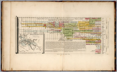
An Historical Chart representing ... of the principal Empires of the World
|
|
Obj Height cm:
|
22
|
|
Obj Width cm:
|
40
|
|
Note:
|
Detailed full color chart showing the history of the Empires from 2300 B.C. to 1800 A.D. Chart includes explanation and note. Map is hand colored, includes note. Relief shown by hachures.
|
|
Reference:
|
Walsh p. 173
|
|
Full Title:
|
An Historical chart representing in a chronological series the rife revolutions & fall of the principal empire of the World ... Engraved for Mayo's Ancient Geography & History. J. Vallace, Sc.(with map of) Roman Empire &c. Tyrus. (to accompany) An Atlas Of Ten Select Maps Of Ancient Geography Both Sacred And Profane; With A Chronological Table Of Universal History & Biography.
|
|
List No:
|
0497.012
|
|
Series No:
|
12
|
|
Pub Date:
|
1815
|
|
Pub Title:
|
An Atlas Of Ten Select Maps Of Ancient Geography Both Sacred And Profane; With A Chronological Table Of Universal History & Biography. Being Intended As An Accompaniment To Mayo's Ancient Geography And History. Calculated For The Use Of Seminaries, &c. Philadelphia: Published By John Mellish (sic), No. 49 South Third Street, And Sold By The Principal Booksellers In The United States. 1815.
|
|
Pub Reference:
|
Walsh p. 173
|
|
Pub Note:
|
Maps copied from Wilkinson's Atlas Classica. This becomes the Finley Ancient Atlas. Lucas also used many of these maps in his General Atlas of 1823. Covers are half leather, marbled paper covered boards.
|
|
Pub List No:
|
0497.000
|
|
Pub Maps:
|
9
|
|
Pub Height cm:
|
38
|
|
Pub Width cm:
|
29
|
|
Image No:
|
0497012
|
|
Download 1:
|
|
|
Download 2:
|
|
|
Publisher Location:
|
Philadelphia
|
|
Publisher:
|
John Mellish
|
|
Type:
|
Timeline
|
|
Subject:
|
Historical
|
|
Engraver or Printer:
|
Tanner, H.S.
|
|
Engraver or Printer:
|
Vallance, J.
|
|
Engraver or Printer:
|
Mayo, Robert
|
|
Engraver or Printer:
|
Thackara, J.
|
|
Publication Author:
|
Mellish, John
|
|
Pub Type:
|
Classical Atlas
|
|
Author:
|
Mellish, John
|
|
Date:
|
1815
|