COLLECTION NAME:
David Rumsey Historical Map Collection
Record
Short Title:
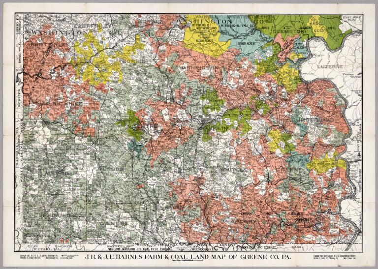
J.R. & J.E. Barnes Farm & Coal Land Map of Greene County, Pennsylvania.
Obj Height cm:
23
Obj Width cm:
105
Scale 1:
50,000
Note:
Unusual coal map showing ownership of coal fields, location and depth of coal seems, proposed tunnels to mine the coal and all the usual surface information on towns, roads, rivers, etc. Mounted on linen. Full color.
Full Title:
J.R. & J.E. Barnes Farm & Coal Land Map of Greene Co. Pa. ... Compiled from Coal Surveys & U.S. Topographical Sheets, Richard L. Smith C.E., Pittsburg Pa. Wm. E. Doak Del.
List No:
3759.002
Series No:
2
Pub Date:
1907
Pub Title:
J.R. & J.E. Barnes Farm & Coal Land Map of Greene Co. Pa. ... Compiled from Coal Surveys & U.S. Topographical Sheets, Richard L. Smith C.E., Pittsburg Pa. Wm. E. Doak Del.
Pub Note:
See Note field.
Pub List No:
3759.000
Pub Maps:
1
Pub Height cm:
23
Pub Width cm:
15
Image No:
3759.002
Publisher Location:
Washington D.C.
Publisher:
Andrew B. Graham Company Lithographers
Type:
Case Map
County:
Green County (Pa.)
Subject:
Property Ownership
Subject:
Mining and Minerals
Engraver or Printer:
Wm. E. Doak
Publication Author:
Barnes, J.R.
Publication Author:
Barnes, J.E.
Publication Author:
Smith, Richard L.
Pub Type:
Case Map
Author:
Barnes, J.R.
Author:
Barnes, J.E.
Author:
Smith, Richard L.
Date:
1907
J.R. & J.E. Barnes Farm & Coal Land Map of Greene County, Pennsylvania.