Detail View: David Rumsey Historical Map Collection: Chart of the World.
|
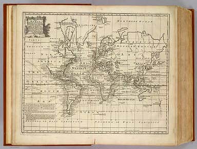
Short Title:
|
Chart of the World.
|
|
Obj Height cm:
|
36
|
|
Obj Width cm:
|
45
|
|
Scale 1:
|
95,000,000
|
|
Note:
|
Engraved map. Includes note on lines of magnetic declination, and dates of European discoveries.
|
|
Reference:
|
cf P614 (1752 edition of A Complete Atlas...); NMM p.356; M&B p 166.
|
|
Full Title:
|
A new & accurate chart of the world. Drawn from authentic surveys, assisted by the most approved modern maps & charts & regulated by astronl. observations, whereon are described lines, shewing the variation of the magnetical needle, according to observations made by several experienced navigators about the year 1744. By Eman: Bowen, Geographer to His Majesty. (London: Printed for William Innys, Richard Ware, Aaron Ward, J. and P. Knapton, John Clarke, T. Longman and T. Shewell, Thomas Osborne, Henry Whitridge ... M.DCC.XLVII)
|
|
List No:
|
3733.003
|
|
Page No:
|
No. 3
|
|
Series No:
|
5
|
|
Pub Date:
|
1747
|
|
Pub Title:
|
A complete system of geography. Being a description of all the countries, islands, cities, chief towns, harbours, lakes, and rivers, mountains, mines, &c. of the known world ... In two volumes. The whole illustrated with seventy maps, by Emanuel Bowen, Geographer to His Majesty, being all new-drawn and ingraved according to the latest discoveries and surveys; making, of themselves, a complete atlas, for the sse of gentlemen, merchants, mariners, and others, who delight in history and geography ... Vol. 1. London: Printed for William Innys, Richard Ware, Aaron Ward, J. and P. Knapton, John Clarke, T. Longman and T. Shewell, Thomas Osborne, Henry Whitridge ... M.DCC.XLVII.
|
|
Pub Reference:
|
cf P614 (1752 edition of A Complete Atlas...); NMM p.356; M&B p 166.
|
|
Pub Note:
|
In the title Bowen states that he is "Preserving all that is useful in the Fourth and Last edition of the Complete Geographer, publish'd under the name of Herman Moll, &c." The 70 maps were also published in two other forms: in "A Complete Atlas" of 1752, and as the Maps for the "Complete Collection of Voyages" by John Harris, in 1744-48 (M&B). The text is massive and interesting, and there are several important maps of America: America, West Indies, Mexico, Louisiana, Carolina, Virginia, Pennsylvania et al, and Newfoundland et al. The map of the World in Hemispheres is lacking in this copy. Both volumes are newly bound in full brown leather covered boards with "Geography. Vol. 1" and -Geography. Vol. 2" embossed on the spine in gilt.
|
|
Pub List No:
|
3733.000
|
|
Pub Maps:
|
70
|
|
Pub Height cm:
|
43
|
|
Pub Width cm:
|
28
|
|
Image No:
|
3733003
|
|
Institution:
|
Rumsey Collection
|
|
Ownership Statement:
|
Copyright 2000
|
|
Download 1:
|
|
|
Download 2:
|
|
|
Publisher Location:
|
London
|
|
Publisher:
|
William Innys [et al.]
|
|
Type:
|
Atlas Map
|
|
Type:
|
Chart Map
|
|
World Area:
|
World
|
|
Publication Author:
|
Bowen, Emanuel
|
|
Pub Type:
|
Geography Book
|
|
Author:
|
Bowen, Emanuel
|
|
Date:
|
1747
|