Detail View: David Rumsey Historical Map Collection: The "Time & Tide" Map of The Atlantic Charter.
|
Short Title:
|
The "Time & Tide" Map of The Atlantic Charter.
|
|
Obj Height cm:
|
82
|
|
Obj Width cm:
|
111
|
|
Note:
|
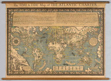
At the head of the map is a lengthy quote from the Atlantic Charter, with the signatures of Franklin Roosevelt and Winston Churchill. The Atlantic Charter was a pivotal policy statement issued in August 1941 that, early in World War II, defined the Allied goals for the post-war world. It was drafted by the leaders of Britain and the United States, and later agreed to by all the Allies. Dramatic graphics with vignettes representative of various crops and resources. Statements espousing peace.
|
|
Full Title:
|
The "Time & Tide" Map of The Atlantic Charter.
|
|
List No:
|
7864.000
|
|
Series No:
|
1
|
|
Pub Date:
|
1942
|
|
Pub Title:
|
The "Time & Tide" Map of The Atlantic Charter.
|
|
Pub Note:
|
Mounted on linen. Wooden sticks at top and bottom. Denoyer-Geppert Company sole distributor in the United States. Leslie MacDonald Gill was a noted and prolific graphic designer, cartographer, artist and architect.
|
|
Pub List No:
|
7864.000
|
|
Pub Maps:
|
1
|
|
Pub Height cm:
|
82
|
|
Pub Width cm:
|
111
|
|
Image No:
|
7864000
|
|
Download 1:
|
|
|
Download 2:
|
|
|
Publisher Location:
|
London
|
|
Publisher:
|
The London Geographical Institute
|
|
Type:
|
Wall Map
|
|
World Area:
|
World
|
|
Subject:
|
Agriculture
|
|
Subject:
|
Pictorial map
|
|
Engraver or Printer:
|
George Philip & Son, Ltd.
|
|
Publication Author:
|
Gill, Leslie MacDonald, 1884-1947
|
|
Pub Type:
|
Wall Map
|
|
Author:
|
Gill, Leslie MacDonald, 1884-1947
|
|
Date:
|
1942
|