COLLECTION NAME:
David Rumsey Historical Map Collection
Record
Short Title:
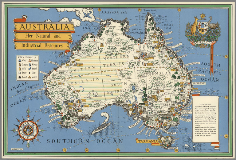
Australia: her natural and industrial resources
Obj Height cm:
49
Obj Width cm:
74
Scale 1:
8,944,941
Note:
A decorative pictorial map of Australia. Relief shown pictorially. This map poster was one of a series designed by Gill in 1942 showing Britain's imperial allies. Map illustrating the locations of various industrial and natural resource, such as farmland, mines and forests. Includes Australia's coat of arms, a compass and Key to symbols. Map has various texts. As noted in the text: "In War and Peace: Australia's industrial resources have been completely reorganised to meet war-time demands ... In addition, Australia is contributing to a great wheat pool which will help to feed the starving peoples of Europe when the war is over".
Full Title:
Australia: her natural and industrial resources. [Drawn by] MacDonald Gill, 1943. Printed in England by Alf Cooke, Ltd., Leeds and London. 51-9871.
List No:
8564.000
Pub Date:
1942
Pub Title:
Australia: her natural and industrial resources. [Drawn by] MacDonald Gill, 1943. Printed in England by Alf Cooke, Ltd., Leeds and London. 51-9871.
Pub Note:
See note field above.
Pub List No:
8564.000
Pub Height cm:
49
Pub Width cm:
74
Image No:
8564000
Publisher Location:
London and Leeds, England
Publisher:
Alf Cooke, Ltd.
Type:
Separate Map
Country:
Australia
Subject:
Pictorial map
Publication Author:
Gill, Leslie MacDonald, 1884-1947
Pub Type:
Separate Map
Author:
Gill, Leslie MacDonald, 1884-1947
Date:
1942
Australia: her natural and industrial resources