COLLECTION NAME:
David Rumsey Historical Map Collection
Record
Short Title:
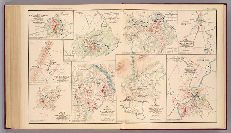
Hanging Rock; Monocacy.
Obj Height cm:
43
Obj Width cm:
70
Scale 1:
Various
Note:
Two col. maps, with 7 ancillary maps. Relief shown by hachures.
Full Title:
No. 10. Map of engagement at Hanging Rock, Roanoke County, Va., Tuesday, June 21st, 1864. No. 15. Sketch of the battle Monocacy, Frederick Co., Md., Saturday July 9th 1864. (with) No. 2. Sketch of the battle of the Wilderness. Position of 2d Corps. A.N. Va., Thursday May 5th 1864. (with) No. 3. Sketch of the battle of the Wilderness. Position of 2d Corps, A.N. Va., Friday May 6th 1864. (with) No. 4. Sketch showing positions and entrenchments of the 2d Corps, A.N. Va., during the battles of Spotsylvania C.H., Va. from May 9th to May 21st 1864. (with) No. 14. Map of action of McCausland's cavalry brigade at Hagerstown, Md., Thursday July 7th 1864. (with) No. 13. Map of the capture of North Mountain Depot, Va. by McCausland's cavalry brigade, Monday July 4th 1864. (with) No. 16. Sketch of the battle of Rutherford's Farm, Va., July 20th 1864. (with) No. 9. Map of engagement near Lynchburg, Va., Saturday June 18th 1864, from Maj. A.H. Campbell's surveys. (all) To accompany report of Jed. Hotchkiss, Top. Eng. ... Julius Bien & Co., Lith., N.Y. (1891-1895)
List No:
1780.083
Page No:
pl. LXXXIII
Series No:
87
Pub Date:
1895
Pub Title:
Atlas to accompany the official records of the Union and Confederate armies. Published under the direction of the Hons. Redfield Proctor, Stephen B. Elkins and Daniel S. Lamont, secretaries of war, by Maj. George B. Davis, U.S. Army, Mr. Leslie J. Perry, civilian expert, Mr. Joseph W. Kirkley, civilian expert, Board of Publication. Compiled by Capt. Calvin D. Cowles, 23d U.S. Infantry. Washington: Government Printing Office, 1891-1895.
Pub Reference:
LC Civil War maps (2nd ed.), 99; Civil War maps in the National Archives, 8; Phillips, 1353; LeGear. Atlases of the United States, 266.
Pub Note:
See note field above.
Pub List No:
1780.000
Pub Maps:
158
Pub Height cm:
47
Pub Width cm:
40
Image No:
1780083
Institution:
Rumsey Collection
Ownership Statement:
Copyright 2005
Event:
U.S. Civil War
Publisher Location:
Washington
Publisher:
U.S. Government Printing Office
Type:
Atlas Map
State/Province:
Maryland
State/Province:
Virginia
County:
Frederick County (Md.)
County:
Roanoke County (Va.)
City:
Hagerstown (Md.)
City:
Lynchburg (Va.)
Subject:
Military
Engraver or Printer:
Campbell, Albert H.
Engraver or Printer:
Julius Bien & Co.
Publication Author:
Cowles, Calvin D.
Publication Author:
Davis, George B.
Publication Author:
Kirkley, JAW.
Publication Author:
Perry, Leslie J.
Publication Author:
United States. War Department
Pub Type:
Military Atlas
Author:
Confederate States of America. Army of Northern Virginia
Author:
Confederate States of America. Army
Author:
Hotchkiss, Jed.
Date:
1895
Hanging Rock; Monocacy.