Detail View: David Rumsey Historical Map Collection: India 5.
|
Short Title:
|
India 5.
|
|
Obj Height cm:
|
40
|
|
Obj Width cm:
|
34
|
|
Scale 1:
|
2,217,600
|
|
Note:
|
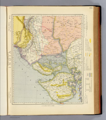
Colored map. Relief shown by hachures and spot heights. Shows cities, political divisions, European possessions, telegraph lines, roads, railroads, coffee plantations, forests, lights and lighthouses, etc. Covers Gujarat, Cutch, Khyerpoor, Kurache, Jeysulmair, Marwar, etc.
|
|
Full Title:
|
Statistical & general map of India. No. 5. Letts's popular atlas. Letts, Son & Co. Limited, London. (1883)
|
|
List No:
|
5371.086
|
|
Page No:
|
89
|
|
Series No:
|
91
|
|
Pub Date:
|
1883
|
|
Pub Title:
|
Letts's popular atlas, being a series of maps delineating the whole surface of the globe, with many special and original features; and a copious index of 23,000 names. Complete edition. Letts, Son & Co. Limited, 33, King William Street, London Bridge, E.C. Factory and works at New Cross, S.E. 1883.
|
|
Pub Reference:
|
Cf P900 and World 435 (4 v. in 2, 1881-1883)
|
|
Pub List No:
|
5371.000
|
|
Pub Maps:
|
153
|
|
Pub Height cm:
|
45
|
|
Pub Width cm:
|
38
|
|
Image No:
|
5371086
|
|
Institution:
|
Rumsey Collection
|
|
Ownership Statement:
|
Copyright 2006
|
|
Download 1:
|
|
|
Download 2:
|
|
|
Publisher Location:
|
London
|
|
Publisher:
|
Letts, Son & Co.
|
|
Type:
|
Atlas Map
|
|
Country:
|
India
|
|
Country:
|
Pakistan
|
|
Publication Author:
|
Letts, Son & Co.
|
|
Pub Type:
|
World Atlas
|
|
Author:
|
Letts, Son & Co.
|
|
Date:
|
1883
|