Browse All

1958 Index: World Air Routes, Plate 7, v.1 World Atlas (Index to) World Air Routes. Bartholomew … |

1958 World Air Routes, Plate 7, v.1 World Atlas World Air Routes. 'Nordic Projection' By … |

1944 The Air Age World Atlas The Air Age. (to accompany) Atlas Of Glo … |

1953 World. Air Communications. Air Map. World Atlas World. Air Communications. World. Air Ma … |

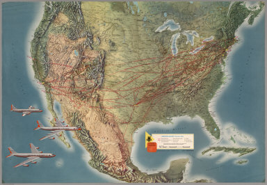
1929 Air Route from Los Angeles to Columbus. Pocket Map (Map of the United States showing the ai … |

1929 Illustrated Map of the Route of Transcon … Pocket Map Illustrated Map of the Route of Transcon … |

1942 Northern Hemisphere --Polar View Wall Map Rand McNally World Map for the Air Age. |
1962 American Airlines System Map. Separate Map American Airlines System Map. |

1968 Air Atlas - United Air Lines. United Sys … Separate Map Air Atlas - United Air Lines. United Sys … |

1967 Hawaiian Islands. Separate Map Hawaiian Islands. |

1965 TTA, Trans Texas Airways System Map. Separate Map TTA, Trans Texas Airways System Map. |

1965 Text Page: See the Great Southwest ... v … Separate Map (Text Page) See the Great Southwest ... … |

1965 American Airlines System Map. Separate Map American Airlines System Map. |

1965 Text: Welcome Aboard. Separate Map (Text Page) Welcome Aboard. |

1960 Airline Map of the United States, 1960. Separate Map Airline Map of the United States, 1960. |

1962 Airline Map of Central America and South … Separate Map Airline Map of Central America and South … |

1966 Bus and Air Transport. National Atlas Bus and Air Transport. |

1956 Pan American World Airways System Separate Map Pan American World Airways System : worl … |

1945 American Airlines system map. Pocket Map American Airlines system map. Route of t … |

1945 Verso: American Airlines system map. Pocket Map (Verso of) American Airlines system map. … |

1948 KLM Royal Dutch Airlines. Separate Map KLM Royal Dutch Airlines. 1919 - 30th Ye … |

1961 Air France, Le Plus Grand Reseau ou Mond … Separate Map Air France, Le Plus Grand Reseau ou Mond … |

1948 Air France. Reseau Aerien Postal. Separate Map Air France. Reseau Aerien Postal. Printe … |

1930 A Map of Air Mail & Passenger Routes in … Separate Map A Map of Air Mail & Passenger Routes. Pr … |

1930 World Flight Routes (all in Japanese). [Games, Separate Map] World Flight Routes (all in Japanese). |

1959 Air France, Le Plus Grand Reseau ou Mond … Separate Map Air France, Le Plus Grand Reseau ou Mond … |

1939 Air France, "Nova Et Vetera" Sur La Viei … Separate Map Air France, "Nova Et Vetera" Sur La Viei … |

1937 Air France, Reseau Aerien Mondial. Separate Map Air France, Air France, Reseau Aerien Mo … |

1938 Air France, Reseau Aerien Mondial. Separate Map Air France, Air France, Reseau Aerien Mo … |

1947 Air France, Reseau Aerien Mondial. Separate Map Air France, Air France, Reseau Aerien Mo … |

1947 Air France, Reseau Aerien Mondial. Separate Map Air France, Air France, Reseau Aerien Mo … |

1948 Air France, Reseau Aerien Mondial. Separate Map Air France, Air France, Reseau Aerien Mo … |

1950 World Air Transportation, Principal Rout … Separate Map World Air Transportation, Principal Rout … |

1953 United States Air Transportation System. Separate Map United States Air Transportation System, … |

1961 Airline Map of the United States 1961. Separate Map Airline Map of the United States 1961. C … |

1951 Routes of Pan American World Airways Sys … Separate Map Routes of Pan American World Airways Sys … |

1940 Cover: Global map. Globe (Covers to) The Global Map. Pat. No. D13 … |

1940 The Global Map. Globe The Global Map. Pat. No. D136173, Other … |

1940 (Verso of) The Global Map. Globe (Verso of) The Global Map. Pat. No. D136 … |

1967 Air Communications. Telecommunications, … World Atlas Air Communications. Telecommunications, … |

1948 Air Age Map of the World. World Atlas Air Age Map of the World. Azimuthal equi … |

1948 Arctic Ocean. Antarctica. Pacific Ocean. World Atlas Arctic Ocean. 9471. Antarctica. Pacific … |

1948 United States and Contiguous Territories … World Atlas United States Federal Reserve Districts. … |