Browse All

1875 Ohio. County Atlas New Map of Ohio Prepared Especially for … |

1875 Township of Stokes, Logan County, Ohio. County Atlas Map of the Township of Stokes, Parts of … |

1875 Bloomfield Township, Logan County, Ohio. County Atlas Map of Bloomfield Township, Parts of T.2 … |

1875 Miami Township, Logan County, Ohio. View … County Atlas Map of Miami Township, T. III. R. XIII. … |

1875 Pleasant Township, Logan County, Ohio. County Atlas Map of Pleasant Township. Compiled by M. … |

1875 Richland Township, Logan County, Ohio. County Atlas Map of Richland Township. Mapped and Com … |

1875 McArthur Township, Logan County, Ohio. County Atlas Map of McArthur Township. Compiled & Map … |

1875 Union Township, Logan County, Ohio. County Atlas Map of Union Township. Compiled by M. Gr … |

1875 Harrison Township, Logan County, Ohio. County Atlas Map of Harrison Township. |

1875 Jefferson Township, Logan County, Ohio. County Atlas Map of Jefferson Township. |

1875 Perry Township. (Portraits) Mr. and Mrs. … County Atlas Map of Perry Township, Logan County, Ohi … |

1875 Perry Township, Logan County, Ohio. (Por … County Atlas Map of Perry Township. Wm. M. Fisk. (Por … |

1875 Lake Township, Logan County, Ohio. Prope … County Atlas Map of Lake Township. Mapped by O.E. Wae … |

1875 Monroe Township, Logan County, Ohio. County Atlas Map of Monroe Township. |

1875 Zane Township, Logan County, Ohio. County Atlas Map of Zane Township. |

1875 Bokes Creek Township, Logan County, Ohio … County Atlas Map of Bokes Creek Township. Mapped and … |

1875 Rush Creek Township, Logan County, Ohio. County Atlas Map of Rush Creek Township. |

1875 Huntsville, Richland, Zanesfield, and De … County Atlas Huntsville, Oliver F. Waegon. Richland, … |

1875 Bellefontaine, Logan County, Ohio. County Atlas Map of Bellefontaine, Logan Co. Compiled … |

1875 West Liberty, Logan County, Ohio. 1874. County Atlas West Liberty. 1874. Oliver F. Waegon C.E … |
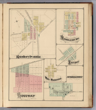
1875 Rushsylvania, Ridgeway, Middleburg, Harp … County Atlas Rushsylvania. Ridgeway, Oliver F. Waegon … |

1875 Last Liberty. Logansville. Northwood. Ch … County Atlas Last Liberty. Logansville. Northwood. Ch … |

1875 Washington Township, Logan County, Ohio. … County Atlas Map of Washington Township. (View) M.E. … |

1875 Counties of St. John & Kings, New Brunsw … County Atlas Plan of the Counties of St. John & Kings … |
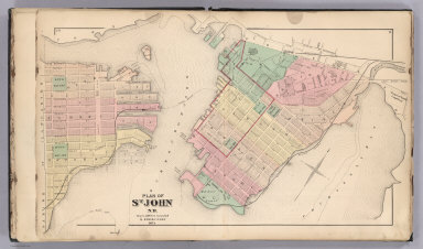
1875 St. John, N.B. (New Brunswick). County Atlas Plan of St. John, N.B. by Roe & Colby. ! … |

1875 St. John: Dukes & Sydney Wards. (New Bru … County Atlas Plan of St. John, Dukes & Sydney Wards. … |

1875 Plan of St. John, Queens Ward. (New Brun … County Atlas Plan of St. John, Queens Ward. (New Brun … |

1875 St. John: Kings Ward. (New Brunswick). County Atlas Plans of St. John, Kings Ward. (New Brun … |

1875 St. John: Wellington & Prince Wards. (Ne … County Atlas Plans of St. John, Wellington & Prince W … |

1875 St. John: Brooks Ward, Carleton. (New Br … County Atlas Plans of St. John, Brooks Ward, Carleton … |

1875 St. John: Guys & Albert Wards, Carleton. … County Atlas Plans of St. John, Guys & Albert Wards, … |

1875 Composite: St. John City. (New Brunswick … County Atlas (Composite of) St. John City. (New Bruns … |

1875 Portland (New Brunswick). County Atlas Town of Portland. (New Brunswick). |

1875 Portland, Village Plan No. 1. (New Bruns … County Atlas Portland, Village Plan No. 1. (New Bruns … |

1875 Portland, Village Plan No. 2. (New Bruns … County Atlas Portland, Village Plan No. 2. (New Bruns … |

1875 Portland, Village Plan No. 3. (New Bruns … County Atlas Portland, Village Plan No. 3. (New Bruns … |

1875 Portland, Village Plan No. 4. (New Bruns … County Atlas Portland, Village Plan No. 4. (New Bruns … |

1875 Parish of Lancaster. (New Brunswick). County Atlas Parish of Lancaster. (New Brunswick). |

1875 Part of the Parish of Lancaster No. 1. ( … County Atlas Part of the Parish of Lancaster No. 1. ( … |

1875 Part of the Parish of Lancaster No. 2. ( … County Atlas Part of the Parish of Lancaster No. 2. ( … |

1875 Fairville. (New Brunswick). County Atlas Fairville. (New Brunswick). |

1875 Musquash. (New Brunswick). County Atlas Musquash. (New Brunswick). |

1875 South Bay. (New Brunswick). County Atlas South Bay. (New Brunswick). |

1875 Parish of Simonds. (New Brunswick). County Atlas Parish of Simonds. (New Brunswick). |

1875 Part of Simonds including Crouchville, C … County Atlas Part of Simonds including Crouchville, C … |

1875 Parish of St. Martins. (New Brunswick). County Atlas Parish of St. Martins. (New Brunswick). |

1875 Quaco. (New Brunswick). County Atlas Quaco. (New Brunswick). |

1875 Township 52 North, Range 2 East, Pike Co … County Atlas Township 52 North, Range 2 East. Paynesv … |

1875 Township 52 North, Range 1 East, Pike Co … County Atlas Township 52 North, Range 1 East. |

1875 Township 52 & 53 North, Range 1 East of … County Atlas Township 52 & 53 North, Range 1 East of … |