Who What Where WhenWHO
|
Full Title
Railroad map of the United States, showing the through lines of communication from the Atlantic to the Pacific, together with the various steamship lines along the seaboard. Copyright 1886 by Wm. M. Bradley & Bro. (1890)
Publisher
John Y. Huber & Co.
Author
[Bartholomew, J. G. (John George), 1860-1920, John Bartholomew and Son]
Full Title
World - commerce. Commercial development. (with) Occupations. (with) Means of traffic. The Edinburgh Geographical Institute, John Bartholomew & Son, Ltd. "The Times" atlas. (London: The Times, 1922)
Publisher
The Times
Full Title
British Empire, showing the commercial routes of the World and ocean currents. (with) Steam-ship lines of Central America & the West Indies. (with) Steam-ship lines from ports of Western Europe. (with) Eastern steam-ship lines (Mediterranean and Black Seas. Published at the office of "The Times," London, 1895)
Publisher
The Times
Author
[Bartholomew, J. G. (John George), 1860-1920, John Bartholomew and Son]
Full Title
Western Europe - communications. The Edinburgh Geographical Institute, John Bartholomew & Son, Ltd. "The Times" atlas. (London: The Times, 1922)
Publisher
The Times
Author
[Bartholomew, J. G. (John George), 1860-1920, John Bartholomew and Son]
Full Title
Eastern Europe - communications. The Edinburgh Geographical Institute, John Bartholomew & Son, Ltd. "The Times" atlas. (London: The Times, 1922)
Publisher
The Times
Full Title
Karte des Weltverkehrs und der Meeresstromungen in Mercators Projektion. (with) Schematisches Profil einiger Haupt-Berggipfel der Erde. (Richard Andree. Herausgegeben von der Geographischen Anstalt von Velhagen & Klasing in Leipzig. 1881)
Publisher
Velhagen & Klasing
Author
[Mitchell, Samuel Augustus, Williams, W. (Wellington)]
Full Title
Map of Asia showing its gt. political divisions, and also the various routes of travel between London & India, China & Japan &c. Constructed & engraved by W. Williams, Phila. Entered ... 1870 by S. Augustus Mitchell, Jr. ... Pennsylvania.
Publisher
[R.A. Campbell, S.A. Mitchell, Jr.]
Author
[United States Army Service Forces, Office of the Geographer, Department of State]
Full Title
Iron and Steel Trade, 1937, 20.
Publisher
United States Army Service Forces
Author
[United States Army Service Forces, American Geographical Society]
Full Title
Overseas Shipping Routes 24.
Publisher
United States Army Service Forces
Author
Johnston, Alexander Keith, 1804-1871
Full Title
Physical chart of the Atlantic Ocean showing the form & direction of the currents; distribution of heat at the surface, navigation & trade routes, banks, rocks &c. by A.K. Johnston, F.R.S.E. Engraved by W. & A.K. Johnston. William Blackwood & Sons, Edinburgh & London. (1856)
Publisher
William Blackwood & Sons
Author
Johnston, Alexander Keith, 1804-1871
Full Title
Physical chart of the Indian Ocean showing the temperature of the water, the currents of the air and ocean, directions of the wind, districts of hurricanes, regions of the monsoons & ty-foons, trade routes &c. &c. By A.K. Johnston, F.R.S.E. Engraved by W. & A.K. Johnston. William Blackwood & Sons, Edinburgh & London. (1856)
Publisher
William Blackwood & Sons
Author
Johnston, Alexander Keith, 1804-1871
Full Title
Physical chart of the Pacific Ocean or Great Sea, Mare Pacifico. Showing the currents & temperature of the ocean, the trade routes &c. Founded on the observations which have been made from the time of Magalhaen to the Prussian navigators. With additions & corrections to 1855. By A.K. Johnston, F.R.S.E. Engraved by W. & A.K. Johnston. William Blackwood & Sons, Edinburgh & London. (1856)
Publisher
William Blackwood & Sons
Author
[Delarochette, Louis Stanislas d'Arcy, Faden, William, 1750?-1836]
Full Title
A chart of the islands of Jersey and Guernsey, Sark, Herm and Alderney; with the adjacent coast of France. By L.S. De la Rochette. MDCCLXXXI. London: engraved & published as the Act directs Jany. 1st, 1781 by W. Faden, successor to the late T. Jefferys, Geogr. to the King, Charing Cross.
Publisher
William Faden
Author
[Stieler, Adolf, Vogel, C.]
Full Title
Stieler's Hand-Atlas No. 18. Das Deutsche Reich und Seine Nachbarlander zur Ubersichtn der Eisenbahnen und Dampfschiffahrten.
Publisher
Justus Perthus
Author
Bartholomew, J. G.
Full Title
Commercial Highways of the World.
Publisher
George Newnes, Limited
Author
Bartholomew, J. G.
Full Title
Europe & Near East - General Commercial Chart. Suez Canal.
Publisher
George Newnes, Limited
Author
Bartholomew, J. G.
Full Title
The Far East - Central Commercial Chart. (Base Map includes Vegetation).
Publisher
George Newnes, Limited
Author
Bartholomew, J. G.
Full Title
Africa - Central Commercial Chart. (Base Map includes Vegetation).
Publisher
George Newnes, Limited
Author
Bartholomew, J. G.
Full Title
North Atlantic Chart.
Publisher
George Newnes, Limited
Author
Bartholomew, J. G.
Full Title
North America - General Commercial Chart. (Base Map includes Vegetation).
Publisher
George Newnes, Limited
Author
Bartholomew, J. G.
Full Title
United States. (Base Map includes Vegetation).
Publisher
George Newnes, Limited
Author
Bartholomew, J. G.
Full Title
South America - Central Commercial Chart. (Base Map includes Vegetation).
Publisher
George Newnes, Limited
Author
Bartholomew, J. G.
Full Title
Australia - General Commercial Chart.
Publisher
George Newnes, Limited
Author
Bevan, G. Phillips
Full Title
England and Wales to Illustrate the Marine Commercial Position of the Country by G. Phillips Bevan, F.S.S., F.G.S., 1881.
Publisher
W. &. A.K. Johnston
Author
Bevan, G. Phillips
Full Title
Scotland to Illustrate the Marine Commercial Position of the Country by G. Phillips Bevan, F.S.S., F.G.S., 1881.
Publisher
W. &. A.K. Johnston
Author
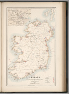
Bevan, G. Phillips
Full Title
Ireland to Illustrate the Marine Commercial Position of the Country by G. Phillips Bevan, F.S.S., F.G.S., 1881.
Publisher
W. &. A.K. Johnston
Author
Stieler, Adolf
Full Title
Deutschland Und Benachbarte Lander. Zur Ubersicht Der Eisenbahnen Und Dampfschiffahrten. Bearbeitet von C. Vogel. Abgeschlossen im August 1871. Gestochen von H. Eberhardt. Gotha: Justus Perthes. 1872.
Publisher
Justus Perthes
Author
Hammond, C.S.
Full Title
Arctic Ocean. 9471. Antarctica. Pacific Ocean. 2426.
Publisher
Garden City Publishing Company, Inc.
Author
[Collins, Greenvile, Moll, Herman, d. 1732]
Full Title
A chart of part of ye sea coast of England, Holland & Flanders &c. Shewing the sands, banks, depth of water, bearing, and the course of the principal tracts from the River Thames, and Harwich, &c. to ye Texel, Helevoet Sluys, Ostend, Calais, and their distances in English miles, with remarks. By Herman Moll Geographer, according to Capt. G. Collins. (Printed and sold by T. Bowles next ye Chapter House in St. Pauls Churchyard, & I. Bowles at ye Black Horse in Cornhill. 1736?)
Publisher
Thos. Bowles and John Bowles
Author
Mitchell, Samuel Augustus Jr.
Full Title
Railroad map of the United States, showing the through lines of communication from the Atlantic to the Pacific, together with the various steamship lines along the seaboard. Copyright by Wm. M. Bradley & Bro. 1884.
Publisher
Wm. M. Bradley & Bro.
Full Title
Railroad map of the United States, showing the through lines of communication from the Atlantic to the Pacific, together with the various steamship lines along the seaboard. W. H. Gamble, Sc. Copyright 1886 by Wm. M. Bradley & Bro.
Publisher
Wm. M. Bradley & Bro.
|