Browse All

1846 Planiglob zur Ubersicht der Verbreitung … World Atlas Planiglob zur Ubersicht der Verbreitung … |

1846 Planiglob zur Ubersicht der Verbreitung … World Atlas Planiglob zur Ubersicht der Verbreitung … |

1847 Ubersicht von Europa; mit ethnograph. World Atlas Ubersicht von Europa; mit ethnograph. Be … |

1847 Ethnographische Karte von Europa. World Atlas Ethnographische Karte von Europa. Auf F. … |

1848 Deutschland, Niederlande, Belgien und Sc … World Atlas Deutschland, Niederlande, Belgien und Sc … |

1846 Ethnographische Karte der Osterreichisch … World Atlas Ethnographische Karte der Osterreichisch … |

1847 Sprachkarte von Frankreich. World Atlas Sprachkarte von Frankreich. 8te Abtheilu … |

1847 Die Britischen Inseln: Volker und Sprach … World Atlas Die Britischen Inseln: Volker und Sprach … |

1848 Das Russische Reich nach seinen ethnogra … World Atlas Das Russische Reich nach seinen ethnogra … |

1847 Volker-Karte der Indischen Welt. World Atlas Volker-Karte der Indischen Welt. Entworf … |

1848 Die Volker des Kaukasus U.S.W. World Atlas Die Volker des Kaukasus U.S.W. gezeichne … |

1846 Ethnographische Karte von Afrika. World Atlas Ethnographische Karte von Afrika von HBg … |

1846 Ethnographische Karte von Nordamerika. World Atlas Ethnographische Karte von Nordamerika. N … |

1847 Ethnographische Karte von Sud-Amerika. World Atlas Ethnographische Karte von Sud-Amerika. H … |
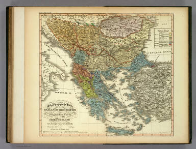
1847 Ethnographische Karte des Osmanischen Re … World Atlas Ethnographische Karte des Osmanischen Re … |

1856 Patagonia ... South Orkney ... Falkland … World Atlas Patagonia (with) South Orkney Or Powell' … |

1856 Europe. World Atlas Europe. Published By J.H. Colton & Co. N … |

1856 England and Wales. World Atlas England And Wales. (with) Scilly Isles. … |

1856 The Environs Of London. World Atlas The Environs Of London. Published By J.H … |

1856 Scotland. World Atlas Scotland. (with) two inset maps: Orkney … |

1856 Ireland. World Atlas Ireland. Published By J.H. Colton & Co. … |

1856 France. World Atlas France (with) Corsica. Published By J.H. … |

1856 The Environs Of Paris. World Atlas The Environs Of Paris. Published By J.H. … |

1856 Spain and Portugal. World Atlas Spain And Portugal. (with) inset map of … |

1823 Eastern Hemisphere. World Atlas Eastern Hemisphere. H.S. Tanner sc. |

1856 Mountains & Rivers. World Atlas Mountains & Rivers. Published by J.H. Co … |

1856 Comparative Size of Lakes and Islands. World Atlas Comparative Size of Lakes and Islands. ( … |

1856 Map of The World Illustrating..Land...Co … World Atlas Map of The World Illustrating the princi … |

1856 Map of The World Illustrating ... Meteor … World Atlas Map of The World Illustrating The Princi … |

1856 Map of The World Showing ... The Animal … World Atlas Map of The World Showing the Geographica … |

1856 Colton's Map Of The World On Mercator's … World Atlas Colton's Map Of The World On Mercator's … |

1856 Western Hemisphere. World Atlas Western Hemisphere. Published by J.H. Co … |

1856 Eastern Hemisphere. World Atlas Eastern Hemisphere. Published by J.H. Co … |

1856 Northern Regions. World Atlas Northern Regions. Published by J.H. Colt … |

1856 Southern Regions. World Atlas Southern Regions. Published by J.H. Colt … |

1856 North America. World Atlas North America. Published by J.H. Colton … |

1856 British, Russian & Danish Possessions In … World Atlas Northern America. British, Russian & Dan … |

1856 New Brunswick, Nova Scotia, Newfoundland … World Atlas New Brunswick, Nova Scotia, Newfoundland … |

1856 Canada East Or Lower Canada And New Brun … World Atlas Canada East Or Lower Canada And New Brun … |

1856 Canada West or Upper Canada. World Atlas Canada West Or Upper Canada. (with) two … |

1856 The United States Of America. World Atlas The United States Of America. Published … |

1856 Maine. World Atlas Maine. Published by J.H. Colton & Co. 17 … |

1856 New Hampshire. World Atlas New Hampshire. Published by J.H. Colton … |

1856 Vermont. World Atlas Vermont. Published by J.H. Colton & Co. … |

1856 Massachusetts And Rhode Island. World Atlas Massachusetts And Rhode Island. (with) V … |

1856 Map Of Boston And Adjacent Cities. World Atlas Map Of Boston And Adjacent Cities. Publi … |

1856 Connecticut. World Atlas Connecticut With Portions Of New York & … |

1856 New York. World Atlas New York. (with) two inset maps: Vicinit … |

1856 Map Of New York And The Adjacent Cities. World Atlas Map Of New York And The Adjacent Cities. … |

1856 New Jersey. World Atlas New Jersey. Published by J.H. Colton & C … |