Browse All

1790 England and Wales (Northern section) World Atlas England and Wales, drawn from the most a … |

1790 England and Wales (Southern section) World Atlas (England and Wales, drawn from the most … |

1790 Composite: England, Wales. World Atlas (Composite of) England and Wales, drawn … |

1790 A new and correct map of Scotland or Nor … World Atlas A new and correct map of Scotland or Nor … |

1790 General Map (London Environs). National Atlas General Map (London Environs). Published … |

1790 General Plan for Trusts of the Turnpike … National Atlas General Plan for Explaining the differen … |

1790 Map Legend, and London to Hampton Court. National Atlas Explanation, Advertisement, London to Ha … |

1790 Brentford to Bagshot, Virginia Water to … National Atlas Brentford to Bagshot, Virginia Water to … |

1790 Egham to Binfield, Hounslow to Windsor. National Atlas Egham to Binfield, Hounslow to Windsor. |

1790 Colnbrook to Maidenhead, London to High … National Atlas Colnbrook to Maidenhead, London to High … |

1790 Uxbridge to Amersham. National Atlas Uxbridge to Amersham. |

1790 London to Tring. National Atlas London to Tring. |

1790 Watford to Rickmans Worth to Amersham, W … National Atlas Watford to Rickmans Worth to Amersham, W … |

1790 London to Highgate & Hampstead to Hendon … National Atlas London to Highgate & Hampstead to Hendon … |

1790 Chipping Barnet to Welwyn, London to Her … National Atlas Chipping Barnet to Welwyn, London to Her … |

1790 Hoddesdon to Ware, Potters Bar to Ware, … National Atlas Hoddesdon to Ware, Potters Bar to Ware, … |

1790 London to Chipping Ongar. National Atlas London to Chipping Ongar. |

1790 Stratford to Chelmsford. National Atlas Stratford to Chelmsford. |

1790 London to Rochester. National Atlas London to Rochester. |

1790 New Cross to Maidstone. National Atlas New Cross to Maidstone. |

1790 Lewisham to Tunbridge Wells. National Atlas Lewisham to Tunbridge Wells. |

1790 London to East Grinsted. National Atlas London to East Grinsted. |

1790 Newington to Ryegate. National Atlas Newington to Ryegate. |

1790 Tooting to Dorking. National Atlas Tooting to Dorking. |

1790 Leatherhead to Guildford, London to Guil … National Atlas Leatherhead to Guildford, London to Guil … |

1790 Hampton Court to Staines. National Atlas Hampton Court to Staines. |

1790 London to Richmond. National Atlas London to Richmond. |

1790 A new and correct map of Scotland or Nor … World Atlas (A new and correct map of Scotland or No … |

1790 Composite: Scotland or North Britain. World Atlas (Composite of) A new and correct map of … |

1790 A map of the Kingdom of Ireland (Norther … World Atlas A map of the Kingdom of Ireland, divided … |

1790 A map of the Kingdom of Ireland (Souther … World Atlas (A map of the Kingdom of Ireland, divide … |

1790 Composite: Ireland. World Atlas (Composite map) A map of the Kingdom of … |

1790 A new map of the Kingdom of France. World Atlas A new map of the Kingdom of France divid … |

1790 A new map of the Kingdoms of Spain and P … World Atlas A new map of the Kingdoms of Spain and P … |

1790 A new map of Italy with the islands of S … World Atlas A new map of Italy with the islands of S … |

1790 Map of the Empire of Germany (Northern s … World Atlas Map of the Empire of Germany, including … |

1790 (Map of the Empire of Germany. Southern … World Atlas (Map of the Empire of Germany, including … |

1790 A new map of the Northern States contain … World Atlas A new map of the Northern States contain … |

1790 The European part of the Russian Empire. … World Atlas The European part of the Russian Empire … |

1787 A general map of the world or terraqueou … World Atlas A general map of the world or terraqueou … |
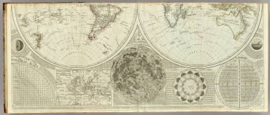
1787 A general map of the world or terraqueou … World Atlas (A general map of the world or terraqueo … |

1787 Composite: World or terraqueous globe. World Atlas (Composite of) A general map of the worl … |

1787 Europe divided into its empires, kingdom … World Atlas Europe divided into its empires, kingdom … |

1787 (Europe divided into its empires, kingdo … World Atlas (Europe divided into its empires, kingdo … |

1787 Composite: Europe. World Atlas (Composite of) Europe divided into its e … |

1786 A new map of the whole continent of Amer … World Atlas A new map of the whole continent of Amer … |

1786 A new map of North America, with the Wes … World Atlas A new map of North America, with the Wes … |

1786 (A new map of North America, with the We … World Atlas (A new map of North America, with the We … |

1786 Composite: North America, West India Isl … World Atlas (Composite of) A new map of North Americ … |

1790 France. World Atlas France, divided into provinces. By W. Fa … |