|
Author
Willard, Emma
Full Title
Introductory Map. To Accompany Willard's History Of The United States. Locations and Wanderings Of The Aboriginal Tribes. (Arrow) Shows The Direction Of their Wanderings. Engraved & Printed by Saml. Maverick.
Publisher
White, Gallaher, & White
Author
Willard, Emma
Full Title
First Map Or Map Of 1578. To Accompany Willard's History Of The United States. (Inset) Queen Elizabeth Signs for Sir Humphrey Gilbert. The First patent Granted by an English Sovereign to Lands Within the Territory of the United States 1578. Engraved & Printed by Saml. Maverick.
Publisher
White, Gallaher, & White
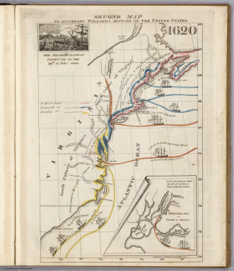
Author
Willard, Emma
Full Title
Second Map. To Accompany Willard's History Of The United States 1620. (Inset) The Pilgrims Land at Plymouth on the 22nd. of Dec. 1620. (inset map) Places Near The Mouth of the Hudson Visited by the Dutch. Engraved & Printed by Saml. Maverick.
Publisher
White, Gallaher, & White
Author
Willard, Emma
Full Title
Third Map or Map Of 1643. To Accompany Willard's History Of The United States. (Inset) The Commencement of the Confederacy in the Union of Plymouth and Massachusetts and New Haven and Connecticut 1643. (inset map) Places Mentioned in the History of the Pequod War. Engraved & Printed by Saml. Maverick N.Y.
Publisher
White, Gallaher, & White
Author
Willard, Emma
Full Title
Fourth Map or Map Of 1692. To Accompany Willard's History Of The United States. (Inset) Massachusetts Receives a New Charter, Including Maine and Other Large Territories by the Arrival of Sir Wm. Phipps. (inset map) Places Mentioned in the History of King Philip's War. (Engraved & Printed by) Saml. Maverick & Co. N.Y.
Publisher
White, Gallaher, & White
Author
Willard, Emma
Full Title
Fifth Map or Map Of 1733. To Accompany Willard's History Of The United States. (Inset) Genl. Oglethorpe with a Colony Commence the Settlement of Georgia 1733. He meets the Indian Chief's in Council at Savannah. (Engraved & Printed by) Saml. Maverick & Co. N.Y.
Publisher
White, Gallaher, & White
Author
Willard, Emma
Full Title
Sixth Map or Map Of 1763. To Accompany Willard's History Of The United States. (Inset) The Death of Gen. Wolf Occurs at the Time of Quebec's Being Taken by the English ... that leads to the Peace of Paris 1763. (inset map) Quebec. Engraved & Printed by Saml. Maverick.
Publisher
White, Gallaher, & White
Author
Willard, Emma
Full Title
Seventh Map or Map Of 1776. To Accompany Willard's History Of The United States. (Inset) A Committee of Five draw up the Declaration of Independence. 1776. (inset map) Boston and Vicinity. (inset) (untitle map showing Lake George and surroundings). (inset) Charleston and Vicinity. Engraved & Printed by Saml. Maverick &Co. N.Y.
Publisher
White, Gallaher, & White
Author
Willard, Emma
Full Title
Eighth Map or Map Of 1789. To Accompany Willard's History Of The United States. (Inset) Federal Government Commen CD 1789. (2 untitled inset maps). (Engraved & Printed by) Saml. Maverick & Co. N.Y.
Publisher
White, Gallaher, & White
Author
Willard, Emma
Full Title
Principal Seat of the Revolutionary War in the Southern Section of the U.S. To Accompany Willard's History Of The United States. (inset map) Principal Seat of the Revolutionary War in the northern section of the U.S. Engraved & Printed by Saml. Maverick.
Publisher
White, Gallaher, & White
Author
Willard, Emma
Full Title
Ninth Map Or Map Of 1826. To Accompany Willard's History Of The United States. Referred to in the History, As the Map of the President Day. 1826. Saml. Maverick & Co. N.Y.
Publisher
White, Gallaher, & White
Author
Willard, Emma
Full Title
Principal Seat of the War of 1812-13-14. To Accompany Willard's History Of The United States. Engraved & Printed by Saml. Maverick. N.Y.
Publisher
White, Gallaher, & White
Full Title
Comparative lengths of the principal rivers throughout the World. Comparative view of mountains. (1829)
Publisher
Collins & Hannay
Full Title
The World. Published by Hilliard, Gray, Little & Wilkins, Boston. H. Morse Sc. (1829)
Publisher
Collins & Hannay
Full Title
North America. Published by Hilliard, Gray, Little & Wilkins, Boston. H. Morse Sc. (1829)
Publisher
Collins & Hannay
Full Title
United States. Published by Hilliard, Gray and Co., Boston. (1829)
Publisher
Collins & Hannay
Full Title
West Indies. Published by Hilliard, Gray, Little & Wilkins, Boston. H. Morse Sc. (1829)
Publisher
Collins & Hannay
Full Title
South America. Published by Hilliard, Gray, Little & Wilkins, Boston. H. Morse Sc. (1829)
Publisher
Collins & Hannay
Full Title
Europe. Boston, Published by Hilliard, Gray, Little and Wilkins. J.V.N. Throop Sc. (1829)
Publisher
Collins & Hannay
Full Title
Asia. Boston, Published by Hilliard, Gray, Little and Wilkins. J.V.N. Throop Sc. (1829)
Publisher
Collins & Hannay
Full Title
Africa. Published by Hilliard, Gray, Little & Wilkins, Boston. H. Morse Sc. (1829)
Publisher
Collins & Hannay
Author
Greenleaf, Moses, 1777-1834
Full Title
Map of the principal rivers, mountains and highland ranges of the State of Maine, by Moses Greenleaf. 1828. Engraved by Wm. Chapin, N. York for Greenleaf's survey of Maine. Published by Shirley & Hyde, Portland, 1829.
Publisher
Shirley & Hyde
Author
[Bouchette, Joseph, Greenleaf, Moses, 1777-1834]
Full Title
Sketch from Bouchette's maps of Upper & Lower Canada and the District of Gaspe. Exhibiting the true range of highlands dividing the waters of the St. Lawrence & the Atlantic, and the imaginary ranges claimed by the British for the boundary of the State of Main. (By Moses Greenleaf). W. Chapin Sc. N. York. Portland, published by Shirley & Hyde, 1829.
Publisher
Shirley & Hyde
Author
Greenleaf, Moses, 1777-1834
Full Title
Sketch of the imaginary ranges of highlands. Reported by the British surveyors under the Treaty of Ghent, as extending across the State of Maine. (By Moses Greenleaf). W. Chapin Sculpt. N. York. (Portland, published by Shirley & Hyde, 1829)
Publisher
Shirley & Hyde
Author
Greenleaf, Moses, 1777-1834
Full Title
Vertical sections, exhibiting the comparative altitudes of the principal highlands and rivers of the State of Maine. By Moses Greenleaf 1828. Engraved by W. Chapin for Greenleaf's Survey of Maine. Published by Shirley & Hyde, Portland, 1829.
Publisher
Shirley & Hyde
Author
Greenleaf, Moses, 1777-1834
Full Title
Map exhibiting the principal original grants & sales of lands in the State of Maine. By Moses Greenleaf. Engraved by Wm. Chapin, N.Y. for Greenleaf's Survey of Maine. Published by Shirley & Hyde, Portland, 1829.
Publisher
Shirley & Hyde
Author
Greenleaf, Moses, 1777-1834
Full Title
Map of the inhabited part of the State of Maine, exhibiting the progress of its settlement since the year 1778, the Representative Districts since the year 1820, and the population and valuation of taxable property in each District at the year 1820. By Moses Greenleaf. Engraved by William Chapin, N.Y. for Greenleaf's Survey of Maine, 1828. Published by Shirley & Hyde, Portland, 1829.
Publisher
Shirley & Hyde
Author
Burr, David H., 1803-1875
Full Title
Map of the counties of New York, Queens, Kings and Richmond. By David H. Burr. Published by the Surveyor General, pursuant to an Act of the Legislature. Entered according to an Act of Congress Jany. 5th. 1829 by David H. Burr of the State of New York. Engd. by Rawdon, Clark & Co., Albany & Rawdon, Wright & Co., New York.
Publisher
D.H. Burr
Author
Burr, David H., 1803-1875
Full Title
Map of the County of Suffolk. By David H. Burr. Published by the Surveyor General, pursuant to an Act of the Legislature. Entered according to an Act of Congress Jany. 5th. 1829 by David H. Burr of the State of New York. Engd. by Rawdon, Clark & Co., Albany & Rawdon, Wright & Co., N. York.
Publisher
D.H. Burr
Author
Burr, David H., 1803-1875
Full Title
Map of the County of Westchester. By David H. Burr. Published by the Surveyor General, pursuant to an Act of the Legislature. Entered according to an Act of Congress Jany. 5th. 1829 by David H. Burr of the State of New York. Engd. by Rawdon, Clark & Co., Albany & Rawdon, Wright & Co., New York.
Publisher
D.H. Burr
Author
Burr, David H., 1803-1875
Full Title
Map of the counties of Dutchess and Putnam. By David H. Burr. Published by the Surveyor General, pursuant to an Act of the Legislature. Entered according to an Act of Congress Jany. 5th. 1829 by David H. Burr of the State of New York. Engd. by Rawdon, Clark & Co., Albany & Rawdon, Wright & Co., New York.
Publisher
D.H. Burr
Author
Burr, David H., 1803-1875
Full Title
Map of the counties of Orange and Rockland. By David H. Burr. Published by the Surveyor General, pursuant to an Act of the Legislature. Entered according to an Act of Congress Jany. 5th. 1829 by David H. Burr of the State of New York. Engd. by Rawdon, Clark & Co., Albany & Rawdon, Wright & Co., N. York.
Publisher
D.H. Burr
Author
Burr, David H., 1803-1875
Full Title
Map of the County of Ulster. By David H. Burr. Published by the Surveyor General, pursuant to an Act of the Legislature. Entered according to an Act of Congress Jany. 5th. 1829 by David H. Burr of the State of New York. Engd. by Rawdon, Clark & Co., Albany & Rawdon, Wright & Co., New York.
Publisher
D.H. Burr
Author
Burr, David H., 1803-1875
Full Title
Map of the County of Sullivan. By David H. Burr. Published by the Surveyor General, pursuant to an Act of the Legislature. Entered according to an Act of Congress Jany. 5th. 1829 by David H. Burr of the State of New York. Engd. by Rawdon, Clark & Co., Albany & Rawdon, Wright & Co., N. York.
Publisher
D.H. Burr
Author
Burr, David H., 1803-1875
Full Title
Map of the County of Delaware. By David H. Burr. Published by the Surveyor General, pursuant to an Act of the Legislature. Entered according to an Act of Congress Jany. 5th. 1829 by David H. Burr of the State of New York. Engd. by Rawdon, Clark & Co., Albany & Rawdon, Wright & Co., N.Y.
Publisher
D.H. Burr
Author
Burr, David H., 1803-1875
Full Title
Map of the County of Greene. By David H. Burr. Published by the Surveyor General, pursuant to an Act of the Legislature. Entered according to an Act of Congress Jany. 5th. 1829 by David H. Burr of the State of New York. Engd. by Rawdon, Clark & Co., Albany & Rawdon, Wright & Co., New York.
Publisher
D.H. Burr
Author
Burr, David H., 1803-1875
Full Title
Map of the County of Columbia. By David H. Burr. Published by the Surveyor General, pursuant to an Act of the Legislature. Entered according to an Act of Congress Jany. 5th. 1829 by David H. Burr of the State of New York. Engd. by Rawdon, Clark & Co., Albany & Rawdon, Wright & Co., New York.
Publisher
D.H. Burr
Author
Burr, David H., 1803-1875
Full Title
Map of the County of Rensselaer. By David H. Burr. Published by the Surveyor General, pursuant to an Act of the Legislature. Entered according to an Act of Congress Jany. 5th. 1829 by David H. Burr of the State of New York. Engd. by Rawdon, Clark & Co., Albany & Rawdon, Wright & Co., New York.
Publisher
D.H. Burr
Author
Burr, David H., 1803-1875
Full Title
Map of the counties of Albany and Schenectady. (with) City of Albany. By David H. Burr. Published by the Surveyor General, pursuant to an Act of the Legislature. Entered according to an Act of Congress Jany. 5th. 1829 by David H. Burr of the State of New York. Engd. by Rawdon, Clark & Co., Albany & Rawdon, Wright & Co., N.Y.
Publisher
D.H. Burr
Author
Burr, David H., 1803-1875
Full Title
Map of the County of Schoharie. By David H. Burr. Published by the Surveyor General, pursuant to an Act of the Legislature. Entered according to an Act of Congress Jany. 5th. 1829 by David H. Burr of the State of New York. Engd. by Rawdon, Clark & Co., Albany & Rawdon, Wright & Co., N.Y.
Publisher
D.H. Burr
Author
Burr, David H., 1803-1875
Full Title
Map of the County of Montgomery. By David H. Burr. Published by the Surveyor General, pursuant to an Act of the Legislature. Entered according to an Act of Congress Jany. 5th. 1829 by David H. Burr of the State of New York. Engd. by Rawdon, Clark & Co., Alby. & Rawdon, Wright & Co., N. York.
Publisher
D.H. Burr
Author
Burr, David H., 1803-1875
Full Title
Map of the County of Hamilton. By David H. Burr. Published by the Surveyor General, pursuant to an Act of the Legislature. Entered according to an Act of Congress Jany. 5th. 1829 by David H. Burr of the State of New York. Engd. by Rawdon, Clark & Co., Albany & Rawdon, Wright & Co., N. York.
Publisher
D.H. Burr
Author
Burr, David H., 1803-1875
Full Title
Map of the County of Saratoga. By David H. Burr. Published by the Surveyor General, pursuant to an Act of the Legislature. Entered according to an Act of Congress Jany. 5th. 1829 by David H. Burr of the State of New York. Engd. by Rawdon, Clark & Co., Albany & Rawdon, Wright & Co., N. York.
Publisher
D.H. Burr
Author
Burr, David H., 1803-1875
Full Title
Map of the County of Washington. By David H. Burr. Published by the Surveyor General, pursuant to an Act of the Legislature. Entered according to an Act of Congress Jany. 5th. 1829 by David H. Burr of the State of New York. Engd. by Rawdon, Clark & Co., Albany & Rawdon, Wright & Co., New York.
Publisher
D.H. Burr
Author
Burr, David H., 1803-1875
Full Title
Map of the County of Warren. By David H. Burr. Published by the Surveyor General, pursuant to an Act of the Legislature. Entered according to an Act of Congress Jany. 5th. 1829 by David H. Burr of the State of N. York. Engd. by Rawdon, Clark & Co., Albany & Rawdon, Wright & Co., N.Y.
Publisher
D.H. Burr
Author
Burr, David H., 1803-1875
Full Title
Map of the County of Essex. By David H. Burr. Published by the Surveyor General, pursuant to an Act of the Legislature. Entered according to an Act of Congress Jany. 5th. 1829 by David H. Burr of the State of New York. Engd. by Rawdon, Clark & Co., Albany & Rawdon, Wright & Co., New York.
Publisher
D.H. Burr
Author
Burr, David H., 1803-1875
Full Title
Map of the County of Clinton. By David H. Burr. Published by the Surveyor General, pursuant to an Act of the Legislature. Entered according to an Act of Congress Jany. 5th. 1829 by David H. Burr of the State of New York. Engd. by Rawdon, Clark & Co., Albany & Rawdon, Wright & Co., N. York.
Publisher
D.H. Burr
Author
Burr, David H., 1803-1875
Full Title
Map of the County of Franklin. By David H. Burr. Published by the Surveyor General, pursuant to an Act of the Legislature. Entered according to an Act of Congress Jany. 5th. 1829 by David H. Burr of the State of New York. Engd. by Rawdon, Clark & Co., Albany & Rawdon, Wright & Co., New York.
Publisher
D.H. Burr
Author
Burr, David H., 1803-1875
Full Title
Map of the County of St. Lawrence. By David H. Burr. Published by the Surveyor General, pursuant to an Act of the Legislature. Entered according to an Act of Congress Jany. 5th. 1829 by David H. Burr of the State of New York. Engd. by Rawdon, Clark & Co., Alby. & Rawdon, Wright & Co., N. York.
Publisher
D.H. Burr
Author
Burr, David H., 1803-1875
Full Title
Map of the County of Jefferson. By David H. Burr. Published by the Surveyor General, pursuant to an Act of the Legislature. Entered according to an Act of Congress Jany. 5th. 1829 by David H. Burr of the State of New York. Engd. by Rawdon, Clark & Co., Albany & Rawdon, Wright & Co., N. York.
Publisher
D.H. Burr
|