Browse All

1864 South America World Atlas South America. J.W. del. (engraved by) S … |

1864 Colombia, British Guyana, Including the … World Atlas Map of Colombia, and British Guyana, Inc … |

1864 Republic of peru and Bolivia World Atlas Republic of peru and Bolivia. J.W. del. … |

1864 Empire of Brazil World Atlas Empire of Brazil. J.W. del. (engraved by … |

1864 Western Australia. World Atlas Western Australia. Published by James Wy … |

1864 Eastern Australia. World Atlas Gold Region of Australia (East Division) … |

1864 World, river systems. School Atlas The World, showing its great river syste … |

1864 World land surface. School Atlas The World showing the diversities of the … |

1864 North America. School Atlas North America. Designed to accompany Cor … |

1864 British Provinces of North America. School Atlas British Provinces of North America. Desi … |

1864 Principal cities U.S. School Atlas Principal cities of the United States. E … |

1864 United States. School Atlas United States. Designed to accompany Cor … |

1864 New England. School Atlas New England or Eastern States. Designed … |

1864 Northern or Middle States. School Atlas Northern or Middle States. Designed to a … |

1864 Southern, Western States. School Atlas Southern and Western States. Designed to … |

1864 Mexico, Central America. School Atlas Mexico, Yucatan, Balize & Central Americ … |

1864 West Indies. School Atlas West Indies. Designed to accompany Corne … |

1864 N.E. United States. School Atlas N. Eastern division of the United States … |

1864 Eastern U.S. School Atlas Eastern division of the United States. D … |

1864 Southern U.S. School Atlas Southern division of the United States. … |

1864 Texas, California. School Atlas Texas. (with) California. Drawn by E. We … |

1864 Western U.S. School Atlas Western division of the United States. D … |

1864 South America. School Atlas South America. Designed to accompany Cor … |

1864 Europe. School Atlas Europe. Designed to accompany Cornell's … |

1864 Continental Europe. School Atlas Western, Central & Southern continental … |

1864 Germanic Confederation. School Atlas Germanic Confederation. Entered ... 1855 … |

1864 British Isles. School Atlas British Isles. Designed to accompany Cor … |

1864 Part of Europe. School Atlas A part of Europe. Designed to accompany … |

1864 Asia. School Atlas Asia. Designed to accompany Cornell's Hi … |

1864 Greece, Turkey, Persia, India. School Atlas Greece, Turkey in Asia and Persia. India … |

1864 Africa. School Atlas Africa. Designed to accompany Cornell's … |

1864 Oceania. School Atlas Oceania. Designed to accompany Cornell's … |
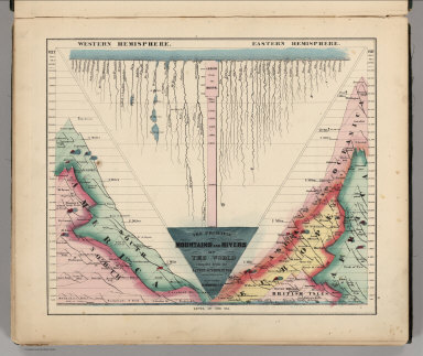
1864 Principal Mountains and Rivers of the Wo … World Atlas The Principal Mountains and Rivers of th … |

1861 New Military Map of the United States World Atlas Johnson's New Military Map of the United … |

1862 Vicinity of Richmond, and Peninsular Cam … World Atlas Johnson's Map of the Vicinity of Richmon … |

1863 Florida World Atlas Johnson's Florida. Published by Johnson … |

1863 South America World Atlas Johnson's South America Published by Joh … |

1863 Italy World Atlas Johnson's Italy, Published by Johnson an … |

1864 46. Woburn, NW Quad. Geologic Atlas 46. Woburn, NW Quad. |

1864 81. Buxton, SW Quad. Geologic Atlas 81. Buxton, SW Quad. |

1859 The World on the Globular Projection . World Atlas A New Map of the World on the Globular P … |

1859 North America. World Atlas Map of North America. 2. Philadelphia, P … |

1859 Canada East (Lower). World Atlas Canada East, formerly Lower Canada. 3. P … |

1859 Canada West (Upper). World Atlas Canada West, formerly Upper Canada. Phil … |

1860 United States. World Atlas A New Map of the United States of Americ … |

1860 Maine. World Atlas A New Map of Maine. Philadelphia, Publis … |

1860 New Hampshire & Vermont. World Atlas Map of New Hampshire & Vermont. Philadel … |

1859 Massachusetts and Rhode Island. World Atlas Map of Massachusetts and Rhode Island. P … |

1859 Connecticut. World Atlas Map of Connecticut. Philadelphia, Publis … |

1859 New York. World Atlas Map of New York Compiled from Latest Aut … |