Who What Where WhenWHEREShow More |
Author
Gray, Ormando Willis
Full Title
Central America. West Indies. (inset) Isthmus of Panama. (inset) City & Harbor of Havana.
Publisher
Stedman, Brown & Lyon
Author
Gray, Ormando Willis
Full Title
Gray's Atlas Map of Mexico. (inset) Territory and Isthmus of Tehuantepec.
Publisher
Stedman, Brown & Lyon
Author
Gray, Ormando Willis
Full Title
Grays Atlas Map of Washington.
Publisher
Stedman, Brown & Lyon
Author
Gray, Ormando Willis
Full Title
Gray's Atlas Map of Maine. New Hampshire.
Publisher
Stedman, Brown & Lyon
Author
Gray, Ormando Willis
Full Title
Gray's Atlas Map of Vermont.
Publisher
Stedman, Brown & Lyon
Author
Gray, Ormando Willis
Full Title
Gray's Atlas Map of Massachusetts and Rhode Island. (inset) Vicinity of Boston.
Publisher
Stedman, Brown & Lyon
Author
Gray, Ormando Willis
Full Title
Map of the Compact Portions of Boston and Adjacent Cities.
Publisher
Stedman, Brown & Lyon
Author
Gray, Ormando Willis
Full Title
Gray's Atlas Map of Connecticut with Portions of New York and Rhode Island.
Publisher
Stedman, Brown & Lyon
Author
Gray, Ormando Willis
Full Title
Gray's Atlas Map of New York. (insets for:) Oswego, Buffalo, Rochester, Syracuse, Albany, Troy, and Vicinity of New York.
Publisher
Stedman, Brown & Lyon
Author
Gray, Ormando Willis
Full Title
Gray's Atlas Map of New York City. Gray's Atlas Map of New Jersey.
Publisher
Stedman, Brown & Lyon
Author
Gray, Ormando Willis
Full Title
Gray's Atlas Map of Delaware and Maryland. (inset) District of Columbia (Washington D.C.).Gray's Atlas City of Baltimore.
Publisher
Stedman, Brown & Lyon
Author
Gray, Ormando Willis
Full Title
Pennsylvania.
Publisher
Stedman, Brown & Lyon
Author
Gray, Ormando Willis
Full Title
Philadelphia. Gray's Atlas Map of Virginia & West Virginia. (insets:) Richmond ... Manchester ... Spring Hill; Norfolk, Portsmouth, and Gosport.
Publisher
Stedman, Brown & Lyon
Author
Gray, Ormando Willis
Full Title
Gray's Atlas Map of North Carolina. (inset) Beaufort Harbor. Gray's Atlas Map of South Carolina. (inset) Plan of Charleston, Vicinity & Harbor (includes plan of Fort Sumter).
Publisher
Stedman, Brown & Lyon
Author
Gray, Ormando Willis
Full Title
Gray's Atlas Map of Georgia.
Publisher
Stedman, Brown & Lyon
Author
Gray, Ormando Willis
Full Title
Gray's Atlas Map of Florida. (inset Plan of the Florida Keys is an extension of main map).
Publisher
Stedman, Brown & Lyon
Author
Gray, Ormando Willis
Full Title
Gray's Atlas Map of Alabama. Gray's Atlas Map of Mississippi.
Publisher
Stedman, Brown & Lyon
Author
Gray, Ormando Willis
Full Title
Gray's Atlas Map of Louisiana. Gray's Atlas Map of Arkansas.
Publisher
Stedman, Brown & Lyon
Author
Gray, Ormando Willis
Full Title
Gray's Atlas Map of Texas. (inset) Plan of Galeston Bay. (inset) Plan of Sabine Lake. Gray;s Atlas Map of Kentucky and Tennessee.
Publisher
Stedman, Brown & Lyon
Author
Gray, Ormando Willis
Full Title
Gray's Atlas Map of Ohio.
Publisher
Stedman, Brown & Lyon
Author
Gray, Ormando Willis
Full Title
Gray's Atlas Map of Indiana.
Publisher
Stedman, Brown & Lyon
Author
Gray, Ormando Willis
Full Title
Gray's Map of Illinois. (inset) Plan of Cook County & Vicinity of Chicago.
Publisher
Stedman, Brown & Lyon
Author
Gray, Ormando Willis
Full Title
Gray's Atlas Map of Missouri.
Publisher
Stedman, Brown & Lyon
Author
Gray, Ormando Willis
Full Title
Gray's Atlas Map of Chicago.
Publisher
Stedman, Brown & Lyon
Author
Gray, Ormando Willis
Full Title
Gray's Atlas Map of Iowa.
Publisher
Stedman, Brown & Lyon
Author
Gray, Ormando Willis
Full Title
Gray's Atlas Map of Lake Superior and the Northern Part of Michigan. No. 1.
Publisher
Stedman, Brown & Lyon
Author
Gray, Ormando Willis
Full Title
Gray's Atlas Map of Michigan. No. 2.
Publisher
Stedman, Brown & Lyon
Author
Gray, Ormando Willis
Full Title
Gray's Atlas Map of Minnesota. (inset continuation of main map).
Publisher
Stedman, Brown & Lyon
Author
Gray, Ormando Willis
Full Title
Gray's Atlas Map of Wisconsin. (inset) Vicinity of Milwaukee. Dakota.
Publisher
Stedman, Brown & Lyon
Author
Gray, Ormando Willis
Full Title
Gray's Atlas Map of Kansas.
Publisher
Stedman, Brown & Lyon
Author
Gray, Ormando Willis
Full Title
Gray's Atlas Map of Indian Territory (Oklahoma). Gray's Atlas Nebraska. Drawn by Frank A. Gray. Entered ...1874 by O.W. Gray ....
Publisher
Stedman, Brown & Lyon
Author
Gray, Ormando Willis
Full Title
Colorado. Idaho, Montana, and Wyoming. Drawn by Frank A. Gray.
Publisher
Stedman, Brown & Lyon
Author
Gray, Ormando Willis
Full Title
Oregon and Washington. Drawn by F.A. Gray.
Publisher
Stedman, Brown & Lyon
Author
Gray, Ormando Willis
Full Title
Gray's Atlas Map of New Mexico and Arizona.
Publisher
Stedman, Brown & Lyon
Author
Gray, Ormando Willis
Full Title
Gray's Atlas California and Nevada. (inset) The Vicinity of San Francisco. (inset) Map of the Yosemite Valley, Mariposa Co., Cal. from the California Geological Survey.
Publisher
Stedman, Brown & Lyon
Author
Gray, Ormando Willis
Full Title
Map of the City of Sacramento, the Capital of California. By J.R. Ray, City Surveyor, 1873.
Publisher
Stedman, Brown & Lyon
Author
Gray, Ormando Willis
Full Title
San Francisco.
Publisher
Stedman, Brown & Lyon
Author
Gray, Ormando Willis
Full Title
Gray's Atlas New Railroad and County Map of the States of Oregon, California, and Nevada Compiled and Drawn by Frank A. Gray. Published by O.W. Gray, Philadelphia. (inset) Enlarged Plan of the Vicinity of San Francisco and Sacramento.
Publisher
Stedman, Brown & Lyon
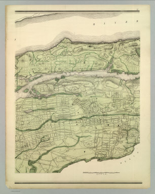
Author
Viele, Egbert L.
Full Title
Topographical Atlas Of The City Of New York Including The Annexed Territory. I. (Southernmost portion). Showing original water courses and made land. Prepared Under The Direction Of Egbert L. Viele, Civil and Topographical Engineer. 234 Broadway, N.Y. 1874. Eugene Quackenbush, C.E. Entered ... 1874, by Egbert L. Viele in the Office of the Librarian of Congress. Julius Bien, Photo Lith.
Publisher
E.L. Viele
Author
Viele, Egbert L.
Full Title
Topographical Atlas Of The City Of New York Including The Annexed Territory. II. (Next to southernmost portion). Showing original water courses and made land. Prepared Under The Direction Of Egbert L. Viele, Civil and Topographical Engineer. 234 Broadway, N.Y. 1874. Eugene Quackenbush, C.E. Entered ... 1874, by Egbert L. Viele in the Office of the Librarian of Congress. Julius Bien, Photo Lith.
Publisher
E.L. Viele
Author
Viele, Egbert L.
Full Title
Topographical Atlas Of The City Of New York Including The Annexed Territory. III. (Central portion). Showing original water courses and made land. Prepared Under The Direction Of Egbert L. Viele, Civil and Topographical Engineer. 234 Broadway, N.Y. 1874. Eugene Quackenbush, C.E. Entered ... 1874, by Egbert L. Viele in the Office of the Librarian of Congress. Julius Bien, Photo Lith.
Publisher
E.L. Viele
Author
Viele, Egbert L.
Full Title
Topographical Atlas Of The City Of New York Including The Annexed Territory. IV. (Next to northernmost portion). Showing original water courses and made land. Prepared Under The Direction Of Egbert L. Viele, Civil and Topographical Engineer. 234 Broadway, N.Y. 1874. Eugene Quackenbush, C.E. Entered ... 1874, by Egbert L. Viele in the Office of the Librarian of Congress. Julius Bien, Photo Lith.
Publisher
E.L. Viele
Author
Viele, Egbert L.
Full Title
Topographical Atlas Of The City Of New York Including The Annexed Territory. V. (Northernmost portion). Showing original water courses and made land. Prepared Under The Direction Of Egbert L. Viele, Civil and Topographical Engineer. 234 Broadway, N.Y. 1874. Eugene Quackenbush, C.E. Entered ... 1874, by Egbert L. Viele in the Office of the Librarian of Congress. Julius Bien, Photo Lith.
Publisher
E.L. Viele
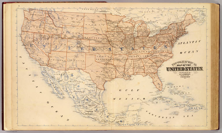
Author
Andreas, A. T. (Alfred Theodore), 1839-1900
Full Title
Topographical map of the United States. Published by A.T. Andreas, Lakeside Building, Chicago, 1873. (Chas. Shober & Co. Proprietors of Chicago Lith. Co.)
Publisher
A.T. Andreas
Author
[Vorzet, Ed.Dumas, Le Comte de Paris]
Full Title
Planche I. Carte Generale du Theatre de la Guerre. (inset) Cote de la Georgie. Dessine par Ed. Dumas Vorzet. Michel Levy, freres. Editeurs. Imp. Becquet, Paris. Grave par L. Wuhrer, R. Gay-Lussac 52.
Publisher
Michel Levy Freres
Author
[Vorzet, Ed.Dumas, Le Comte de Paris]
Full Title
Planche II. Virginie et Maryland. (inset) Environs de Leesburg. Carnifex Ferry. Dessine par Ed. Dumas Vorzet. Michel Levy, freres. Editeurs. Imp. Becquet, Paris. Grave par L. Wuhrer, R. Gay-Lussac 52.
Publisher
Michel Levy Freres
Author
[Vorzet, Ed.Dumas, Le Comte de Paris]
Full Title
Planche III. Kentucky et Tennessee. Dessine par Ed. Dumas Vorzet. Michel Levy, freres. Editeurs. Imp. Becquet, Paris. Grave par L. Wuhrer, R. Gay-Lussac 52.
Publisher
Michel Levy Freres
Author
[Vorzet, Ed.Dumas, Le Comte de Paris]
Full Title
Planche IV. Missouri et Arkansas. (insets) Environs de Lexington. Champ de Bataille de Wilson's Creek. Dessine par Ed. Dumas Vorzet. Michel Levy, freres. Editeurs. Imp. Becquet, Paris. Grave par L. Wuhrer, R. Gay-Lussac 52.
Publisher
Michel Levy Freres
Author
[Vorzet, Ed.Dumas, Le Comte de Paris]
Full Title
Planche V. Environs de Washington et du Bull Run. Dessine par Ed. Dumas Vorzet. Michel Levy, freres. Editeurs. Imp. Becquet, Paris. Grave par L. Wuhrer, R. Gay-Lussac 52.
Publisher
Michel Levy Freres
Author
[Vorzet, Ed.Dumas, Le Comte de Paris]
Full Title
Planche VI. Pamlico Sound. (Carolina du Nord). Dessine par Ed. Dumas Vorzet. Michel Levy, freres. Editeurs. Imp. Becquet, Paris. Grave par L. Wuhrer, R. Gay-Lussac 52.
Publisher
Michel Levy Freres
|