Browse All

1875 Plans of Ottumwa, Russell, Scranton, Tyr … State Atlas Plan of Ottumwa, Wapello Co. (with) Plan … |

1875 Map of Monroe County, State of Iowa. State Atlas Map of Monroe County, State of Iowa. Cha … |

1875 Map of Lucas County, State of Iowa. State Atlas Map of Lucas County, State of Iowa. Chas … |

1875 Map of Clarke County, State of Iowa. State Atlas Map of Clarke County, State of Iowa. Cha … |

1875 Plans of Glenwood, Denison, Hastings, Vi … State Atlas Plan of Glenwood ... Mills Co. (with) Pl … |

1875 Map of Union County, State of Iowa. State Atlas Map of Union County, State of Iowa. Chas … |

1875 Map of Adams County, State of Iowa. State Atlas Map of Adams County, State of Iowa. Chas … |

1875 Map of Montgomery County, State of Iowa. State Atlas Map of Montgomery County, State of Iowa. … |

1875 Plans of Red Oak Junction, Prescott, Wal … State Atlas Plan of Red Oak Junction ... Montgomery … |

1875 Plans of Shenandoah, Bedford, Avery, Aft … State Atlas Plan of Shenandoah ... Page Co. (with) P … |

1875 Map of Taylor County, State of Iowa. State Atlas Map of Taylor County, State of Iowa. Cha … |

1875 Map of Ringgold County, State of Iowa. State Atlas Map of Ringgold County, State of Iowa. C … |

1875 Map of Decatur County, State of Iowa. State Atlas Map of Decatur County, State of Iowa. Ch … |

1875 Plans of Centerville, Leon, Moulton, Sey … State Atlas Plan of Centerville, Appanoose Co. (with … |

1875 Map of Wayne County, State of Iowa. State Atlas Map of Wayne County, State of Iowa. Chas … |

1875 Map of Appanoose County, State of Iowa. State Atlas Map of Appanoose County, State of Iowa. … |

1875 Map of Davis County, State of Iowa. State Atlas Map of Davis County, State of Iowa. Chas … |

1875 Fairfield, Carroll, Birmingham, Dunlap, … State Atlas Plan of Fairfield, Jefferson Co. (with) … |

1875 Plans of Fort Madison, Bloomfield and Me … State Atlas Plan of Fort Madison, Lee County, Iowa. … |

1875 Map of Van Buren County, State of Iowa. State Atlas Map of Van Buren County, State of Iowa. … |

1875 Map of Des Moines County, State of Iowa. State Atlas Map of Des Moines County, State of Iowa. … |

1875 Plans of Burlington, Greenfield, Fontane … State Atlas Plan of Burlington, Des Moines Co. (with … |

1875 Map of Lee County and Montrose, State of … State Atlas Map of Lee County, State of Iowa. (with) … |

1875 Plans of Keokuk, Forest City, Greene and … State Atlas Plan of Keokuk, Lee Co. (with) Plan of p … |

1875 Geological map of the State of Iowa, Cli … State Atlas Geological map of the State of Iowa ... … |

1875 Western Hemisphere. State Atlas Western Hemisphere. (Published by the An … |

1875 Eastern Hemisphere. State Atlas Eastern Hemisphere. Chas. Shober & Co., … |

1875 Maps of the State of Iowa showing repres … State Atlas Map of the State of Iowa showing represe … |

1875 Maps of the State of Iowa showing congre … State Atlas Map of the State of Iowa showing congres … |

1875 New railroad map of the United States, . … State Atlas New railroad map of the United States, t … |

1875 Sectional map of Iowa. State Atlas Sectional map of Iowa, showing civil & c … |

1875 Population - United States census, 1870. … State Atlas Population - United States census, 1870. … |

1875 Agricultural productions colored by grad … State Atlas Agricultural productions colored by grad … |

1875 Vital statistics, United Census, 1870: D … State Atlas Vital statistics, United Census, 1870: D … |

1875 Map of Allamakee County, State of Iowa. State Atlas Map of Allamakee County, State of Iowa. … |

1875 Plans of Cresco, Butler Centre, Waukon, … State Atlas Plan of Cresco, Howard Co. (with) Plan o … |

1875 Map of Winneshiek County, State of Iowa. State Atlas Map of Winneshiek County, State of Iowa. … |

1875 Plans of Decorah, Charles City, Northwoo … State Atlas Plan of the City of Decorah, Winneshiek … |

1875 Map of Howard County, State of Iowa. State Atlas Map of Howard County, State of Iowa. Cha … |

1875 Map of Mitchell County, State of Iowa. State Atlas Map of Mitchell County, State of Iowa. ( … |

1875 Map of Worth County, State of Iowa. State Atlas Map of Worth County, State of Iowa. (Pub … |

1875 Map of Grundy County, State of Iowa, and … State Atlas Map of Grundy County, State of Iowa. (wi … |

1875 Map of Hardin County, State of Iowa. State Atlas Map of Hardin County, State of Iowa. Cha … |

1875 Map of Mills County, State of Iowa. State Atlas Map of Mills County, State of Iowa. Chas … |

1875 Plans of Hamburg, Sidney, Farragut, Rive … State Atlas Plan of Hamburg ... Fremont Co. (with) P … |

1875 Map of Fremont County, State of Iowa. State Atlas Map of Fremont County, State of Iowa. Ch … |

1875 Map of Page County, State of Iowa. State Atlas Map of Page County, State of Iowa. Chas. … |

1875 Counties of St. John & Kings, New Brunsw … County Atlas Plan of the Counties of St. John & Kings … |
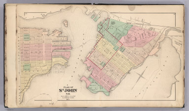
1875 St. John, N.B. (New Brunswick). County Atlas Plan of St. John, N.B. by Roe & Colby. ! … |

1875 St. John: Dukes & Sydney Wards. (New Bru … County Atlas Plan of St. John, Dukes & Sydney Wards. … |