Who What Where WhenWHAT
WHERE
|
Author
Hayes, Eli L.
Full Title
Martin's Ferry, Belmont Co., Ohio. (... compiled & drawn for the publishers by E.L. Hayes, assisted by E.F. Hayes, C.M. Beresford, assisted by S.A. Charpiot, F.L. Sanford, J.H. Sherman. Published by Titus, Simmons & Titus ... Phila. 1877. Eng. by Worley & Bracher ... Printed by H.J. Toudy & Co. ... Oldach & Mergenthaler Binders ...)
Publisher
Titus, Simmons & Titus
Author
Hayes, Eli L.
Full Title
North Wheeling, first, second, third & fourth wards, Ohio Co., W. Va. (... compiled & drawn for the publishers by E.L. Hayes, assisted by E.F. Hayes, C.M. Beresford, assisted by S.A. Charpiot, F.L. Sanford, J.H. Sherman. Published by Titus, Simmons & Titus ... Phila. 1877. Eng. by Worley & Bracher ... Printed by H.J. Toudy & Co. ... Oldach & Mergenthaler Binders ...)
Publisher
Titus, Simmons & Titus
Author
Hayes, Eli L.
Full Title
South Wheeling, fifth, sixth & eighth wards, Ohio Co., Wt. Va. (... compiled & drawn for the publishers by E.L. Hayes, assisted by E.F. Hayes, C.M. Beresford, assisted by S.A. Charpiot, F.L. Sanford, J.H. Sherman. Published by Titus, Simmons & Titus ... Phila. 1877. Eng. by Worley & Bracher ... Printed by H.J. Toudy & Co. ... Oldach & Mergenthaler Binders ...)
Publisher
Titus, Simmons & Titus
Author
Hayes, Eli L.
Full Title
Wheeling Island, seventh ward, Ohio Co., Wt. Va. (... compiled & drawn for the publishers by E.L. Hayes, assisted by E.F. Hayes, C.M. Beresford, assisted by S.A. Charpiot, F.L. Sanford, J.H. Sherman. Published by Titus, Simmons & Titus ... Phila. 1877. Eng. by Worley & Bracher ... Printed by H.J. Toudy & Co. ... Oldach & Mergenthaler Binders ...)
Publisher
Titus, Simmons & Titus
Author
Hayes, Eli L.
Full Title
City of Bellaire, Belmont Co., Ohio. (... compiled & drawn for the publishers by E.L. Hayes, assisted by E.F. Hayes, C.M. Beresford, assisted by S.A. Charpiot, F.L. Sanford, J.H. Sherman. Published by Titus, Simmons & Titus ... Phila. 1877. Eng. by Worley & Bracher ... Printed by H.J. Toudy & Co. ... Oldach & Mergenthaler Binders ...)
Publisher
Titus, Simmons & Titus
Author
Hayes, Eli L.
Full Title
Bridgeport, Belmont Co., O. (with) Industry and Powhattan, Belmont Co., Ohio. (... compiled & drawn for the publishers by E.L. Hayes, assisted by E.F. Hayes, C.M. Beresford, assisted by S.A. Charpiot, F.L. Sanford, J.H. Sherman. Published by Titus, Simmons & Titus ... Phila. 1877. Eng. by Worley & Bracher ... Printed by H.J. Toudy & Co. ... Oldach & Mergenthaler Binders ...)
Publisher
Titus, Simmons & Titus
Author
Hayes, Eli L.
Full Title
Moundsville, Marshall Co., W. Va. (with) Belpre, Washington Co., O. (... compiled & drawn for the publishers by E.L. Hayes, assisted by E.F. Hayes, C.M. Beresford, assisted by S.A. Charpiot, F.L. Sanford, J.H. Sherman. Published by Titus, Simmons & Titus ... Phila. 1877. Eng. by Worley & Bracher ... Printed by H.J. Toudy & Co. ... Oldach & Mergenthaler Binders ...)
Publisher
Titus, Simmons & Titus
Author
Hayes, Eli L.
Full Title
Upper Ohio River and Valley part VII, 96 to 116 miles below Pittsburgh, 351 to 371 miles above Cincinnati. (with) Steinersville, Belmont Co., O. (with) Sunfish, Clarington, Monroe Co., O. (... compiled & drawn for the publishers by E.L. Hayes, assisted by E.F. Hayes, C.M. Beresford, assisted by S.A. Charpiot, F.L. Sanford, J.H. Sherman. Published by Titus, Simmons & Titus ... Phila. 1877. Eng. by Worley & Bracher ... Printed by H.J. Toudy & Co. ... Oldach & Mergenthaler Binders ...)
Publisher
Titus, Simmons & Titus
Author
Hayes, Eli L.
Full Title
Upper Ohio River and Valley part VIII, 117 to 135 miles below Pittsburgh, 332 to 350 miles above Cincinnati. (with) Baresville, Monroe County, O., Hannibal P.O. (with) Sardis, Monroe Co., O. (with) New Martinsville, Wetzel Co., W. Va. (... compiled & drawn for the publishers by E.L. Hayes, assisted by E.F. Hayes, C.M. Beresford, assisted by S.A. Charpiot, F.L. Sanford, J.H. Sherman. Published by Titus, Simmons & Titus ... Phila. 1877. Eng. by Worley & Bracher ... Printed by H.J. Toudy & Co. ... Oldach & Mergenthaler Binders ...)
Publisher
Titus, Simmons & Titus
Author
Hayes, Eli L.
Full Title
Upper Ohio River and Valley part IX, 136 to 151 miles below Pittsburgh, 3l6 to 331 miles above Cincinnati. (with) Sistersville, Tyler County, West Virginia. (with) Cochransville, Centerview P.O., Monroe Co., O. (with) Grandview, Washington Co., O. (with) Matamoras, Washington Co., Ohio, New Matamoras P.O. (... compiled & drawn for the publishers by E.L. Hayes, assisted by E.F. Hayes, C.M. Beresford, assisted by S.A. Charpiot, F.L. Sanford, J.H. Sherman. Published by Titus, Simmons & Titus ... Phila. 1877. Eng. by Worley & Bracher ... Printed by H.J. Toudy & Co. ... Oldach & Mergenthaler Binders ...)
Publisher
Titus, Simmons & Titus
Author
Hayes, Eli L.
Full Title
Upper Ohio River and Valley part X, 152 to 172 miles below Pittsburgh, 295 to 315 miles above Cincinnati. (with) St. Mary's, Pleasants Co., W. Va. (with) Newport, Washington Co., O. (with) Williamstown, Wood Co., W. Va. (... compiled & drawn for the publishers by E.L. Hayes, assisted by E.F. Hayes, C.M. Beresford, assisted by S.A. Charpiot, F.L. Sanford, J.H. Sherman. Published by Titus, Simmons & Titus ... Phila. 1877. Eng. by Worley & Bracher ... Printed by H.J. Toudy & Co. ... Oldach & Mergenthaler Binders ...)
Publisher
Titus, Simmons & Titus
Author
Hayes, Eli L.
Full Title
Vanceburg, Lewis Co., Ky. (with) Concord, Lewis Co., Ky. (... compiled & drawn for the publishers by E.L. Hayes, assisted by E.F. Hayes, C.M. Beresford, assisted by S.A. Charpiot, F.L. Sanford, J.H. Sherman. Published by Titus, Simmons & Titus ... Phila. 1877. Eng. by Worley & Bracher ... Printed by H.J. Toudy & Co. ... Oldach & Mergenthaler Binders ...)
Publisher
Titus, Simmons & Titus
Author
Hayes, Eli L.
Full Title
Upper Ohio River and Valley part XXII, 382 to 400 miles below Pittsburgh, 67 to 85 miles above Cincinnati. (with) Manchester, Adams Co., O. (with) Wrightsville, Adams Co., O. (... compiled & drawn for the publishers by E.L. Hayes, assisted by E.F. Hayes, C.M. Beresford, assisted by S.A. Charpiot, F.L. Sanford, J.H. Sherman. Published by Titus, Simmons & Titus ... Phila. 1877. Eng. by Worley & Bracher ... Printed by H.J. Toudy & Co. ... Oldach & Mergenthaler Binders ...)
Publisher
Titus, Simmons & Titus
Author
Hayes, Eli L.
Full Title
Upper Ohio River and Valley part XXIII, 401 to 418 miles below Pittsburgh, 49 to 66 miles above Cincinnati. (with) Aberdeen ... (with) Levanna ... (both) Brown Co., O. (... compiled & drawn for the publishers by E.L. Hayes, assisted by E.F. Hayes, C.M. Beresford, assisted by S.A. Charpiot, F.L. Sanford, J.H. Sherman. Published by Titus, Simmons & Titus ... Phila. 1877. Eng. by Worley & Bracher ... Printed by H.J. Toudy & Co. ... Oldach & Mergenthaler Binders ...)
Publisher
Titus, Simmons & Titus
Author
Hayes, Eli L.
Full Title
Ripley, Brown Co., Ohio. (... compiled & drawn for the publishers by E.L. Hayes, assisted by E.F. Hayes, C.M. Beresford, assisted by S.A. Charpiot, F.L. Sanford, J.H. Sherman. Published by Titus, Simmons & Titus ... Phila. 1877. Eng. by Worley & Bracher ... Printed by H.J. Toudy & Co. ... Oldach & Mergenthaler Binders ...)
Publisher
Titus, Simmons & Titus
Author
Hayes, Eli L.
Full Title
City of Maysville ... (with) Chester & Woodville ... (with) Dover ... (all) Mason Co., Ky. (... compiled & drawn for the publishers by E.L. Hayes, assisted by E.F. Hayes, C.M. Beresford, assisted by S.A. Charpiot, F.L. Sanford, J.H. Sherman. Published by Titus, Simmons & Titus ... Phila. 1877. Eng. by Worley & Bracher ... Printed by H.J. Toudy & Co. ... Oldach & Mergenthaler Binders ...)
Publisher
Titus, Simmons & Titus
Author
Hayes, Eli L.
Full Title
City of Augusta ... (with) Tietzville (Rock Springs) ... (with) Foster ... (with) Wellsburgh ... (all) Bracken Co., Ky. (... compiled & drawn for the publishers by E.L. Hayes, assisted by E.F. Hayes, C.M. Beresford, assisted by S.A. Charpiot, F.L. Sanford, J.H. Sherman. Published by Titus, Simmons & Titus ... Phila. 1877. Eng. by Worley & Bracher ... Printed by H.J. Toudy & Co. ... Oldach & Mergenthaler Binders ...)
Publisher
Titus, Simmons & Titus
Author
Hayes, Eli L.
Full Title
Upper Ohio River and Valley part XXIV, 418 to 434 miles below Pittsburgh, 33 to 49 miles above Cincinnati. (with) Chilo ... (with) Rural ... (with) Utopia ... (all) Clermont Co., O. (... compiled & drawn for the publishers by E.L. Hayes, assisted by E.F. Hayes, C.M. Beresford, assisted by S.A. Charpiot, F.L. Sanford, J.H. Sherman. Published by Titus, Simmons & Titus ... Phila. 1877. Eng. by Worley & Bracher ... Printed by H.J. Toudy & Co. ... Oldach & Mergenthaler Binders ...)
Publisher
Titus, Simmons & Titus
Author
Hayes, Eli L.
Full Title
Higginsport, Brown Co., Ohio. (with) Neville ... (with) Point Pleasant ... (both) Clermont Co., Ohio. (... compiled & drawn for the publishers by E.L. Hayes, assisted by E.F. Hayes, C.M. Beresford, assisted by S.A. Charpiot, F.L. Sanford, J.H. Sherman. Published by Titus, Simmons & Titus ... Phila. 1877. Eng. by Worley & Bracher ... Printed by H.J. Toudy & Co. ... Oldach & Mergenthaler Binders ...)
Publisher
Titus, Simmons & Titus
Author
Hayes, Eli L.
Full Title
New Richmond, Clermont co., Ohio. (with) Moscow, Clermont Co., O. (... compiled & drawn for the publishers by E.L. Hayes, assisted by E.F. Hayes, C.M. Beresford, assisted by S.A. Charpiot, F.L. Sanford, J.H. Sherman. Published by Titus, Simmons & Titus ... Phila. 1877. Eng. by Worley & Bracher ... Printed by H.J. Toudy & Co. ... Oldach & Mergenthaler Binders ...)
Publisher
Titus, Simmons & Titus
Author
Hayes, Eli L.
Full Title
Upper Ohio River and Valley part XXVI, 452 to 467 miles below Pittsburgh, from Cincinnati to 15 miles above. (... compiled & drawn for the publishers by E.L. Hayes, assisted by E.F. Hayes, C.M. Beresford, assisted by S.A. Charpiot, F.L. Sanford, J.H. Sherman. Published by Titus, Simmons & Titus ... Phila. 1877. Eng. by Worley & Bracher ... Printed by H.J. Toudy & Co. ... Oldach & Mergenthaler Binders ...)
Publisher
Titus, Simmons & Titus
Author
Hayes, Eli L.
Full Title
Cincinnati, Ohio and vicinity. (... compiled & drawn for the publishers by E.L. Hayes, assisted by E.F. Hayes, C.M. Beresford, assisted by S.A. Charpiot, F.L. Sanford, J.H. Sherman. Published by Titus, Simmons & Titus ... Phila. 1877. Eng. by Worley & Bracher ... Printed by H.J. Toudy & Co. ... Oldach & Mergenthaler Binders ...)
Publisher
Titus, Simmons & Titus
Author
Hayes, Eli L.
Full Title
Index map to Atlas of the Upper Ohio River & Valley. (... compiled & drawn for the publishers by E.L. Hayes, assisted by E.F. Hayes, C.M. Beresford, assisted by S.A. Charpiot, F.L. Sanford, J.H. Sherman. Published by Titus, Simmons & Titus ... Phila. 1877. Eng. by Worley & Bracher ... Printed by H.J. Toudy & Co. ... Oldach & Mergenthaler Binders ...)
Publisher
Titus, Simmons & Titus
Author
Hayes, Eli L.
Full Title
Pittsburgh and Allegheny, Penna. (... compiled & drawn for the publishers by E.L. Hayes, assisted by E.F. Hayes, C.M. Beresford, assisted by S.A. Charpiot, F.L. Sanford, J.H. Sherman. Published by Titus, Simmons & Titus ... Phila. 1877. Eng. by Worley & Bracher ... Printed by H.J. Toudy & Co. ... Oldach & Mergenthaler Binders ...)
Publisher
Titus, Simmons & Titus
Author
Hayes, Eli L.
Full Title
Upper Ohio River and Valley part I from Pittsburgh to 11 miles below 456 to 467 miles above Cincinnati. (with) Middletown, Vancefort P.O. ... (with) Riverside, Allegheny Co. ... (both) Allegheny Co., Pa. (... compiled & drawn for the publishers by E.L. Hayes, assisted by E.F. Hayes, C.M. Beresford, assisted by S.A. Charpiot, F.L. Sanford, J.H. Sherman. Published by Titus, Simmons & Titus ... Phila. 1877. Eng. by Worley & Bracher ... Printed by H.J. Toudy & Co. ... Oldach & Mergenthaler Binders ...)
Publisher
Titus, Simmons & Titus
Author
Hayes, Eli L.
Full Title
Bellevue Borough, Robella P.O. ... (with) McKee's Rocks ... (both) Allegheny Co., Penna. (... compiled & drawn for the publishers by E.L. Hayes, assisted by E.F. Hayes, C.M. Beresford, assisted by S.A. Charpiot, F.L. Sanford, J.H. Sherman. Published by Titus, Simmons & Titus ... Phila. 1877. Eng. by Worley & Bracher ... Printed by H.J. Toudy & Co. ... Oldach & Mergenthaler Binders ...)
Publisher
Titus, Simmons & Titus
Author
Hayes, Eli L.
Full Title
Emsworth, Allegheny Co., Pa. (with) West Bellevue ... (with) Glenfield ... (both) Allegheny Co., Pa. (... compiled & drawn for the publishers by E.L. Hayes, assisted by E.F. Hayes, C.M. Beresford, assisted by S.A. Charpiot, F.L. Sanford, J.H. Sherman. Published by Titus, Simmons & Titus ... Phila. 1877. Eng. by Worley & Bracher ... Printed by H.J. Toudy & Co. ... Oldach & Mergenthaler Binders ...)
Publisher
Titus, Simmons & Titus
Author
Hayes, Eli L.
Full Title
Upper Ohio River and Valley part II, 12 to 31 miles below Pittsburgh, 436 to 455 miles above Cincinnati. (with) Leetsdale, Allegheny Co., Penna. (with) Economy ... (with) Baden, Baden Borough ... (both) Beaver Co., Pa. (... compiled & drawn for the publishers by E.L. Hayes, assisted by E.F. Hayes, C.M. Beresford, assisted by S.A. Charpiot, F.L. Sanford, J.H. Sherman. Published by Titus, Simmons & Titus ... Phila. 1877. Eng. by Worley & Bracher ... Printed by H.J. Toudy & Co. ... Oldach & Mergenthaler Binders ...)
Publisher
Titus, Simmons & Titus
Author
Hayes, Eli L.
Full Title
Sewickly Borough, Allegheny Co., Penna. (... compiled & drawn for the publishers by E.L. Hayes, assisted by E.F. Hayes, C.M. Beresford, assisted by S.A. Charpiot, F.L. Sanford, J.H. Sherman. Published by Titus, Simmons & Titus ... Phila. 1877. Eng. by Worley & Bracher ... Printed by H.J. Toudy & Co. ... Oldach & Mergenthaler Binders ...)
Publisher
Titus, Simmons & Titus
Author
Hayes, Eli L.
Full Title
Boroughs of Freedom & St. Clair, Beaver Co., Pa. (with) Philippsburg, Beaver Co., Pa. (with) Haysville, Ellanova Springs ... (with) Shousetown ... (both) Allegheny Co. ... (... compiled & drawn for the publishers by E.L. Hayes, assisted by E.F. Hayes, C.M. Beresford, assisted by S.A. Charpiot, F.L. Sanford, J.H. Sherman. Published by Titus, Simmons & Titus ... Phila. 1877. Eng. by Worley & Bracher ... Printed by H.J. Toudy & Co. ... Oldach & Mergenthaler Binders ...)
Publisher
Titus, Simmons & Titus
Author
Hayes, Eli L.
Full Title
Beaver Borough, Beaver Co., Pa. (... compiled & drawn for the publishers by E.L. Hayes, assisted by E.F. Hayes, C.M. Beresford, assisted by S.A. Charpiot, F.L. Sanford, J.H. Sherman. Published by Titus, Simmons & Titus ... Phila. 1877. Eng. by Worley & Bracher ... Printed by H.J. Toudy & Co. ... Oldach & Mergenthaler Binders ...)
Publisher
Titus, Simmons & Titus
Author
Hayes, Eli L.
Full Title
Rochester, Beaver Co., Pa. (with) Vanport, Beaver Co., Pa. (... compiled & drawn for the publishers by E.L. Hayes, assisted by E.F. Hayes, C.M. Beresford, assisted by S.A. Charpiot, F.L. Sanford, J.H. Sherman. Published by Titus, Simmons & Titus ... Phila. 1877. Eng. by Worley & Bracher ... Printed by H.J. Toudy & Co. ... Oldach & Mergenthaler Binders ...)
Publisher
Titus, Simmons & Titus
Author
Hayes, Eli L.
Full Title
Bridgewater Borough ... (with) Shippingport ... (with) Georgetown ... (all) Beaver Co., Pa. (... compiled & drawn for the publishers by E.L. Hayes, assisted by E.F. Hayes, C.M. Beresford, assisted by S.A. Charpiot, F.L. Sanford, J.H. Sherman. Published by Titus, Simmons & Titus ... Phila. 1877. Eng. by Worley & Bracher ... Printed by H.J. Toudy & Co. ... Oldach & Mergenthaler Binders ...)
Publisher
Titus, Simmons & Titus
Author
Hayes, Eli L.
Full Title
Upper Ohio River and Valley part III, 32 to 46 miles below Pittsburgh, 421 to 435 miles above Cincinnati. (with) Smiths Ferry ... (with) Glasgow ... (with) Industry ... (all) Beaver Co., Pa. (or Penna.) (... compiled & drawn for the publishers by E.L. Hayes, assisted by E.F. Hayes, C.M. Beresford, assisted by S.A. Charpiot, F.L. Sanford, J.H. Sherman. Published by Titus, Simmons & Titus ... Phila. 1877. Eng. by Worley & Bracher ... Printed by H.J. Toudy & Co. ... Oldach & Mergenthaler Binders ...)
Publisher
Titus, Simmons & Titus
Author
Hayes, Eli L.
Full Title
Wellsville, Columbiana Co., O. (with) Jethro ... (with) East Liverpool ... (both) Columbiana Co., O. (with) Hamilton, Hancock Co., W. Va. (... compiled & drawn for the publishers by E.L. Hayes, assisted by E.F. Hayes, C.M. Beresford, assisted by S.A. Charpiot, F.L. Sanford, J.H. Sherman. Published by Titus, Simmons & Titus ... Phila. 1877. Eng. by Worley & Bracher ... Printed by H.J. Toudy & Co. ... Oldach & Mergenthaler Binders ...)
Publisher
Titus, Simmons & Titus
Author
Mitchell, Samuel Augustus Jr.
Full Title
Western Hemisphere. Eastern Hemisphere. Entered ... 1876 by S. Augustus Mitchell, . ... Washington. (insets): Northern Hemisphere. Southern Hemisphere. Greatest Mass of Water. Greatest Mass of Land. Levels of the sea.
Publisher
S.A. Mitchell Jr.
Author
Mitchell, Samuel Augustus Jr.
Full Title
Map of the World on Mercator Projection, Exhibiting the American Continent as its Centre. Entered ... 1876 by S. Augustus Mitchell, . ... Washington.
Publisher
S.A. Mitchell Jr.
Author
Mitchell, Samuel Augustus Jr.
Full Title
Map of North America. Showing its Political Divisions, and recent discoveries in the Polar Regions. Constructed and Engraved by W. Williams, Philadelphia. Entered ... 1876 by S. Augustus Mitchell, . ... Washington.
Publisher
S.A. Mitchell Jr.
Author
Mitchell, Samuel Augustus Jr.
Full Title
County map of Nova Scotia, New Brunswick, Cape Breton Id. and Pr. Edward's Id. Entered ... 1877 by S. Augustus Mitchell, . ... Washington. (inset map): City and Harbor of Halifax.
Publisher
S.A. Mitchell Jr.
Author
Mitchell, Samuel Augustus Jr.
Full Title
Map of Quebec in Counties. Entered ... 1877 by S. Augustus Mitchell, . ... Washington. (inset map): Environs of Montreal.
Publisher
S.A. Mitchell Jr.
Author
Mitchell, Samuel Augustus Jr.
Full Title
Map of Ontario in Counties. Entered ... 1877 by S. Augustus Mitchell, . ... Washington. (inset map) Environs of Montreal.
Publisher
S.A. Mitchell Jr.
Author
Mitchell, Samuel Augustus Jr.
Full Title
Map of the Original Thirteen Colonies. Copied from John Mitchell's Map of the British & French Dominions. Entered ... 1877 by S. Augustus Mitchell, . ... Washington.
Publisher
S.A. Mitchell Jr.
Author
Mitchell, Samuel Augustus Jr.
Full Title
Map of the United States, and Territories. together with Canada &c. Constructed & Engraved by W. Williams Philadelphia. (with inset map): Island Of Newfoundland. Entered ... 1876 by S. Augustus Mitchell, . ... Washington.
Publisher
S.A. Mitchell Jr.
Author
Mitchell, Samuel Augustus Jr.
Full Title
County map of the State of Maine. (with inset map) Fortland Har. and Vicinity. Entered ... 1876 by S. Augustus Mitchell, . ... Washington.
Publisher
S.A. Mitchell Jr.
Author
Mitchell, Samuel Augustus Jr.
Full Title
County and township map of the States of New Hampshire and Vermont. Entered ... 1877 by S. Augustus Mitchell, . ... Washington.
Publisher
S.A. Mitchell Jr.
Author
Mitchell, Samuel Augustus Jr.
Full Title
County and township map of the States of Massachusetts, Connecticut and Rhode Island. Drawn and Engraved by W.H. Gamble Philadelphia. Entered ... 1876 by S. Augustus Mitchell, . ... Washington.
Publisher
S.A. Mitchell Jr.
Author
Mitchell, Samuel Augustus Jr.
Full Title
Plan of Boston. Entered ... 1877 by S. Augustus Mitchell, . ... Washington. (with untitled inset map of): Boston Harbor.
Publisher
S.A. Mitchell Jr.
Author
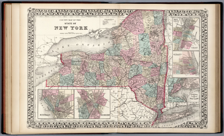
Mitchell, Samuel Augustus Jr.
Full Title
County map of the State of New York. Drawn and Engraved by W.H. Gamble Philadelphia. Entered ... 1876 by S. Augustus Mitchell, . ... Washington. (with inset maps) Buffalo. Rochester. West Troy, Troy. Albany. Harbor and vicinity of New York.
Publisher
S.A. Mitchell Jr.
Author
Mitchell, Samuel Augustus Jr.
Full Title
New York and Brooklyn. Entered ... 1876 by S. Augustus Mitchell, . ... Washington. (inset map): Northern portion of New York City and County.
Publisher
S.A. Mitchell Jr.
Author
Mitchell, Samuel Augustus Jr.
Full Title
County map of the State of Pennsylvania. Drawn and Engraved by W.H. Gamble Philadelphia. Entered ... 1876 by S. Augustus Mitchell, . ... Washington. (with four inset maps): Harrisburg, Williamsport, Erie, and Scranton.
Publisher
S.A. Mitchell Jr.
|