Browse All

1878 Germany, Austria, and Switzerland. World Atlas Germany, Austria, and Switzerland. Drawn … |

1878 France. World Atlas France. (inset) Corsica. |

1878 Spain and Portugal. World Atlas Spain and Portugal. (inset) Gibraltar. |

1878 Russia World Atlas Russia. |

1878 Vicinity of the Black Sea. World Atlas Gray's New Map of the Countries Surround … |

1878 Asia World Atlas Asia. |

1878 Africa. World Atlas Africa. (inset) Island of St. Helena. (i … |

1878 Australia. World Atlas Australia. |

1878 Palestine. World Atlas Palestine. (inset) Arabia Petraea. |

1878 Historical Maps of the United States. World Atlas Gray's Historical Maps of the United Sta … |

1878 Geological Map of the United States. World Atlas Gray's Geological Map of the United Stat … |

1878 Climatological Map of the United States. World Atlas Climatological Map of the United States … |

1878 Gray's Botanical and Zoological Maps of … World Atlas Gray's Botanical and Zoological Maps of … |

1878 Richmond, Virginia. World Atlas Map of Richmond, Henrico County, Virgini … |

1878 Edinburg, Virginia. World Atlas Edinburg, Shenandoah County, Virginia. |

1878 Woodstock, Virginia. World Atlas Woodstock, Shenandoah County, Virginia. |

1878 Mt. Jackson and New Market, Virginia. World Atlas Mt. Jackson, Shenandoah County, Virginia … |

1878 Luray, Virginia World Atlas Luray, Page County, Virginia. |

1878 Newtown, Virginia. World Atlas Newtown, (Newtown-Stephenburgh P.O.), Fr … |
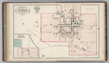
1878 Leesburg, Virginia. World Atlas Gray's New Map of Leesburg, Loudoun Co., … |

1878 Strasburg, Virginia. World Atlas Strasburg, Shenandoah County, Virginia. |

1878 Orange Court House, Virginia. World Atlas Map of Orange Court House, Orange County … |

1878 Culpepper, Virginia. World Atlas Gray's New Map of Culpepper, Culpepper C … |

1878 Gordonsville and Harrisonburg, Virginia. World Atlas Gray's New Map of Gordonsville, Orange C … |

1878 Louisiana. World Atlas Lousiana. |

1878 Western Hemisphere. State Atlas Western Hemisphere. (Compiled and publis … |

1878 Eastern Hemisphere. State Atlas Eastern Hemisphere. (Compiled and publis … |

1878 Map of Wisconsin showing congressional a … State Atlas Map of Wisconsin showing congressional a … |

1878 Map of Wisconsin showing senatorial dist … State Atlas Map of Wisconsin showing senatorial dist … |

1878 United States Census maps, 1870. State Atlas United States Census maps, 1870. Density … |

1878 United States vitality maps. Compiled fr … State Atlas United States vitality maps. Compiled fr … |

1878 Geological map of Wisconsin. State Atlas Geological map of Wisconsin. Compiled by … |

1878 New rail road map of the United States. State Atlas New rail road map of the United States. … |

1878 Climatological map of Wisconsin. State Atlas Climatological map of Wisconsin. Compile … |

1878 Products raised in 1870. Wheat. Dairy Pr … State Atlas These maps show amount of products raise … |

1878 Products raised in 1870. Hay. Tobacco. C … State Atlas These maps show amount of products raise … |

1878 Map of Wisconsin, showing assembly distr … State Atlas Map of Wisconsin, showing assembly distr … |

1878 Map of the State of Wisconsin. State Atlas Map of the State of Wisconsin, compiled … |

1878 Map of Walworth County, State of Wiscons … State Atlas Map of Walworth County, State of Wiscons … |

1878 Map of Milwaukee County, State of Wiscon … State Atlas Map of Milwaukee County, State of Wiscon … |

1878 Map of the City of Milwaukee, Milwaukee … State Atlas Map of the City of Milwaukee, Milwaukee … |

1878 Plan of Jefferson. Kenosha. State Atlas Plan of Jefferson, county seat of Jeffer … |

1878 Whitewater, Elkhorn and Geneva. State Atlas Whitewater. (with) Elkhorn, county seat … |

1878 Map of Waukesha County, State of Wiscons … State Atlas Map of Waukesha County, State of Wiscons … |

1878 Waukesha, Oconomowoc and Pewaukee, Wauke … State Atlas Waukesha, county seat of Waukesha Co. (w … |

1878 Map of Washington and Ozaukee counties, … State Atlas Map of Washington and Ozaukee counties, … |

1878 West Bend, Port Washington, Hartford and … State Atlas West Bend, county seat of Washington Co. … |

1878 Map of Dodge County, State of Wisconsin. State Atlas Map of Dodge County, State of Wisconsin. … |

1878 Map of Jefferson County, State of Wiscon … State Atlas Map of Jefferson County, State of Wiscon … |

1878 Watertown, Dodge & Jefferson cos. State Atlas Watertown, Dodge & Jefferson cos. (Compi … |