Browse All

1882 Township 29 South Range 4 West, Sedgwick … County Atlas Township 29 South Range 4 West. |

1882 Township 29 South Range 3 West, Sedgwick … County Atlas Township 29 South Range 3 West. |

1882 (Sheet 2). Western Palestine Natural Dra … National Atlas (Sheet 2). Map of Western Palestine from … |

1882 (Sheet 3). Western Palestine Natural Dra … National Atlas (Sheet 3). Western Palestine from Survey … |

1882 (Sheet 4). Western Palestine Natural Dra … National Atlas (Sheet 4). Map of Western Palestine from … |

1882 (Sheet 5). Western Palestine Natural Dra … National Atlas (Sheet 5). Map of Western Palestine from … |

1882 (Sheet 6). Western Palestine Natural Dra … National Atlas (Sheet 6). Map of Western Palestine from … |

1882 Scotland to Illustrate the Political Con … Statistical Atlas Scotland to Illustrate the Political Con … |

1882 Ireland to Illustrate the Political Cond … Statistical Atlas Ireland to Illustrate the Political Cond … |

1882 (Sheet 1). Western Palestine Natural Dra … National Atlas (Sheet 1). Map of Western Palestine from … |

1882 Franklin County, Indiana. County Atlas Map of Franklin County. |

1882 Brookville, Indiana. County Atlas Brookville. |

1882 Cedar Grove Formerly Rochester, Pepperto … County Atlas Cedar Grove Formerly Rochester, Pepperto … |

1882 Metamora Township, Franklin County, Indi … County Atlas Map of Metamora Township. Metamora. St. … |

1882 Brookville Township, Franklin County, In … County Atlas Map of Brookville Township, Franklin Cou … |

1882 Springfield Township, Franklin County, I … County Atlas Map of Springfield Township. |

1882 Bath Township and Fairfield Township, Fr … County Atlas Map of Bath Township. Map of Fairfield T … |

1882 Blooming Grove Township, Franklin County … County Atlas Map of Blooming Grove Township. Blooming … |

1882 Laurel Township, Franklin County, Indian … County Atlas Map of Laurel Township. |

1882 Posey Township, Franklin County, Indiana … County Atlas Map of Posey Township. Andersonville (Fo … |

1882 Laurel, Indiana. County Atlas Laurel. |

1882 Salt Creek Township, Franklin County, In … County Atlas Map of Salt Creek Township. |

1882 Ray Township. Oldenburg. Enochsburg. Hun … County Atlas Map of Ray Township. Oldenburg. Enochsbu … |

1882 Butler Township. County Atlas Map of Butler Township. |

1882 Highland Township. Village and Catholic … County Atlas Map of Highland Township. Village and Ca … |

1882 Map of White Water Township, Franklin Co … County Atlas Map of White Water Township. |
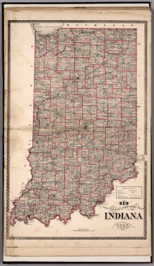
1882 Sectional and Township Map of Indiana. 1 … County Atlas Sectional and Township Map of Indiana. 1 … |

1882 New Railroad Map of the United States. County Atlas New Railroad Map of the United States. |

1882 Western Hemisphere. Eastern Hemisphere. County Atlas Western Hemisphere. Eastern Hemisphere. |

1882 Geological Map Of The Western Part Of Th … Geologic Atlas Geological Map Of The Western Part Of Th … |

1882 Sketch Map ... showing The Faults of the … Geologic Atlas Sketch Map of the Western Part of the Pl … |

1882 Map Of The Uinkaret Plateau. North Half. … Geologic Atlas Map Of The Uinkaret Plateau. North Half. … |

1882 Map Of The Uinkaret Plateau. South Half. Geologic Atlas Map Of The Uinkaret Plateau. South Half. … |

1882 Geologic Map Of The Southern Part Of The … Geologic Atlas Geologic Map Of The Southern Part Of The … |

1882 Geologic Map Of The Southern Part Of The … Geologic Atlas Geologic Map Of The Southern Part Of The … |

1882 Geologic Map Of The Southern Part Of The … Geologic Atlas Geologic Map Of The Southern Part Of The … |

1882 Geologic Map Of The Southern Part Of The … Geologic Atlas Geologic Map Of The Southern Part Of The … |

1882 Geologic Map Showing The South-Western P … Geologic Atlas Geologic Map Showing The South-Western P … |

1882 Geologic Map Of The Mesozoic Terraces Of … Geologic Atlas Geologic Map Of The Mesozoic Terraces Of … |

1882 Geologic Map Showing The Kanab, Paria An … Geologic Atlas Geologic Map Showing The Kanab, Paria An … |

1882 Geologic Map Of The Colorado Plateau And … Geologic Atlas Geologic Map Of The Colorado Plateau And … |

1882 Planisphere. World Atlas Planisphere. Atlas St. Cyr. Furne, Jouve … |

1882 Europe Physique. World Atlas Europe Physique. Atlas St. Cyr. Furne, J … |

1882 Europe Politique. World Atlas Europe Politique. Atlas St. Cyr. Furne, … |

1882 Carte Politique de L'Europe Centrale. World Atlas Carte Politique de L'Europe Centrale. At … |

1882 Europe Centrale (Partie Occidentale). World Atlas Europe Centrale (Partie Occidentale). At … |

1882 Europe Centrale (Partie Centrale). World Atlas Europe Centrale (Partie Centrale). Atlas … |

1882 Europe Centrale (Partie Orientale). World Atlas Europe Centrale (Partie Orientale). Atla … |

1882 Carte Geologique de la Region Francaise. World Atlas Carte Geologique de la Region Francaise. … |

1882 Carte Physique de la Region Francaise. World Atlas Carte Physique de la Region Francaise. A … |