|
Author
Edwards, John P.
Full Title
Township 29 South Range 4 West.
Publisher
John P. Edwards
Author
Edwards, John P.
Full Title
Township 29 South Range 3 West.
Publisher
John P. Edwards
Author
[Conder, C.R. (Claude Reignier), Kitchener, H.R. (Horatio Herbert)]
Full Title
(Sheet 2). Map of Western Palestine from Surveys Conducted for The Committee of the Palestine Exploration Fund ... Reduced from the One-Inch Map ... Special Edition Illustrating the Divisions of the Natural Drainage and the Mountain Ranges According to "An Introduction to the Survey of Western Palestine by Trelawney Saunders.
Publisher
Committee of the Palestine Exploration Fund
Author
[Conder, C.R. (Claude Reignier), Kitchener, H.R. (Horatio Herbert)]
Full Title
(Sheet 3). Western Palestine from Surveys Conducted for The Committee of the Palestine Exploration Fund ... Reduced from the One-Inch Map ... Special Edition Illustrating the Divisions of the Natural Drainage and the Mountain Ranges According to "An Introduction to the Survey of Western Palestine by Trelawney Saunders.
Publisher
Committee of the Palestine Exploration Fund
Author
[Conder, C.R. (Claude Reignier), Kitchener, H.R. (Horatio Herbert)]
Full Title
(Sheet 4). Map of Western Palestine from Surveys Conducted for The Committee of the Palestine Exploration Fund ... Reduced from the One-Inch Map ... Special Edition Illustrating the Divisions of the Natural Drainage and the Mountain Ranges According to "An Introduction to the Survey of Western Palestine by Trelawney Saunders.
Publisher
Committee of the Palestine Exploration Fund
Author
[Conder, C.R. (Claude Reignier), Kitchener, H.R. (Horatio Herbert)]
Full Title
(Sheet 5). Map of Western Palestine from Surveys Conducted for The Committee of the Palestine Exploration Fund ... Reduced from the One-Inch Map ... Special Edition Illustrating the Divisions of the Natural Drainage and the Mountain Ranges According to "An Introduction to the Survey of Western Palestine by Trelawney Saunders.
Publisher
Committee of the Palestine Exploration Fund
Author
[Conder, C.R. (Claude Reignier), Kitchener, H.R. (Horatio Herbert)]
Full Title
(Sheet 6). Map of Western Palestine from Surveys Conducted for The Committee of the Palestine Exploration Fund ... Reduced from the One-Inch Map ... Special Edition Illustrating the Divisions of the Natural Drainage and the Mountain Ranges According to "An Introduction to the Survey of Western Palestine by Trelawney Saunders.
Publisher
Committee of the Palestine Exploration Fund
Author
Bevan, G. Phillips
Full Title
Scotland to Illustrate the Political Condition of the Country by G. Phillips Bevan, F.S.S., F.G.S., 1881.
Publisher
W. &. A.K. Johnston
Author
Bevan, G. Phillips
Full Title
Ireland to Illustrate the Political Condition of the Country by G. Phillips Bevan, F.S.S., F.G.S., 1881.
Publisher
W. &. A.K. Johnston
Author
[Conder, C.R. (Claude Reignier), Kitchener, H.R. (Horatio Herbert)]
Full Title
(Sheet 1). Map of Western Palestine from Surveys Conducted for The Committee of the Palestine Exploration Fund ... Reduced from the One-Inch Map ... Special Edition Illustrating the Divisions of the Natural Drainage and the Mountain Ranges According to "An Introduction to the Survey of Western Palestine by Trelawney Saunders.
Publisher
Committee of the Palestine Exploration Fund
Author
Beers, J.H. & Co.
Full Title
Map of Franklin County.
Publisher
J.H. Beers
Author
Beers, J.H. & Co.
Full Title
Brookville.
Publisher
J.H. Beers
Author
Beers, J.H. & Co.
Full Title
Cedar Grove Formerly Rochester, Peppertown, New Trenton, South Gate, Scipio, Drewersburg (Laid Out as Edinburg).
Publisher
J.H. Beers
Author
Beers, J.H. & Co.
Full Title
Map of Metamora Township. Metamora. St. Mary's, Haymond P.O. St. Philomena, Oak Forest P.O.
Publisher
J.H. Beers
Author
Beers, J.H. & Co.
Full Title
Map of Brookville Township, Franklin County, Indiana. Fairfield. Union, Whitcomb P.O., Indiana.
Publisher
J.H. Beers
Author
Beers, J.H. & Co.
Full Title
Map of Springfield Township.
Publisher
J.H. Beers
Author
Beers, J.H. & Co.
Full Title
Map of Bath Township. Map of Fairfield Township.
Publisher
J.H. Beers
Author
Beers, J.H. & Co.
Full Title
Map of Blooming Grove Township. Blooming Grove. Mixerville.
Publisher
J.H. Beers
Author
Beers, J.H. & Co.
Full Title
Map of Laurel Township.
Publisher
J.H. Beers
Author
Beers, J.H. & Co.
Full Title
Map of Posey Township. Andersonville (Formerly Ceylon), Mt. Carmel, Buena Vista, Hamburg, and Palestine.
Publisher
J.H. Beers
Author
Beers, J.H. & Co.
Full Title
Laurel.
Publisher
J.H. Beers
Author
Beers, J.H. & Co.
Full Title
Map of Salt Creek Township.
Publisher
J.H. Beers
Author
Beers, J.H. & Co.
Full Title
Map of Ray Township. Oldenburg. Enochsburg. Huntersville.
Publisher
J.H. Beers
Author
Beers, J.H. & Co.
Full Title
Map of Butler Township.
Publisher
J.H. Beers
Author
Beers, J.H. & Co.
Full Title
Map of Highland Township. Village and Catholic Church of St. Peter.
Publisher
J.H. Beers
Author
Beers, J.H. & Co.
Full Title
Map of White Water Township.
Publisher
J.H. Beers
Author
Beers, J.H. & Co.
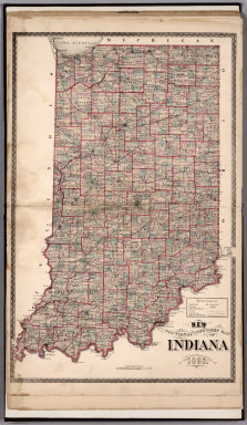
Full Title
Sectional and Township Map of Indiana. 1882.
Publisher
J.H. Beers
Author
Beers, J.H. & Co.
Full Title
New Railroad Map of the United States.
Publisher
J.H. Beers
Author
Beers, J.H. & Co.
Full Title
Western Hemisphere. Eastern Hemisphere.
Publisher
J.H. Beers
Author
Dutton, Clarence E. (Clarence Edward), 1841-1912
Full Title
Geological Map Of The Western Part Of The Plauteau Province. Sheet II. J.H. Renshawe, Del. Geology by C.E. Dutton, Geologist-in-Charge. Julius Bien, lith. N.Y. U.S. Geological Survey, Geology of the Grand Canon District.
Publisher
Bien, Julius & Co.
Author
Dutton, Clarence E. (Clarence Edward), 1841-1912
Full Title
Sketch Map of the Western Part of the Plateau Province showing The Faults of the Grand Canon District and High Plateaus. Sheet III. Julius Bien, lith. N.Y. C.E. Dutton, Geologist-in-Charge. U.S. Geological Survey, Geology of the Grand Canon District.
Publisher
Bien, Julius & Co.
Author
Dutton, Clarence E. (Clarence Edward), 1841-1912
Full Title
Map Of The Uinkaret Plateau. North Half. Atlas Sheet VII. Geology by C.E. Dutton. Julius Bien & Co. lith. U.S. Geological Survey, Geology of the Grand Canon District.
Publisher
Bien, Julius & Co.
Author
Dutton, Clarence E. (Clarence Edward), 1841-1912
Full Title
Map Of The Uinkaret Plateau. South Half. Atlas Sheet VIII. Geology by C.E. Dutton. Julius Bien & Co. lith. U.S. Geological Survey, Geology of the Grand Canon District.
Publisher
Bien, Julius & Co.
Author
Dutton, Clarence E. (Clarence Edward), 1841-1912
Full Title
Geologic Map Of The Southern Part Of The Kaibab Plateau. [Part I. North-Western Sheet.] Atlas Sheet XI. Geology by C.E. Dutton. Julius Bien & Co. lith. U.S. Geological Survey, Geology of the Grand Canon District.
Publisher
Bien, Julius & Co.
Author
Dutton, Clarence E. (Clarence Edward), 1841-1912
Full Title
Geologic Map Of The Southern Part Of The Kaibab Plateau. [Part II. North-Eastern Sheet.] Atlas Sheet XII. Geology by C.E. Dutton. Julius Bien & Co. lith. U.S. Geological Survey, Geology of the Grand Canon District.
Publisher
Bien, Julius & Co.
Author
Dutton, Clarence E. (Clarence Edward), 1841-1912
Full Title
Geologic Map Of The Southern Part Of The Kaibab Plateau. [Part III. South-Western Sheet.] Atlas Sheet XIII. Geology by C.E. Dutton. Julius Bien & Co. lith. U.S. Geological Survey, Geology of the Grand Canon District.
Publisher
Bien, Julius & Co.
Author
Dutton, Clarence E. (Clarence Edward), 1841-1912
Full Title
Geologic Map Of The Southern Part Of The Kaibab Plateau. [Part IV. South-Eastern Sheet.] Atlas Sheet XIV. Geology by C.E. Dutton. Julius Bien & Co. lith. U.S. Geological Survey, Geology of the Grand Canon District.
Publisher
Bien, Julius & Co.
Author
Dutton, Clarence E. (Clarence Edward), 1841-1912
Full Title
Geologic Map Showing The South-Western Portion Of The Mesozoic Terraces And The Vicinity Of The Hurricane Fault. Atlas Sheet XX. Geology by C.E. Dutton. Julius Bien & Co. lith. U.S. Geological Survey, Geology of the Grand Canon District.
Publisher
Bien, Julius & Co.
Author
Dutton, Clarence E. (Clarence Edward), 1841-1912
Full Title
Geologic Map Of The Mesozoic Terraces Of The Grand Canon District And The Southern Portions Of The High Plateaus. Atlas Sheet XXI. Geology by C.E. Dutton. Julius Bien & Co. lith. U.S. Geological Survey, Geology of the Grand Canon District.
Publisher
Bien, Julius & Co.
Author
Dutton, Clarence E. (Clarence Edward), 1841-1912
Full Title
Geologic Map Showing The Kanab, Paria And Marble Canon Platforms. Atlas Sheet XXII. Geology by C.E. Dutton. Julius Bien & Co. lith. U.S. Geological Survey, Geology of the Grand Canon District.
Publisher
Bien, Julius & Co.
Author
Dutton, Clarence E. (Clarence Edward), 1841-1912
Full Title
Geologic Map Of The Colorado Plateau And San Francisco Mountains. Atlas Sheet XXIII. Geology by C.E. Dutton. Julius Bien & Co. lith. U.S. Geological Survey, Geology of the Grand Canon District.
Publisher
Bien, Julius & Co.
Author
Jouvet et Cie.
Full Title
Planisphere. Atlas St. Cyr. Furne, Jouvet et Cie. Editeurs. Imp. Lemercier et Cie. Paris. Grave par J. Geisendorfer, 12 r. de l'Abbaye, Paris. (1882)
Publisher
Jouvet et Cie
Author
Jouvet et Cie.
Full Title
Europe Physique. Atlas St. Cyr. Furne, Jouvet et Cie. Editeurs. Imp. Lemercier et Cie. Paris. La lettre gravee par J. Geisendorfer, 12 r. de l'Abbaye, Paris. (1882)
Publisher
Jouvet et Cie
Author
Jouvet et Cie.
Full Title
Europe Politique. Atlas St. Cyr. Furne, Jouvet et Cie. Editeurs. Imp. Lemercier et Cie. Paris. La lettre gravee par J. Geisendorfer, 12 r. de l'Abbaye, Paris. (1882)
Publisher
Jouvet et Cie
Author
Jouvet et Cie.
Full Title
Carte Politique de L'Europe Centrale. Atlas St. Cyr. Furne, Jouvet et Cie. Editeurs. Imp. Monrocq. Grave par J. Geisendorfer, 12 r. de l'Abbaye, Paris. (1882)
Publisher
Jouvet et Cie
Author
Jouvet et Cie.
Full Title
Europe Centrale (Partie Occidentale). Atlas St. Cyr. Furne, Jouvet et Cie. Editeurs. Imp. Lemercier et Cie. Paris. La lettre gravee par J. Geisendorfer, 12 r. de l'Abbaye, Paris. (1882)
Publisher
Jouvet et Cie
Author
Jouvet et Cie.
Full Title
Europe Centrale (Partie Centrale). Atlas St. Cyr. Fleur et Dubail. Furne, Jouvet et Cie. Editeurs. Imp. Lemercier et Cie. Paris. Grave par Erhard, 12 r. Duguay-Trouin. Corrige par J. Geisendorfer, 12 r. de l'Abbaye. (1882)
Publisher
Jouvet et Cie
Author
Jouvet et Cie.
Full Title
Europe Centrale (Partie Orientale). Atlas St. Cyr. E. Dubail. Furne, Jouvet et Cie. Editeurs. Imp. Lemercier et Cie. Paris. Grave par Erhard, 12 R. Duguay-Trouin. Corrige par J. Geisendorfer, 12 r. de l'Abbaye. (1882)
Publisher
Jouvet et Cie
Author
Jouvet et Cie.
Full Title
Carte Geologique de la Region Francaise. Atlas St. Cyr. G. Hue. Furne, Jouvet et Cie. Editeurs. Imp. Lemercier et Cie. Paris. (1882)
Publisher
Jouvet et Cie
Author
Jouvet et Cie.
Full Title
Carte Physique de la Region Francaise. Atlas St. Cyr. Furne, Jouvet et Cie. Editeurs. Imp. Lemercier et Cie. Paris. Grave par J. Geisendorfer, 12 r. de l'Abbaye, Paris. (1882)
Publisher
Jouvet et Cie
|


![Geologic Map Of The Southern Part Of The Kaibab Plateau. [Part I. North-Western Sheet.]](https://www.davidrumsey.com/rumsey/Size3/D0009/00093151.jpg)
![Geologic Map Of The Southern Part Of The Kaibab Plateau. [Part II. North-Eastern Sheet.]](https://www.davidrumsey.com/rumsey/Size3/D0009/00093152.jpg)
![Geologic Map Of The Southern Part Of The Kaibab Plateau. [Part III. South-Western Sheet.]](https://www.davidrumsey.com/rumsey/Size3/D0009/00093153.jpg)
![Geologic Map Of The Southern Part Of The Kaibab Plateau. [Part IV. South-Eastern Sheet.]](https://www.davidrumsey.com/rumsey/Size3/D0009/00093154.jpg)


