Browse All

1922 Relative Frequency of Precipitation. Atl … National Atlas Relative Frequency of Precipitation for … |

1922 (Precipitation Maps). Atlas of American … National Atlas ... Periods of 30 Days or More without 0 … |

1922 Annual Snowfall. Atlas of American Agric … National Atlas Average Annual Snowfall in Inches, Unmel … |

1922 (Hail, Fog, Thunderstorms, Clear, Cloudy … National Atlas Average Number of Days (Hail, Fog, Thund … |

1922 Relative Humidity, Vapor Pressure, Wet B … National Atlas (Relative Humidity, Vapor Pressure, Wet … |

1922 Warm Season Evaporation. Atlas of Americ … National Atlas Warm Season Evaporation in Inches. Atlas … |

1935 Areas of Soil Surveys. Atlas of American … National Atlas Areas Covered by the Soil Survey. Soils, … |
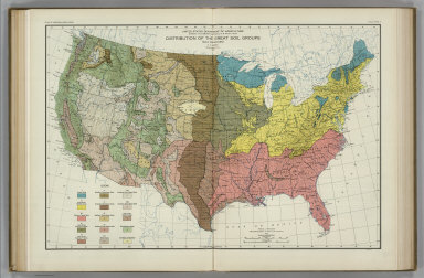
1931 Great Soil Groups. Atlas of American Agr … National Atlas Distribution of the Great Soil Groups. S … |

1931 Parent Materials of Soils. Atlas of Amer … National Atlas Distribution of Parent Materials of Soil … |

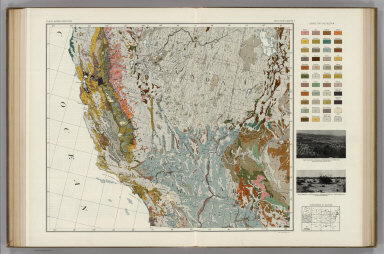
1931 Soil Map of the United States, Section 1 … National Atlas Soil Map of the United States by Curtis … |

1931 Soils without Normal Profiles. Atlas of … National Atlas Distribution of Soils without Normal Pro … |

1923 Natural Vegetation. Atlas of American Ag … National Atlas Natural Vegetation. Grassland and Desert … |

1924 Grassland Divisions. Land in Crops, 1919 … National Atlas Grassland Divisions. Land in Crops, 1919 … |

1928 Monthly Temperature Maps: March. April. … National Atlas (Monthly Temperature Maps:) March. April … |

1928 Monthly Temperature Maps: May. June. Atl … National Atlas (Monthly Temperature Maps:) May. June. A … |

1928 Monthly Temperature Maps: July. August. … National Atlas (Monthly Temperature Maps:) July. August … |

1928 Monthly Temperature Maps: September. Oct … National Atlas (Monthly Temperature Maps:) September. O … |

1928 Monthly Temperature Maps: November. Dece … National Atlas (Monthly Temperature Maps:) November. De … |

1916 Location of Meteorological Stations. Atl … National Atlas Location of Meteorological Stations. Fig … |

1922 Monthly (May, June, July) Precipitation. … National Atlas Average Monthly (May, June, July) Precip … |

1931 Soil Map of the United States, Section 2 … National Atlas Soil Map of the United States by Curtis … |

1931 Soil Map of the United States, Section 3 … National Atlas Soil Map of the United States by Curtis … |

1931 Soil Map of the United States, Section 4 … National Atlas Soil Map of the United States by Curtis … |
1931 Soil Map of the United States, Section 5 … National Atlas Soil Map of the United States by Curtis … |

1931 Soil Map of the United States, Section 6 … National Atlas Soil Map of the United States by Curtis … |

1931 Soil Map of the United States, Section 7 … National Atlas Soil Map of the United States by Curtis … |

1931 Soil Map of the United States, Section 8 … National Atlas Soil Map of the United States by Curtis … |

1931 Soil Map of the United States, Section 9 … National Atlas Soil Map of the United States by Curtis … |

1931 Soil Map of the United States, Section 1 … National Atlas Soil Map of the United States by Curtis … |

1931 Soil Map of the United States, Section 1 … National Atlas Soil Map of the United States by Curtis … |

1931 Soil Map of the United States, Section 1 … National Atlas Soil Map of the United States by Curtis … |

1936 Basin du Pacifique. World Atlas Planisphere. Feuille 1. Basin du Pacifiq … |
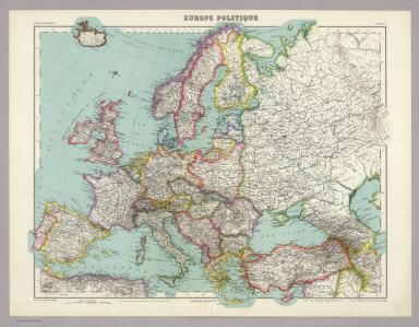
1936 Europe Politique. World Atlas Europe Politique. Carte 5. Dessine par T … |

1936 Italie. World Atlas Italie. Carte 25. Dresse par Th. Weinreb … |

1936 Inde N.-O. et Afganistan. World Atlas Inde N.-O. et Afganistan. Carte 45. Dres … |

1936 Inde N.-E. et Tibet. World Atlas Inde N.-E. et Tibet. Carte 46. Dresse pa … |

1936 Indochine. World Atlas Indochine. Carte 48. Dresse par E. Giffa … |

1936 China, Flle. Nord. World Atlas China, Flle. Nord. Carte 49. Dresse par … |

1936 Afrique du Sud. World Atlas Afrique du Sud. Carte 56. Dresse par Mar … |

1936 Amerique de Sud Politique. World Atlas Amerique de Sud Politique. Carte 71. Dre … |