Who What Where WhenREMOVEWHO
WHEN
|
Full Title
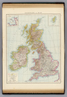
British Isles. (with) The Channel Islands. (with) The Shetland Islands. (Published at the office of "The Times," London, 1895)
Publisher
The Times
Author
[Bartholomew, J. G. (John George), 1860-1920, John Bartholomew & Co.]
Full Title
British Isles -- bathy-orographical. The Edinburgh Geographical Institute, John Bartholomew & Co. "The Times" atlas. (London: The Times, 1922)
Publisher
The Times
Author
[Bartholomew, J. G. (John George), 1860-1920, John Bartholomew & Co.]
Full Title
British Isles - vegetation & climate. The Edinburgh Geographical Institute, John Bartholomew & Co. "The Times" atlas. (London: The Times, 1922)
Publisher
The Times
Full Title
Grossbritannien und Irland. (with) Die Canal Inseln. (with) Die Shetland Inseln. (Richard Andree. Herausgegeben von der Geographischen Anstalt von Velhagen & Klasing in Leipzig. 1881)
Publisher
Velhagen & Klasing
Author
Moll, Herman, d. 1732
Full Title
A general map of Great Britain and Ireland, with part of Germany, Holland, Flanders, France &c. Agreeable to modern history. By H. Moll Geographer. (with Farro, Schetland and Orkney islands). (Printed for Tho: Bowles next ye Chapter House in St. Pauls Church Yard, & John Bowles at the Black Horse in Cornhill, London 1736?)
Publisher
Thos. Bowles and John Bowles
Full Title
British Islands. N. & S.S. Jocelyn Sc. (Boston: Published by Richardson & Lord. 1820)
Publisher
Richardson & Lord
Author
Clouet, J. B. L. (Jean-Baptiste Louis), b. 1730
Full Title
Des Isles Britanniques. (1787)
Publisher
Mondhare et Jean
Full Title
British Isles. (with) Shetland Isles. (Boston: Hilliard, Gray, Little and Wilkins, 1826)
Publisher
Hilliard, Gray, Little and Wilkins
Full Title
Die Brittischen Inseln. England, Schottland, Ireland. (Efter Stielers Hand-Atlas. Stockholm, J.L. Brudin, 1852)
Publisher
J.L. Brudin
Full Title
(La Grande-Bretagne. A Lyon, Chez Jean-Marie Bruyset, Pere & Fils. M.DCC.LXXXIV)
Publisher
Jean-Marie Bruyset
Author
Fenner, Rest.
Full Title
Britannicae Insulae. Fenner Sc., Paternoster Row. (London, Joseph Thomas, 1835)
Publisher
Joseph Thomas
Author
[Stieler, Adolf, Stulpnagel, F.v.]
Full Title
No. XVII. Stieler's Hand-Atlas (No. 15a.) Die Brittischen Inseln und Die Nord-See.
Publisher
Justus Perthes
Author
[Forbes, Edward, 1815-1854, Johnston, Alexander Keith, 1804-1871]
Full Title
Geological & palaeontological map of the British Islands. By A.K. Johnston, F.R.G.S. From the sketches & notes of Professor Edward Forbes, F.R.S. of Kings College London & of the Government School of Mines, President of the Geological Society. Engraved by W. & A.K. Johnston. William Blackwood & Sons, Edinburgh & London. 1st March 1854, (1856)
Publisher
William Blackwood & Sons
Author
[Forbes, Edward, 1815-1854, Johnston, Alexander Keith, 1804-1871]
Full Title
Palaeontological map (British Islands. By A.K. Johnston, F.R.G.S. From the sketches & notes of Professor Edward Forbes, F.R.S. of Kings College London & of the Government School of Mines, President of the Geological Society). Engraved by W. & A.K. Johnston. William Blackwood & Sons, Edinburgh & London. 1st March 1854, (1856)
Publisher
William Blackwood & Sons
Author
[Forbes, Edward, 1815-1854, Johnston, Alexander Keith, 1804-1871]
Full Title
(Composite of) Geological & palaeontological map of the British Islands. By A.K. Johnston, F.R.G.S. From the sketches & notes of Professor Edward Forbes, F.R.S. of Kings College London & of the Government School of Mines, President of the Geological Society. Engraved by W. & A.K. Johnston. William Blackwood & Sons, Edinburgh & London. 1st March 1854, (1856)
Publisher
William Blackwood & Sons
Author
Debenham, Frank
Full Title
The British Isles. (Copyright) G.P. Ltd. (with inset).
Publisher
Simon and Schuster
Author
[Johnston, Alexander Keith, 1804-1871, Russell, J. Scott (John Scott), 1808-1882]
Full Title
Tidal chart of the British Seas. Showing the progress of the wave of high water, the hour of high water in Greenwich time at new and full moon; and the depth of the sea. Constructed under the direction of J. Scott Russell, Esqr., F.R.S., ED. by A.K. Johnston, F.R.G.S. Engraved by W. & A.K. Johnston. William Blackwood & Sons, Edinburgh & London. 1 Nov. 1854. (1856)
Publisher
William Blackwood & Sons
Author
Johnston, Alexander Keith, 1804-1871
Full Title
Hyetographic or rain map of Europe with an enlarged rain map of the British Isles by A.K. Johnston, F.R.S.E. Engraved by W. & A.K. Johnston. William Blackwood & Sons, Edinburgh & London. (1856)
Publisher
William Blackwood & Sons
Author
[Matthews-Northrup Division, J.W. Clement Co.]
Full Title
British Isles. Mercator Projection. Copyright, J.W. Clement Co., Matthews-Northrup Works, Buffalo, N.Y. (inset maps) London and Shetland Islands.
Publisher
World Publishing Company
Author
Rand McNally & Company
Full Title
Rand McNally Popular map of British Isles. Copyright by Rand McNally & Company, Chicago. Made in U.S.A.
Publisher
Rand McNally & Company
Author
[Johnston, Alexander Keith, 1804-1871, Kombst, Gustaf]
Full Title
Ethnographic map of Great Britain and Ireland, according to Dr. Gustaf Kombst ... by A.K. Johnston, F.R.G.S. Engraved & printed in colours by W. & A.K. Johnston, Edinburgh. William Blackwood & Sons, Edinburgh & London. (1856)
Publisher
William Blackwood & Sons
Author
[Geographisches Institut (Weimar, Germany), Kiepert, Heinrich, 1818-1899]
Full Title
Die Britischen Inseln, oder die Vereinigten Konigreich. (with) Die wichtigsten Fabrik-Districte im nordwestlichen England ... (with) Die wichtigsten Kohlen-Districte in Nordengland. (with Die Shetland Inseln). (with) Die Normannischen Inseln. Gezeichnet v. H. Kiepert. Gestochen v. E. Kratz.
Publisher
Weimar Geo Inst.
Author
[Stieler, Adolf, Petermann, A.]
Full Title
Stieler's Hand-Atlas ... No. 15a. Die Britischen Inseln und das Umliegende Meer. (insets) London. Crystall Palast. Helgoland. Rockall (View).
Publisher
Justus Perthes
Author
Stieler, Adolf
Full Title
Die Britischen Jnseln England, Schotland, Jreland. entw. v. Ad. St. 1816. verbessert v. neu gestochen 1823. Hasse sc. Weimar. Amerk, Hierzu 3. Special karten von England, Schotland u. Ireland, No. 15b, 15c, 15d. auf welchen man auch die Namen der ausgezeichneten Berge findet. (on upper right margin) Stielers Hand-Atlas No. 15. (to accompany) Hand-Atlas uber alle Theile der Erde, nach dem neuesten Zustande und uber das Weltgebaude. (insets) Umgebungen von London (no.1) ; Hafen von Portsmouth (no.2) ; Haf. v. Edinburgh (no.3).
Publisher
Justus Perthes
Author
Stieler, Adolf
Full Title
Stieler's Hand-Atlas No. 45. Die Britischen Inseln und das Umliegende Meer. (inset) London. Crystall-Palast. Helgoland. Rockall (view).
Publisher
Justus Perthus
Author
[Stieler, Adolf, Stulpnagel, F.v.]
Full Title
No. XVII. Stieler's Hand-Atlas (No. 15a.) Die Brittischen Inseln und Die Nord-See.
Publisher
Justus Perthes
Author
Bartholomew, J. G.
Full Title
British Isles, Comparative Value of Land, Comparative Density of Population
Publisher
George Newnes, Limited
Author
Bartholomew, J. G.
Full Title
British Isles - Industrial. Agricultural. Iron Industries. Textiles. Glass, Earthenware. &c. (Statistical Diagram) Occupations in the British Isles, 1901.
Publisher
George Newnes, Limited
Author
Johnston, A. Keith
Full Title
The Mountains, Table Lands, Plains & Valleys of the British Isles.
Publisher
William Blackwood & Sons
Author
Wilkinson, Robert
Full Title
Britain, or the United Kingdom of England, Scotland, & Ireland.
Publisher
Robert Wilkinson
Author
Wilkinson, Robert
Full Title
A New Map of Great Britain and Ireland.
Publisher
R. Wilkerson
Author
Wilkinson, Robert
Full Title
Britannicae Insulae ex Aevi Romani Monumentis.
Publisher
Robert Wilkinson
Author
Stieler, Adolf
Full Title
No. XVII. Stielers Hand-Atlas (No. 15). Die Brittischen Inseln, England, Schotland, Ireland.
Publisher
Justus Perthus
Author
Bradford, Thomas G.
Full Title
British Islands. (to accompany) A Comprehensive Atlas, Geographical, Historical & Commercial. By T.G. Bradford. William D. Ticknor, Boston. Wiley & Long, New-York. Entered ... 1835, by Thos. G. Bradford ... Massachusetts.
Publisher
[William D. Ticknor, Wiley & Long]
Author
Gray, O.W.
Full Title
British Isles. (inset) Shetland and Orkney Islands.
Publisher
Stedman & Brown
Author
Appleton, D. & Co.
Full Title
British Isles. Copyright 1891 by Appleton & Co.(to accompany) The Library Atlas Of Modern Geography ... New York, D. Appleton And Company 1892. (on upper margin) British Isles 13.
Publisher
D. Appleton & Co.
Author
Andriveau-Goujon, J.
Full Title
Carte des Iles Britanniques, comprenant l'Angleterre, l'Ecosse et l'Irlande. Publiee par J. Andriveau-Goujon, Rue du Bac, no. 17, Paris, 1845.
Publisher
J. Andriveau-Goujon
Author
Janvier, Jean
Full Title
Les Isles Britanniques comprenant les Royaumes d'Angleterre, d'Ecosse et d'Irlande, divises en grandes provinces. Dresses sur les observations astronomiques. Par le Sr. Janvier Geographe. A Paris, Chez Lattre Graveur, rue St. Jacques, a la Ville de Bordeaux. (178-?)
Publisher
Lattre & Delalain
Author
Society for the Diffusion of Useful Knowledge (Great Britain)
Full Title
The British Isles. Published under the superintendence of the Society for the Diffusion of Useful Knowledge, 59 Lincolns Inn Fields, April 1842, by Chapman & Hall 186 Strand. J. & C. Walker sculpt. (1844)
Publisher
Chapman and Hall
Author
[Murchison, Roderick Impey, Sir, 1792-1871, Society for the Diffusion of Useful Knowledge (Great Britain)]
Full Title
Geological map of England and Wales. Published under the superintendence of the Society for the Diffusion of Useful Knowledge. 1843. Arranged by Roderick Impey Murchison ... S.P. Woodward del. Col(oure)d. by T. Malby. J. & C. Walker sculpt. Published by Chapman & Hall 186 Strand Decr. 15th. 1843. (1844)
Publisher
Chapman and Hall
Author
[Andriveau-Goujon, J., Soulier, E.]
Full Title
Iles Britanniques. (inset) Iles Shetland. Atlas Elementaire Simplifie. Publie par J. Andriveau-Goujon. A Paris, chez Andriveau-Goujon, Editeur, Rue du Bac, No. 17.
Publisher
Andriveau-Goujon
Author
Polish Army Topography Service
Full Title
The British Isles. Pergamon World Atlas. Pergamon Press, Ltd. & P.W.N. Poland 1964. Sluzba Topograficzna W.P.
Publisher
Pergamon Press
Author
Gray, Ormando Willis
Full Title
Gray's Atlas Map of Great Britain and Ireland.
Publisher
Stedman, Brown & Lyon
Author
[Union Atlas Co., Warner & Beers]
Full Title
Map of the British Isles. (Union Atlas Co., Warner & Beers, Proprietors. Lakeside Building Cor: of Clark & Adams Sts. Chicago. 1876. Entered ... 1876 by Warner & Beers ... Washington D.C.)
Publisher
Warner & Beers
Author
Duval, Henri
Full Title
Atlas Universel. Tableau historique et geographique des Iles Britanniques. ... Par Henri Duval, Chevalier de la Legion d'honneur, Professeur d'histoire, de geographie, de belles-lettres, &. Paris (1834), Chez l'Auteur, rue de la Chaussee d'Antin, No.15... Johanneau, Rue du Coq. No. 8 bis. ,,, Ate. Foucher.
Publisher
L. Houbloup
Author
Rocque, John
Full Title
(A map of the Kingdom of Ireland, divided into provinces, counties and baronies. Southern section. Shewing the archbishopricks, bishopricks, cities, boroughs, market towns, villages, barracks, mountains, lakes, bays, rivers, bridges, ferries, passes, also the great, the branch & the by post roads together with the inland navigation, by J. Rocque, Chorographer to His Majesty). London, printed for Robt. Sayer, opposite Fetter Lane, Fleet Street, (1790?)
Publisher
Robert Sayer
Author
Rocque, John
Full Title
(Composite map) A map of the Kingdom of Ireland, divided into provinces, counties and baronies. Southern section. Shewing the archbishopricks, bishopricks, cities, boroughs, market towns, villages, barracks, mountains, lakes, bays, rivers, bridges, ferries, passes, also the great, the branch & the by post roads together with the inland navigation, by J. Rocque, Chorographer to His Majesty. London, printed for Robt. Sayer, opposite Fetter Lane, Fleet Street, (1790?)
Publisher
Robert Sayer
Author
Pinkerton, John, 1758-1826
Full Title
British Isles. (with inset map) Shetland Islands. Neele sc. 352 Strand London: published Novr. 15th. 1812, by Cadell & Davies, Strand, & Longman, Hurst, Rees, Orme, & Brown, Paternoster Row.
Publisher
[Cadell and Davies, Longman, Hurst, Rees, Orme, and Brown]
Author
Vivien de St Martin, L.
Full Title
Carte des Iles Britanniques, formees de trois grandes parties: L'Irlande, L'Ecosse, et L'Angleterre; avec leurs Divisions en Comtes. Par L. Vivien, Geographe. 1824. Grave par Giraldon Bovinet. A Paris. Chez Menard et Desenne, Rue Git le Coeur, No. 8. Iere Feuille.
Publisher
Vivien de St Martin, L.
Author
Vivien de St Martin, L.
Full Title
Carte des Iles Britanniques, formees de trois grandes parties: L'Irlande, L'Ecosse, et L'Angleterre; avec leurs Divisions en Comtes. Par L. Vivien, Geographe. 1824. Grave par Giraldon Bovinet. A Paris. Chez Menard et Desenne, Rue Git le Coeur, No. 8. 2eme Feuille.
Publisher
Vivien de St Martin, L.
|