Who What Where When |
REFINE
Browse All : Atlas Map of California and San Diego Bay (Calif.)
1-2 of 2
Author
Vancouver, George, 1757-1798
Full Title
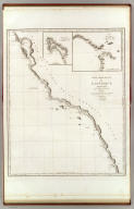
Cote nord-ouest de l'Amerique. Reconnue par le Cape. Vancouver. 1e. partie, depuis 3000' de latitude septle. et 244032' de longitude jusqu'a 38030' de late. et 237013' de longe. (with) Port St. Diego. (with) Entree de Port St. Francisco. Voyage de Vancouver. No. 4. (Paris: Depot-general de la Marine, 1828)
Publisher
Depot de la Marine
Author
Bache, A. D.
Full Title
San Diego Entrance and approaches, California. From a trigonometrical survey under the direction of A.D. Bache, Superintendent of the Survey of the Coast of the United States. R.D. Cutts & Geo. Davidson, assistants and A.M. Harrison, sub assistant. Published in 1853. (with) General sketch of San Diego Bay and Los Coronados. Redd. drng. by F. Herbst. Engg. by S. Siebert, G. McCoy & E. Yeager. Electrotype copy no. 1 by G. Mathiot, U.S.C.S. No. 45. (with logo) U.S. Coast Survey Office.
Publisher
U.S.
1-2 of 2
|