Who What Where WhenREMOVEWHAT
WHERE
|
Author
Wheeler, G.M.
Full Title
Parts Of Eastern California And Western Nevada, Atlas Sheet 47(D). Issued June 30, 1882. Weyss, Lang and Herman, Del. Expeditions of 1876 and 1877 Under the Command of 1st. Lieut. Geo. M. Wheeler, Corps of Engineers, U.S. Army. Executive Officers and Field Astronomers: 1st. Lieut. S.E. Tillman, Corps of Engineers, U.S. Army; 2nd Lieuts. T.W. Symons, Corps of Engineers, U.S. Army and M.M. Macomb, 4th Artillery, U.S. Army. Topographical Assistants: Gilbert Thompson, Anton Karl, Frank Carpenter, W.A. Cowles. U.S. Geographical Surveys West Of The 100th Meridian.
Publisher
U.S.
Full Title
Sketch map showing localities of ancient mounds and burial places on the south California coast & outlying islands. Julius Bien, Photo-lith. U.S. Geographical Surveys West of the 100th Meridian. (1879)
Publisher
U.S.
Author
Cram, George Franklin
Full Title
Map of California. George F. Cram, Engraver & Publisher, Chicago, Ill. (1909)
Publisher
E.A. Davis
Author
Bache, A. D.
Full Title
Reconnaissance of the Western Coast of the United States from San Francisco to San Diego by the hydrographic party under the command of Lieut. James Alden, U.S.N., assistant. U.S. Coast Survey. A.D. Bache, Superintendent. Drawn by W.B. McMurtrie; reduction for engraving by W.M.C. Fairfax. Outlines & topography engraved by G. McCoy; views by G. McCoy & S.V. Hunt; lettering by W. Smith. Electrotype copy no. 6 by G. Mathiot, U.S.C.S. (with logo) U.S. Coast Survey Office.
Publisher
U.S.
Author
Bache, A. D.
Full Title
San Diego Entrance and approaches, California. From a trigonometrical survey under the direction of A.D. Bache, Superintendent of the Survey of the Coast of the United States. R.D. Cutts & Geo. Davidson, assistants and A.M. Harrison, sub assistant. Published in 1853. (with) General sketch of San Diego Bay and Los Coronados. Redd. drng. by F. Herbst. Engg. by S. Siebert, G. McCoy & E. Yeager. Electrotype copy no. 1 by G. Mathiot, U.S.C.S. No. 45. (with logo) U.S. Coast Survey Office.
Publisher
U.S.
Author
Bache, A. D.
Full Title
Reconnaissance of Catalina Harbor and the anchorage on the N.E. side of the island, California. J. No. 4. U.S. Coast Survey, A.D. Bache, Superintendent. By the hydrographic party under the command of Lieut. James Alden, U.S.N., assistant. 1852. (with) View of Catalina Harbor. Topography and view by W.B. McMurtrie. Topography engraved by A. Rolle, view by G. McCoy, lettering by E.F. Woodward. Electrotype copy no. 1 by G. Mathiot, U.S.C.S. (with logo) U.S. Coast Survey Office.
Publisher
U.S.
Author
Bache, A. D.
Full Title
Preliminary sketch of Santa Barbara, California. U.S. Coast Survey. A.D. Bache, Superintendent. Topography by A.M. Harrison sub-assistant. Hydrography by the party under the command of Lieut. James Alden, U.S.N., assistant. 1853. (with) View of the town and mission of Santa Barbara. Reduction for engraving by J. Lambert, draughtsman. Topography engraved by M.F.O. Strobel, view of J. Jung, lettering by W. Smith. Electrotype copy no. 1 by G. Mathiot, U.S.C.S. (with logo) U.S. Coast Survey Office. No. 45.
Publisher
U.S.
Author
Bache, A. D.
Full Title
Reconnaissance of the harbors of Santa Cruz, San Simeon, Coxo and San Luis Obispo, California. U.S. Coast Survey. A.D. Bache, Superintendent. By the hydrographic party under the command of Lieut. James Alden, U.S. Navy, assistant. 1852. Reduction for engraving by Frs. Herbst and E. Hergesheimer. Outlines and topography engraved by H.C. Evens and Max. F.O. Strobel, lettering by H.M. Knight. (with logo) U.S. Coast Survey Depot.
Publisher
U.S.
Author
Bache, A. D.
Full Title
Monterey Harbor, California. From a trigonometrical survey under the direction of A.D. Bache, Superintendent of the Survey of the Coast of the United States. Triangulation by R.D. Cutts, assistant. Topography by R.D. Cutts, asst. and A.M. Harrison, sub-asst. Hydrography by the party under the command of Lieut. James Alden, N.S.N (sic), asst. Published in 1852. (with) View of Pt. Pinos N. 3/4 (by compass) 5 miles. View of W.B. McMurtrie, reduction of topography for engraving by J. Lambert. Topography engraved by S. Siebert, view by S.V. Hunt, lettering by E.F. Woodward. Electrotype copy no. 2 by G. Mathiot, U.S.C.S. (with logo) U.S. Coast Survey Office.
Publisher
U.S.
Author
Bache, A. D.
Full Title
Reconnaissance of San Pedro Harbor, California. U.S. Coast Survey. A.D. Bache, Superintendent. By the hydrographic party under the command of Lieut. Comdg. James Alden, U.S.N., assistant. 1852. (with) View of San Pedro, Pt. Fermin bearing W.N.W. (compass) 4 miles. Reduction for engraving by Frs. Herbst. Outlines & topography engraved by H.C. Evens; view by S.V. Hunt; lettering by S.E. Stull. Electrotype copy no. 1 by G. Mathiot, U.S.C.S. (with logo) U.S. Coast Survey Office.
Publisher
U.S.
Author
Bache, A. D.
Full Title
U.S. Coast Survey A.D. Bache, Superintendent, city of San Francisco and its vicinity, California. From a trigonometrical survey by R.D. Cutts, assistant. Topography by A.F. Rodgers sub-assistant. Hydrography by the party under the command of Lieut. James Alden U.S.N. Asst. 1853. U.S. Coast Survey Office. Verified I.I. Stevens ... Outlines and Topography engraved by Max. F.O. Strobel; Lettering by E.F. Woodward. Electrotype copy no. 1 by G. Mathiot, U.S.C.S.
Publisher
U.S.
Author
Bache, A. D.
Full Title
Mare Island Straits, California. U.S. Coast Survey, A.D. Bache, Superintendent. Triangulation by J.S. Williams and R.D. Cutts, assts., U.S.C.S. and Lt. S.F. Blunt, U.S.N., Joint Commn. Army & Navy officers. Topography by R.D. Cutts, asst., U.S.C.S. Hydrography by the party under the command of W.P. McArthur, Lieut U.S.N. and asst. U.S.C.S. 1851.
Publisher
U.S.
Author
Bache, A. D.
Full Title
Preliminary survey of Humboldt Bay, California. U.S. Coast Survey. A.D. Bache, Superintendent. (with) Sketch of Humboldt Bay. (with) View of Red Bluff, entrance Humboldt Bay ... By the hydrographic party under the command of Lieut. James Alden, U.S.N. and assist. U.S.C.S. 1852. Second edition. Topography engraved by G. McCoy and H.M. Knight, view by G. McCoy, outlines by T. Donohoo, lettering by W. Smith. Topography & view by W.B. McMurtrie, reduction for engraving-outlines by M.I. McClery, topography by Frs. Herbst, hydrography by M.C. Gritzner. (with logo) U.S. Coast Survey Office.
Publisher
U.S.
Author
Bache, A. D.
Full Title
Reconnaissance of Trinidad Bay, California. U.S. Coast Survey, A.D. Bache, Superintendent. By the hydrographic party under the command of Lieut. James Alden, U.S.N. and asst. U.S.C.S. 1851. (with) View of Trinidad Head and city. Topography & view by W.B. McMurtrie.
Publisher
U.S.
Author
Flemming, Carl
Full Title
Californien, Oregon, Utah und Neu-Mejico. Entw. u. gez. v. F. Handtke. Druck u. Verlag v. C. Flemming in Glogau. (1855)
Publisher
C. Flemming
Author
Wheeler, G.M.
Full Title
Parts Of Eastern California And Western Nevada. Atlas Sheet No. 56B. Issued March 31st 1883. Weyss, Rock & Spiller, Del. Expeditions of 1876 & 1877 Under the Command of 1st. Lieut. Geo. M. Wheeler, Corps of Engineers, U.S. Army. Executive Officer & Field Astronomer: 2nd. Lieut. M.M. Macomb, 4th Artillery, U.S. Army. Topographical Assistants: F. Carpenter, W.A. Cowles. U.S. Geographical Surveys West Of The 100th Meridian.
Publisher
U.S.
Author
Cram, George Franklin
Full Title
Cram's Rail Road & Township Map of California. Published by Geo. F. Cram. Proprietor of the Western Map Depot. 66, Lake St. Chicago Ills. 1875.
Publisher
Cram Atlas Company
Author
Mitchell, Samuel Augustus
Full Title
A New Map of the States of California, the Territories of Oregon, Washington, Utah & New Mexico. Published By Charles Desilver, No. 714 Chestnut Street, Philadelphia. Entered according to Act of Congress in the year 1856 by Charles Desilver in the Clerk's office if the District Court of the Eastern District of Pennsylvania. 37.
Publisher
Charles Desilver.
Author
Wheeler, G.M.
Full Title
Parts Of Central California. Atlas Sheet No. 56(D). Weyss, Rock & Spiller, Del. Expeditions of 1878, '79, Under the Command of Capt. Geo. M. Wheeler, Corps of Engineers, U.S. Army. Executive Officer & Field Astronomer: 1st. Lieut. M.M. Macomb, 4th Artillery, U.S. Army. Topographical Assistants: J.C. Spiller, F.O. Maxson. Geographical Surveys West Of The 100th Meridian.
Publisher
U.S.
Author
Rand McNally and Company
Full Title
Rand McNally junior auto road map California, Nevada. Copyright by Rand McNally & Co., Chicago, Ill. (1927)
Publisher
Rand McNally
Author
Rand McNally and Company
Full Title
Denver and vicinity. San Francisco and vicinity. Los Angeles and vicinity. Copyright by Rand McNally & Co., Chicago, Ill. (1927)
Publisher
Rand McNally
Author
Wheeler, G.M.
Full Title
Parts Of Southern Nevada And Eastern California, Atlas Sheet No. 57. The Graphic Co. Photo-Lith. 39 & 41 Park Place N.Y. Weyss, Herman & Lang Del. Expedition Of 1871 Under the Command of 1st. Lieut. Geo. M. Wheeler, Corps of Engineers. Geographical Explorations & Surveys West Of The 100th Meridian.
Publisher
U.S.
Author
Wheeler, G.M.
Full Title
Atlas Sheet Number 58. Parts Of E. California, S.E. Nevada, N.W. Arizona & S.W. Utah. Atlas Sheet Number 66. Weyss, Herman & Aguirre, Del. Expeditions of 1872 & 1873, Under the Command of 1st. Lieut. Geo. M. Wheeler, Corps of Engineers, U.S. Army. Geological Assistants: G.K. Gilbert, A.R. Marvine and E.E. Howell. U.S. Geographical Surveys West Of The One-Hundredth Meridian.
Publisher
U.S.
Author
Wheeler, G.M.
Full Title
Part Of Eastern California, Atlas Sheet No. 65 (D.). Issued May 7th 1877. The Graphic Co. Photo-Lith. 39 & 41 Park Place, N.Y. Weyss, Nell & Lang, Del. Expeditions of 1871 & 75. Under the Command of 1st. Lieut. Geo. M. Wheeler, Corps of Engineers, U.S. Army. Executive Officers and Field Astronomers: 2nd Lt. D.A. Lyle 2nd Art'y U.S. Army and 1st Lt. R. Birnie Jr. 13th Inf'y U.S. Army. Topographical Assistants: 1871, P.W. Hamel and 1871-75, Louis Nell. U.S. Geographical Surveys West Of The 100th Meridian.
Publisher
U.S.
Author
Wheeler, G.M.
Full Title
Land Classification Of Eastern California, Atlas Sheet No. 65 (D.). Issued May 7th 1877. Weyss, Nell & Lang, Del. Expeditions of 1871 & 75. Under the Command of 1st. Lieut. Geo. M. Wheeler, Corps of Engineers, U.S. Army. U.S. Geographical Surveys West Of The 100th Meridian.
Publisher
U.S.
Author
Becker, George F.
Full Title
Geological Map of the Sulphur Bank District. U.S. Geological Survey. Monograph XIII, Atlas Sheet IV. S.H. Bodfish 1882, J.D. Hoffman 1884, Topographers. Giles Litho. & Liberty Printing Co. Geo. F. Becker, Geologist in charge.
Publisher
United States Geological Survey
Author
Becker, George F.
Full Title
Geological Map of the Knoxville District. U.S. Geological Survey. Monograph XIII, Atlas Sheet V. Topography by J.D. Hoffman 1883. Geo. F. Becker, Geologist in charge. Topographical Map of the Region of Clear Lake. Compiled by C.F. Hoffmann. Geo. F. Becker, Geologist in charge.
Publisher
United States Geological Survey
Author
Becker, George F.
Full Title
Geological Map of the New Idria District. U.S. Geological Survey. Monograph XIII, Atlas Sheet VI. J.D. Hoffman, Topographer. Giles Litho. & Liberty Printing Co. N.Y. Geo. F. Becker, Geologist in charge.
Publisher
United States Geological Survey
Author
Becker, George F.
Full Title
Geological Map of the New Almaden Mining District. U.S. Geological Survey. Monograph XIII, Atlas Sheet VII. Topography by S.W. Bodfish and others. Giles Litho. & Liberty Printing Co. N.Y. Geo. F. Becker, Geologist in charge.
Publisher
United States Geological Survey
Author
Becker, George F.
Full Title
Ore-Bodies and Topography of Mine-Hill, New Almaden. U.S. Geological Survey. Monograph XIII, Atlas Sheet VIII. Compiled by F. Reade 1885. Giles Litho. & Liberty Printing Co. N.Y. Geo. F. Becker, Geologist in charge.
Publisher
United States Geological Survey
Author
Becker, George F.
Full Title
Plan of the New Almaden Mine. U.S. Geological Survey. Monograph XIII, Atlas Sheet IX. Compiled by F. Reade 1885. Giles Litho. & Liberty Printing Co. N.Y. Geo. F. Becker, Geologist in charge.
Publisher
United States Geological Survey
Author
Becker, George F.
Full Title
Longitudinal Section of the South Ore Channel. New Almaden Mine. U.S. Geological Survey. Monograph XIII, Atlas Sheet X. Compiled by F. Reade 1885. Giles Litho. & Liberty Printing Co. N.Y. Geo. F. Becker, Geologist in charge.
Publisher
United States Geological Survey
Author
Becker, George F.
Full Title
North and South Section , 550 Feet West of Randol Shaft, New Almaden Mine. North and South Section through the Randol Shaft, New Almaden Mine. U.S. Geological Survey. Monograph XIII, Atlas Sheet XI. Compiled by F. Reade 1885. Geo. F. Becker, Geologist in charge.
Publisher
United States Geological Survey
Author
Becker, George F.
Full Title
East and West Vertical Section, New Almaden Mine. U.S. Geological Survey. Monograph XIII, Atlas Sheet XII. Compiled by F. Reade 1885. Geo. F. Becker, Geologist in charge.
Publisher
United States Geological Survey
Author
Becker, George F.
Full Title
Plan of the Clay Walls, New Almaden Mine. U.S. Geological Survey. Monograph XIII, Atlas Sheet XIII. Compiled by F. Reade 1885. Giles Litho. & Liberty Printing Co. N.Y. Geo. F. Becker, Geologist in charge.
Publisher
United States Geological Survey
Author
Berghaus, Hermann
Full Title
Tieflander. Entw. v. Herm. Berghaus 1883, Ausg. 1887. Gez. v. C. Schmidt u. M. Risch. Gotha: Justus Perthes (1892)
Publisher
Justus Perthes
Author
Berghaus, Hermann
Full Title
Nord-Amerika. Ubersicht von Nord-Amerika. (with) Virginia-Silber-Minen. (with) Das Yosemite-Thal. (with) Landenge von Tehuantepec n. J.C. Spear 1871. (with) Landenge von Nicaragua. (with) Die Krater des Turrialba. (with) Landenge von Panama. (with) Seeboden der New-York-Bay. (with) Popocatepetl. (with) Citlaltepetl. (with) Canons des Colorado. (with) Yellowstone-National-Park. (with) Reykjanes und Geyser nach Th. Thoroddsen. Entw. v. Herm. Berghaus 1886, Ausg. 1887. Nebenkarten gez. v. M. Risch. Gotha: Justus Perthes (1892)
Publisher
Justus Perthes
Author
[Henderson, C.F., Brand, T.S.]
Full Title
H.M.S. "Swiftsure" San Francisco to Magdalena Bay, Dec 1885 (should be 1884).
Publisher
N.P: Manuscript
Author
[Gray, Ormando Willis, Lloyd, H.H., Walling, H. F.]
Full Title
Atlas of the United States. California and Nevada. (Published by Stedman, Brown & Lyon, Cincinnati. 1872. Entered ... 1872, by H.F. Walling, and O.W. Gray, and H.H. Lloyd & Co. ... Washington)
Publisher
Stedman, Brown & Lyon
Author
Mitchell, Samuel Augustus
Full Title
Oregon and Upper California. Published by S. Augustus Mitchell, N.E. corner of Market & Seventh Streets. Philadelphia. 1847. Entered according to Act of Congress in the year 1845 by H.N. Burroughs in the ... District Court of the eastern district of Pennsylvania.
Publisher
S.A. Mitchell
Author
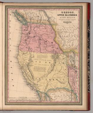
Mitchell, Samuel Augustus
Full Title
Oregon, Upper California & New Mexico. Published by S. Augustus Mitchell, N.E. corner of Market & 7th Sts. Philadelphia. 1849. Entered according to Act of Congress in the year 1845 by H.N. Burroughs in the ... District Court of the eastern district of Penna.
Publisher
S.A. Mitchell
Full Title
A new map of the state of California, the territories of Oregon & Utah, and the chief part of New Mexico. Entered according to Act of Congress in the year 1850 by Thomas, Cowperthwait & Co. in the ... District Court of the eastern district of Pennsylvania. (1852)
Publisher
Thomas, Cowperthwait & Co.
Full Title
A new map of the state of California, the territories of Oregon, Washington, Utah and New Mexico. Published by Thomas, Cowperthwait & Co., no. 253 Market Street, Philadelphia. Entered according to Act of Congress in the year 1853 by Thomas, Cowperthwait & Co. in the ... District Court of the eastern district of Pennsylvania. (1854)
Publisher
Cowperthwait, Desilver, Butler
Author
W. & A.K. Johnston Limited
Full Title
California (North), Nevada, Oregon (South). California (South), Nevada (South), Arizona (West).
Publisher
W. & A.K. Johnston Limited
Full Title
A new map of the state of California, the territories of Oregon, Washington, Utah and New Mexico. Published by Charles Desilver, no. 251 Market Street, Philadelphia. Entered according to Act of Congress in the year 1856 by Charles Desilver in the ... District Court of the eastern district of Pennsylvania. (1857)
Publisher
Charles Desilver
Full Title
Map of the state of California, the territories of Oregon & Utah, and the chief part of New Mexico. Entered according to Act of Congress in the year 1851 by Thomas, Cowperthwait & Co. in the ... District Court of the eastern district of Pennsylvania.
Publisher
Thomas, Cowperthwait & Co.
Author
Tanner, Henry S.
Full Title
A Map of North America, Constructed According To The Latest Information: by H.S. Tanner. S.W. Sheet.. Engraved & Published by H.S. Tanner. Philadelphia. 1822. American Atlas.
Publisher
Henry Tanner
Author
Mitchell, Samuel Augustus
Full Title
Oregon, Upper California & New Mexico. Published By S. Augustus Mitchell. N.E. corner of Market & 7th. Sts. Philadelphia. 1849. Entered ... 1845 by H.N. Burroughs ... Penna.
Publisher
S.A. Mitchell
Author
Mitchell, Samuel Augustus Jr.
Full Title
County map of California. (with two insets) 46. Map of the Settlements in the Great Salt Lake, Utah. 47. San Francisco and Vicinity. Entered ... 1860 by S. Augustus Mitchell, Jr. ... Pennsylvania.
Publisher
S.A. Mitchell Jr.
Author
Thompson, Thos. H.
Full Title
Map of the state of California, compiled expressly for Thos. H. Thompson, publisher, Tulare, Cal. Issued with the Fresno County atlas. Lith. Britton & Rey, S.F. (1891)
Publisher
Thompson Thos. H.
|