Who What Where WhenWHERE
WHO
WHEN
|
Full Title
Plat no. 57 (San Francisco. (Compiled and published by Wm. P. Humphreys & Co., A.B. Holcombe, W.C. Kewen. Eng. by Worley & Bracher ... Phila, Pa. Printed by F. Bourquin ... Phila, Pa. 1876.)
Publisher
W. Humphreys
Full Title
Plat no. 58 (San Francisco. (Compiled and published by Wm. P. Humphreys & Co., A.B. Holcombe, W.C. Kewen. Eng. by Worley & Bracher ... Phila, Pa. Printed by F. Bourquin ... Phila, Pa. 1876.)
Publisher
W. Humphreys
Full Title
Plat no. 59 (San Francisco. (Compiled and published by Wm. P. Humphreys & Co., A.B. Holcombe, W.C. Kewen. Eng. by Worley & Bracher ... Phila, Pa. Printed by F. Bourquin ... Phila, Pa. 1876.)
Publisher
W. Humphreys
Full Title
Plat no. 60 (San Francisco. (Compiled and published by Wm. P. Humphreys & Co., A.B. Holcombe, W.C. Kewen. Eng. by Worley & Bracher ... Phila, Pa. Printed by F. Bourquin ... Phila, Pa. 1876.)
Publisher
W. Humphreys
Full Title
Plat no. 61 (San Francisco. (Compiled and published by Wm. P. Humphreys & Co., A.B. Holcombe, W.C. Kewen. Eng. by Worley & Bracher ... Phila, Pa. Printed by F. Bourquin ... Phila, Pa. 1876.)
Publisher
W. Humphreys
Full Title
Plat no. 62 (San Francisco. (Compiled and published by Wm. P. Humphreys & Co., A.B. Holcombe, W.C. Kewen. Eng. by Worley & Bracher ... Phila, Pa. Printed by F. Bourquin ... Phila, Pa. 1876.)
Publisher
W. Humphreys
Full Title
Plat no. 63 (San Francisco. (Compiled and published by Wm. P. Humphreys & Co., A.B. Holcombe, W.C. Kewen. Eng. by Worley & Bracher ... Phila, Pa. Printed by F. Bourquin ... Phila, Pa. 1876.)
Publisher
W. Humphreys
Author
[Rand McNally and Company, State Farm Insurance Companies Travel Bureau]
Full Title
Rand McNally Road map, California. Copyright by Rand McNally & Company, Chicago, Ill. Lithographed in the U.S.A. (to accompany) State Farm Road Atlas: United States, Canada, Mexico,Central and South America. Copyright 1940 by Rand McNally & Company, Chicago, Ill.
Publisher
State Farm Insurance Companies Travel Bureau
Author
Stieler, Adolf
Full Title
Die Vereinigten Staaten Von Nord-Amerika In 6 Blattern Im Maassstabe Von 1:3.700.000. Von A. Petermann. Bl. 4. Bearbeitet v. H. Habenicht. Gest v. Eberhardt, Kuhn, Metzeroth & Weiler. Gotha: Justus Perthes. 1873.
Publisher
Justus Perthes
Author
[Geographisches Institut (Weimar, Germany), Kiepert, Heinrich, 1818-1899]
Full Title
Mexico, Texas und Californien. (with) Die Republiken von Central-America im Maasstab der Hauptkarte. (with) Haupt-Gold-District in Californien im doppelten maastab der Hauptkarte... (with) Plateau von Mexico ... Bearbeitet und gezeichnet von H. Kiepert. Situation und Schrift gestochen von K. Madel, Terrain von C. Jungmann. Weimar, Verlag des Geographischen Instituts, 1855.
Publisher
Weimar Geo Inst.
Author
Mitchell, Samuel Augustus
Full Title
Oregon and Upper California. Published by S. Augustus Mitchell, N.E. corner of Market & Seventh Streets. Philadelphia. 1848. Entered according to Act of Congress in the year 1845 by H.N. Burroughs in the ... District Court of the eastern district of Pennsylvania.
Publisher
S.A. Mitchell
Full Title
Map of the state of California, the territories of Oregon & Utah, and the chief part of New Mexico. Entered according to Act of Congress in the year 1845 by H.N. Burroughs in the ... District Court of the eastern district of Pennsylvania. (1850)
Publisher
Thomas, Cowperthwait & Co.
Full Title
A new map of the state of California, the territories of Oregon, Washington, Utah and New Mexico. Published by Charles Desilver, no. 251 Market Street, Philadelphia. Entered according to Act of Congress in the year 1856 by Charles Desilver in the ... District Court of the eastern district of Pennsylvania. (1858)
Publisher
Charles Desilver
Full Title
A new map of the state of California, the territories of Oregon, Washington, Utah and New Mexico. Published by Charles Desilver, no. 251 Market Street, Philadelphia. Entered according to Act of Congress in the year 1856 by Charles Desilver in the ... District Court of the eastern district of Pennsylvania. (1858)
Publisher
Cushings & Bailey
Author
[Thomas Bros., Thomas Brothers]
Full Title
(County and Road) Map of California.
Publisher
Thomas Bros.
Author
Thompson, Thos. H.
Full Title
Map of the state of California, compiled expressly for Thos. H. Thompson, publisher, Tulare, Cal. Issued with the Tulare County atlas. Lith. Britton & Rey, S.F. (1892)
Publisher
T.H. Thompson
Author
Thompson, Thos. H.
Full Title
Map of Tulare County, California. 1892. Thos. H. Thompson, Tulare, Cal.
Publisher
T.H. Thompson
Full Title
Township 15 South, Range 25 East, Tulare Co., California. (Compiled, drawn and published by Thos. H. Thompson, Tulare, Cal., 1892)
Publisher
T.H. Thompson
Full Title
Township 15 South, Range 26 East, Tulare Co., California. (Compiled, drawn and published by Thos. H. Thompson, Tulare, Cal., 1892)
Publisher
T.H. Thompson
Full Title
Township 15 South, Range 27 East, Tulare Co., California. (Compiled, drawn and published by Thos. H. Thompson, Tulare, Cal., 1892)
Publisher
T.H. Thompson
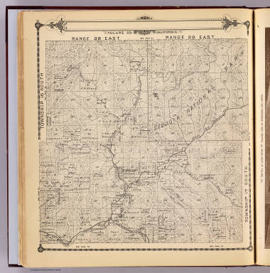
Full Title
Township 15 South, Township 14 South, Range 28 East, Range 29 East, Tulare Co., California. (Compiled, drawn and published by Thos. H. Thompson, Tulare, Cal., 1892)
Publisher
T.H. Thompson
Full Title
Township 15 South, Township 14 South, Range 30 East, Range 31 East, Tulare Co., California. (Compiled, drawn and published by Thos. H. Thompson, Tulare, Cal., 1892)
Publisher
T.H. Thompson
Full Title
Township 17 South ... Township 14 South, Range 32 East ... Range 35 East, Tulare Co., California. (with) Map of Lucerne Colony, Tulare County ... (Compiled, drawn and published by Thos. H. Thompson, Tulare, Cal., 1892)
Publisher
T.H. Thompson
Full Title
Township 16 South, Range 22 East, Tulare Co., California. (with) Map of Mt. Whitney Colony ... (with) Map of Level Orchard Land Colony ... (with) Map of Mack's Addition to Orosi Colony ... (Compiled, drawn and published by Thos. H. Thompson, Tulare, Cal., 1892)
Publisher
T.H. Thompson
Full Title
Township 16 South, Range 23 East, Tulare Co., California. (Compiled, drawn and published by Thos. H. Thompson, Tulare, Cal., 1892)
Publisher
T.H. Thompson
Full Title
Township 16 South, Range 24 East, Tulare Co., California. (Compiled, drawn and published by Thos. H. Thompson, Tulare, Cal., 1892)
Publisher
T.H. Thompson
Full Title
Map of the town of Monson, Tulare County. (with) Map of Lindsay, Tulare County. (with) Map of Zumwalt's subdivision ... (with) Map of Galicia Vineyard ... (Compiled, drawn and published by Thos. H. Thompson, Tulare, Cal., 1892)
Publisher
T.H. Thompson
Full Title
Township 16 South, Range 25 East, Tulare Co., California. (Compiled, drawn and published by Thos. H. Thompson, Tulare, Cal., 1892)
Publisher
T.H. Thompson
Full Title
Township 16 South, Range 26 East, Tulare Co., California. (Compiled, drawn and published by Thos. H. Thompson, Tulare, Cal., 1892)
Publisher
T.H. Thompson
Full Title
Township 16 South, Range 27 East, Tulare Co., California. (Compiled, drawn and published by Thos. H. Thompson, Tulare, Cal., 1892)
Publisher
T.H. Thompson
Full Title
Township 16 South, Township 17 South, Range 28 East, Range 29 East, Tulare Co., California. (Compiled, drawn and published by Thos. H. Thompson, Tulare, Cal., 1892)
Publisher
T.H. Thompson
Full Title
Township 16 South, Township 17 South, Range 30 East, Range 31 East, Tulare Co., California. (Compiled, drawn and published by Thos. H. Thompson, Tulare, Cal., 1892)
Publisher
T.H. Thompson
Full Title
Township 17 South, Range 21 East, Tulare Co., California. (with) Map of Vina Colony ... (with) Map of Oakview Colony ... (with) Map of Holliday Addition ... (with) Map of Sciarone Subdivision ... (all) Tulare County. (Compiled, drawn and published by Thos. H. Thompson, Tulare, Cal., 1892)
Publisher
T.H. Thompson
Full Title
Township 17 South, Range 22 East, Tulare Co., California. (Compiled, drawn and published by Thos. H. Thompson, Tulare, Cal. 1892)
Publisher
T.H. Thompson
Full Title
Township 17 South, Range 23 East, Tulare Co., California. (Compiled, drawn and published by Thos. H. Thompson, Tulare, Cal. 1892)
Publisher
T.H. Thompson
Full Title
Map of Traver, Tulare County. (with) Map of Coe Colony, Tulare Co. (with) Map of Kitchener Colony, Tulare County. (with) Map of Traver Colony, Tulare County. (1892)
Publisher
T.H. Thompson
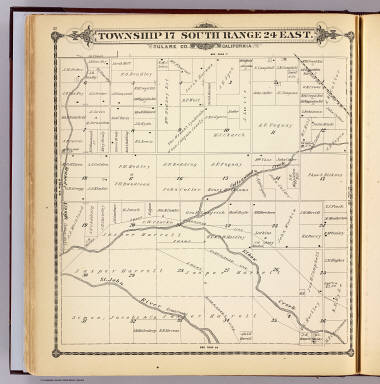
Full Title
Township 17 South, Range 24 East, Tulare Co., California. (Compiled, drawn and published by Thos. H. Thompson, Tulare, Cal. 1892)
Publisher
T.H. Thompson
Full Title
Township 17 South, Range 25 East, Tulare Co., California. (Compiled, drawn and published by Thos. H. Thompson, Tulare, Cal. 1892)
Publisher
T.H. Thompson
Full Title
Township 17 South, Range 26 East, Tulare Co., California. (Compiled, drawn and published by Thos. H. Thompson, Tulare, Cal. 1892)
Publisher
T.H. Thompson
Full Title
Township 17 South, Range 27 East, Tulare Co., California. (Compiled, drawn and published by Thos. H. Thompson, Tulare, Cal. 1892)
Publisher
T.H. Thompson
Author
Bradstreet Company
Full Title
California. (to accompany) Bradstreet's Pocket Atlas Of The United States. Published Exclusively for Macullar, Parker & Company, Boston, Massachusetts ... New York: The Bradstreet Company, 1885. (on verso) Entered ... 1879, by The Bradstreet Company ... Washington.
Publisher
Bradstreet Co.
Author
[U.S. Geological Survey, Alpha, Tau Rho]
Full Title
Eastern Murray Fracture Zone and Transverse Ranges.
Publisher
U.S. Geological Survey
Author
[U.S. Geological Survey, Alpha, Tau Rho, Gerin, Marybeth]
Full Title
Oblique Map of the Northern California Continental Margin.
Publisher
U.S. Geological Survey
Author
[U.S. Geological Survey, Alpha, Tau Rho]
Full Title
Southern California Borderland.
Publisher
U.S. Geological Survey
Author
[U.S. Geological Survey, Alpha, Tau Rho]
Full Title
Oblique Map of Southern California, Santa Barbara to San Deigo.
Publisher
U.S. Geological Survey
Author
[U.S. Geological Survey, Alpha, Tau Rho]
Full Title
Southern California Borderland Oblique Map of the Northwestern Part.
Publisher
U.S. Geological Survey
Author
[U.S. Geological Survey, Alpha, Tau Rho]
Full Title
Ventura-Oxnard Offshore.
Publisher
U.S. Geological Survey
Author
[United Air Lines, White, Ruth Taylor]
Full Title
San Francisco - Reno (upper map). Los Angeles - Boulder Dam (lower map).
Publisher
United Air Lines
Author
Cram, George Franklin
Full Title
California.
Publisher
A.C. Shewey and Co.
Author
[Arrowsmith, Aaron, Humboldt, Alexander von, 1769-1859]
Full Title
(A new map of Mexico and adjacent provinces compiled from original documents by A. Arrowsmith, 1810. Sheet 3). London, Published 5th October 1810 by A. Arrowsmith, 10 Soho Square. (Engraved by E. Jones)
Publisher
A. Arrowsmith
|