Browse All

1865 British Islands. World Atlas British Islands. |

1955 Index: The British Isles, Plate 54, V. I … World Atlas (Index to) The British Isles. Secant Con … |

1955 The British Isles, Plate 54, V. III World Atlas The British Isles. The Geographical Inst … |

1955 Index: Midlands and Scottish Borders, Pl … World Atlas (Index to) Midlands and Scottish Borders … |

1955 Midlands and Scottish Borders, Plate 57, … World Atlas Midlands and Scottish Borders. The Geogr … |

1873 The British Isles. World Atlas The British Isles. |

1953 Europe Economic. United Kingdom. Ireland … World Atlas Europe Economic. United Kingdom. Ireland … |

1953 British Isles. World Atlas British Isles. (insets) Shetland Is. (in … |

1880 British Isles. World Atlas British Isles. W. Swan Sonnenschein & Al … |

1880 British Isles. World Atlas British Isles. W. Swan Sonnenschein & Al … |

1824 Die Britannischen Inseln. Inselgruppen i … [School Atlas, World Atlas] Die Britannischen Inseln. Berlin 1824 vo … |

1901 Stereographical map, British Isles. World Atlas A stereographical map of the British Isl … |

1901 Hydrographical map, British Isles. World Atlas A hydrographical map of the British Isle … |

1901 Geological map, British Isles. World Atlas Geological map of the British Isles by E … |

1901 Parliamentary map, British Isles. World Atlas A parliamentary map of the British Isles … |

1901 Railway map, British Isles. World Atlas A railway map of the British Isles. Lond … |

1901 Rainfall, temperature, British Isles. World Atlas The monthly rainfall and air temperature … |

1901 England & Wales. World Atlas England and Wales. London atlas series. … |

1922 E. ports Gt. Brit. World Atlas Eastern ports of Great Britain. George P … |

1814 Roman Wall in Britain, Brittania Antiqua … World Atlas Roman Wall in Britain ... Drawn & Engrav … |

1832 Berwick-shire. National Atlas Berwick-shire. (with) Berwick. Published … |

1820 British Empire. Historical Atlas Geographical and Historical Map of the B … |

1872 Railway Map of the British Isles. World Atlas Railway Map of the British Isles exhibit … |

1892 Les Britannique. World Atlas Les Britannique. Grave par L. Smith. Dre … |

1837 Iles Britanniques. World Atlas Iles Britanniques or Royaume Uni de la G … |

1854 Die Britischen Inseln 1066 bis 1485. Historical Atlas Die Britischen Inseln, von Wilhelm den E … |

1854 Die Britischen Inseln seit 1485. Historical Atlas Die Britischen Inseln seit 1485. (with) … |

1906 British Isles. Geological Map of the Bri … World Atlas British Isles. Geological Map of the Bri … |

1824 Iles Britanniques ... 1824. World Atlas Iles Britanniques ... 1824. |

1848 Great Britain and Ireland. World Atlas Great Britain and Ireland. |

1780 Carte des Isles Britanniques World Atlas Carte des Isles Britanniques : contenant … |

1863 Iles Britanniques. World Atlas Iles Britanniques. |

1847 Iles Britanniques. World Atlas Carte des Iles Britanniques ... 1838. |

1828 Great Britain and Ireland. Insulae Brita … School Atlas Great Britain and Ireland. Insulae Brita … |

1815 British Isles. World Atlas British Isles. Drawn & engraved by Hewit … |

1702 Isles Britanniques ou sont le Rme. d'Ang … World Atlas Les Isles Britanniques ou sont le Rme. d … |

1922 Towns of England & Scotland on a uniform … World Atlas Towns of England & Scotland on a uniform … |

1883 British Isles. World Atlas British Isles. Letts's popular atlas. Le … |

1794 Gt. Britain, Ireland. World Atlas Great Britain and Ireland. Drawn from th … |

1804 Remote British Isles. World Atlas Remote British Isles. 1. Shetland Island … |

1852 Die Brittischen Inseln und Die Nord-See. … World Atlas No. XVII. Stieler's Hand-Atlas (No. 15a. … |

1905 Ubersichtskarte von Groszbritannien und … World Atlas Ubersichtskarte von Groszbritannien und … |

1856 Ethnographic, Gt. Brit., Ireland. Physical Atlas Ethnographic map of Great Britain and Ir … |

1855 Britischen Inseln. World Atlas Die Britischen Inseln, oder die Vereinig … |
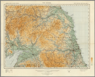
1921 Sheet 1. The Border. National Atlas Sheet 1. The Border. |

1865 Die Britischen Inseln und das Umliegende … World Atlas Stieler's Hand-Atlas ... No. 15a. Die Br … |

1825 England, Schottland und Ireland World Atlas England, Schottland und Ireland; entw. u … |

1823 Die Britischen Inseln World Atlas Die Britischen Jnseln England, Schotland … |

1875 Composite: Grossbritannien. World Atlas (Composite of) Grossbritannien Im Maasss … |

1850 Die Brittischen Inseln und Die Nord-See. … World Atlas No. XVII. Stieler's Hand-Atlas (No. 15a. … |