Who What Where WhenWHEREShow Less |
REFINE
Browse All : Atlas Map of England from 1852
1-10 of 10
Full Title
Die Brittischen Inseln. England, Schottland, Ireland. (Efter Stielers Hand-Atlas. Stockholm, J.L. Brudin, 1852)
Publisher
J.L. Brudin
Author
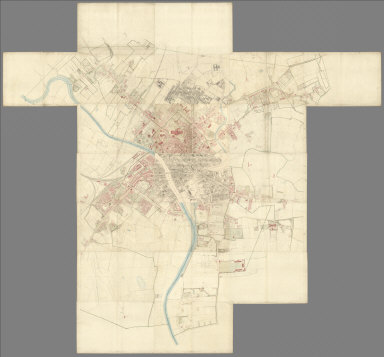
[Great Britain. Ordnance Survey, Tucker, Henry]
Full Title
(Composite to) (Sheets 1 - 21) York. Surveyed in 1850, by Captain Tucker; R.E. Engraved in 1851, under the direction of Captain Yolland, R.E. at the Ordnance Map Office, Southampton, and Published by Lt. Colonel Hall R.E. Superintendent, 1st. Sept., 1852.
Publisher
Ordnance Survey Map Office
Author
Johnston, A. Keith
Full Title
The Mountains, Table Lands, Plains & Valleys of the British Isles.
Publisher
William Blackwood & Sons
Author
[Geological Survey of Great Britain and Ireland, Great Britain, Ordnance Survey Office]
Full Title
72. Burton on Trent, Stafford, SE Quad.
Publisher
Ordnance Map Office
Author
[Geological Survey of Great Britain and Ireland, Great Britain, Ordnance Survey Office]
Full Title
77. Holyhead, N Quad.
Publisher
Ordnance Map Office
Author
[Geological Survey of Great Britain and Ireland, Great Britain, Ordnance Survey Office]
Full Title
78. Bangor, NE Quad.
Publisher
Ordnance Map Office
Author
[Geological Survey of Great Britain and Ireland, Great Britain, Ordnance Survey Office]
Full Title
78. N. Anglesey, Bangor, NW Quad.
Publisher
Ordnance Map Office
Author
[Geological Survey of Great Britain and Ireland, Great Britain, Ordnance Survey Office]
Full Title
78. Bangor, SE Quad.
Publisher
Ordnance Map Office
Author
[Stieler, Adolf, Stulpnagel, F.v.]
Full Title
No. XVII. Stieler's Hand-Atlas (No. 15a.) Die Brittischen Inseln und Die Nord-See.
Publisher
Justus Perthes
1-10 of 10
|