Who What Where WhenWHERE
|
Author
Stieler, Adolf
Full Title
Grossbritannien Im Maassstabe Von 1:1.500.000. Sudliches Blatt: England (Ohne Die Nordl. Grafschaften) U. Wales. Von A. Petermann. Bearb. v. Ernst Debes. Gest. v. Poppey u. Jungmann. Gotha: Justus Perthes. 1872.
Publisher
Justus Perthes
Author
Stieler, Adolf
Full Title
(Composite of) Grossbritannien Im Maassstabe von 1:1.500.000. Von A. Petermann. Gestochen von Poppey u. Jungmann. Gotha: Justus Perthes. 1872.
Publisher
Justus Perthes
Author
Carey, Mathew
Full Title
An Accurate Map of England and Wales With The Principal Roads from the best Authorities. Doolittle Sc. Newhaven. Engraved for Carey's American Edition of Guthrie's Geography improved.
Publisher
M. Carey
Author
[Stieler, Adolf, Stulpnagel, F.v.]
Full Title
No. XVII. Stieler's Hand-Atlas (No. 15a.) Die Brittischen Inseln und Die Nord-See.
Publisher
Justus Perthes
Author
[Stieler, Adolf, Stulpnagel, F.v.]
Full Title
No. XVIII. Stieler's Hand-Atlas (No. 15b.) England und Wales.
Publisher
Justus Perthes
Author
[Carey, Henry Charles, Lea, Isaac]
Full Title
England & Wales. (to accompany) The Juvenile Atlas or a Series Of Maps, To Illustrate the Old and New Worlds ...1822.
Publisher
H.C. Carey & I. Lea
Author
Bartholomew, J. G.
Full Title
British Isles, Comparative Value of Land, Comparative Density of Population
Publisher
George Newnes, Limited
Author
Bartholomew, J. G.
Full Title
British Isles - Industrial. Agricultural. Iron Industries. Textiles. Glass, Earthenware. &c. (Statistical Diagram) Occupations in the British Isles, 1901.
Publisher
George Newnes, Limited
Author
Johnston, A. Keith
Full Title
The Mountains, Table Lands, Plains & Valleys of the British Isles.
Publisher
William Blackwood & Sons
Author
Smith, Charles
Full Title
England and Wales.
Publisher
C. Smith
Author
Kirkwood, Robert
Full Title
United Kingdoms of Great Britain and Ireland.
Publisher
[Robert Kirkwood, John Smith & Son]
Author
Kirkwood, Robert
Full Title
England and Wales.
Publisher
[Robert Kirkwood, John Smith & Son]
Author
Wilkinson, Robert
Full Title
Britain, or the United Kingdom of England, Scotland, & Ireland.
Publisher
Robert Wilkinson
Author
Wilkinson, Robert
Full Title
England and Wales.
Publisher
Robert Wilkinson
Author
Wilkinson, Robert
Full Title
A New Map of Great Britain and Ireland.
Publisher
R. Wilkerson
Author
Wilkinson, Robert
Full Title
England and Wales.
Publisher
R. Wilkerson
Author
Wilkinson, Robert
Full Title
The Dioceses of England with their Alterations to the Present Time.
Publisher
Robert Wilkinson
Author
Wilkinson, Robert
Full Title
Britannia Romana.
Publisher
Robert Wilkinson
Author
Bourne, E.
Full Title
Saxon England.
Publisher
Robert Wilkinson
Author
Stieler, Adolf
Full Title
No. XVII. Stielers Hand-Atlas (No. 15). Die Brittischen Inseln, England, Schotland, Ireland.
Publisher
Justus Perthus
Author
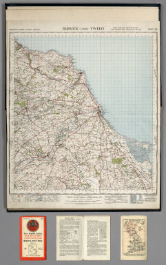
Great Britain. Ordnance Survey
Full Title
Sheet 64. Berwick-upon-Tweed.
Publisher
Ordnance Survey of Great Britain
Author
Great Britain. Ordnance Survey
Full Title
Sheet 71. Alnwick.
Publisher
Ordnance Survey of Great Britain
Author
Great Britain. Ordnance Survey
Full Title
Sheet 75. Dumfries.
Publisher
Ordnance Survey of Great Britain
Author
Great Britain. Ordnance Survey
Full Title
Sheet 76. Carlisle.
Publisher
Ordnance Survey of Great Britain
Author
Great Britain. Ordnance Survey
Full Title
Sheet 77. Hexham.
Publisher
Ordnance Survey of Great Britain
Author
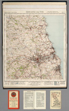
Great Britain. Ordnance Survey
Full Title
Sheet 78. Newcastle upon Tyne.
Publisher
Ordnance Survey of Great Britain
Author
Great Britain. Ordnance Survey
Full Title
Sheet 82. Keswick.
Publisher
Ordnance Survey of Great Britain
Author
Great Britain. Ordnance Survey
Full Title
Sheet 83. Penrith.
Publisher
Ordnance Survey of Great Britain
Author
Great Britain. Ordnance Survey
Full Title
Sheet 84. Teesdale.
Publisher
Ordnance Survey of Great Britain
Author
Great Britain. Ordnance Survey
Full Title
Sheet 85. Durham.
Publisher
Ordnance Survey of Great Britain
Author
Great Britain. Ordnance Survey
Full Title
Sheet 86. Redcar and Whitby.
Publisher
Ordnance Survey of Great Britain
Author
Great Britain. Ordnance Survey
Full Title
Sheet 87. Isle of Man. (also known as Sheet 17).
Publisher
Ordnance Survey of Great Britain
Author
Great Britain. Ordnance Survey
Full Title
Sheet 88. Barrow in Furness.
Publisher
Ordnance Survey of Great Britain
Author
Great Britain. Ordnance Survey
Full Title
Sheet 89. Lancaster and Kendal.
Publisher
Ordnance Survey of Great Britain
Author
Great Britain. Ordnance Survey
Full Title
Sheet 90. Askrigg and Settle.
Publisher
Ordnance Survey of Great Britain
Author
Great Britain. Ordnance Survey
Full Title
Sheet 91. Ripon.
Publisher
Ordnance Survey of Great Britain
Author
Great Britain. Ordnance Survey
Full Title
Sheet 92. Pickering.
Publisher
Ordnance Survey of Great Britain
Author
Great Britain. Ordnance Survey
Full Title
Sheet 93. Scarborough.
Publisher
Ordnance Survey of Great Britain
Author
Great Britain. Ordnance Survey
Full Title
Sheet 94. Preston.
Publisher
Ordnance Survey of Great Britain
Author
Great Britain. Ordnance Survey
Full Title
Sheet 95. Blackburn and Burnley.
Publisher
Ordnance Survey of Great Britain
Author
Great Britain. Ordnance Survey
Full Title
Sheet 96. Leeds and Bradford.
Publisher
Ordnance Survey of Great Britain
Author
Great Britain. Ordnance Survey
Full Title
Sheet 97. York.
Publisher
Ordnance Survey of Great Britain
Author
Great Britain. Ordnance Survey
Full Title
Sheet 98. Market Weighton.
Publisher
Ordnance Survey of Great Britain
Author
Great Britain. Ordnance Survey
Full Title
Sheet 99. Hull.
Publisher
Ordnance Survey of Great Britain
Author
Great Britain. Ordnance Survey
Full Title
Sheet 100. Liverpool.
Publisher
Ordnance Survey of Great Britain
Author
Great Britain. Ordnance Survey
Full Title
Sheet 101. Manchester.
Publisher
Ordnance Survey of Great Britain
Author
Great Britain. Ordnance Survey
Full Title
Sheet 102. Huddersfield.
Publisher
Ordnance Survey of Great Britain
Author
Great Britain. Ordnance Survey
Full Title
Sheet 103. Doncaster.
Publisher
Ordnance Survey of Great Britain
Author
Great Britain. Ordnance Survey
Full Title
Sheet 104. Gainsborough.
Publisher
Ordnance Survey of Great Britain
|