Who What Where WhenWHERE
|
Author
Barcelona, Carlos de
Full Title
Fr. Carlos de Barcelona - [1779?]. S Doc 91 55 2. 74. Sketch Map of the Capuchin Missions in Guayana about 1779. Map III. Sketch Map of the Missions of the Catalonia Capuchins in the Spanish Province of Guayana, [1779?]. Reproduced from a Photolithographic Facsimile of the Manuscript Original in the Archives of the Capuchin Order at Rome given by Father Joseph Strickland, S.J., in his Documents and Maps on the Boundary Question between Venezuela and British Guayana, Rome, 1898. Photo. Lith. by A. Hoen & Co., Baltimore, MD.
Publisher
United States of America
Author
Strickland, Joseph
Full Title
Anonymous - [1789?]. S Doc 91 55 2. 75. Sketch Map of the Capuchin Missions in the Province of Guayana about 1789. Map IV. Sketch Map of the Missions of the Catalonia Capuchins in the Spanish Province of Guayana, about 1789. Reproduced from a Photolithographic Facsimile of the Original Manuscript in the Archives of the Capuchin Order at Rome given by Father Joseph Strickland, S.J., in his Documents and Maps on the Boundary Question between Venezuela and British Guayana, Rome, 1898. Photo. Lith. by A. Hoen & Co., Baltimore, MD.
Publisher
United States of America
Author
Anonymous
Full Title
Anonymous [15--]. S Doc 91 55 2. 76. Mapa de los Rios Amazonas, Esequiyo o Dulche y Orinoca y de las Comarcas Adyacentes. Reproducido por la lit. del Instituto Geografico y Estadistico Ano de 1877. Early Spanish Map of Guiana, Reproduced from Lithographic Facsimile of the Manuscript Original in the Spanish Archives, Published by the Spanish Government in Cartes de Indias (Madrid, 187).
Publisher
United States of America
Author
Colton, G.W.
Full Title
Colton's Brazil and Guayana. (inset) Pernambuco and Rio de Janeiro. Published By G. W & C. B. Colton & Co. No. 172 William St. New York.
Publisher
G. W & C. B. Colton & Co.
Author
[Brue, Adrien Hubert, 1786-1832, Levasseur, E.]
Full Title
Carte des republiques de l'Equateur, de Colombie, de Venezuela, et Guyanes Francaise, Hollandaise, et Anglaise. Dresse par A. Brue, Geographe. Reoue par E. Levasseur, Membre de l'Institut, Institut Geographique de Paris. Ch. Delagrave. Editeur de la Societe de Geographie. 58 Rue des Ecoles. Atlas Universel en 67 feuilles No. 65.
Publisher
Institut Geographique de Paris
Author
Hammond, C.S.
Full Title
Venezuela. 19.
Publisher
Garden City Publishing Company, Inc.
Author
[Schrader, Vivien St Martin, L.]
Full Title
Brasil N.E. et Guyanes. Carte 74. Dresse par Victor Huot. 12-30. Imp. Dufrenoy. Librarie Hachette. Grave par E. Delaune, la lettre par Er. Dumas-Vorxet.
Publisher
Librairie Hachette
Author
[Martin, R.M., Tallis, J. & F.]
Full Title
British Guayana. The Illustrations Drawn & Engraved by H. Winkles. The Map Drawn & Engraved by J. Rapkin.
Publisher
J. & F. Tallis
Author
Popple, Henry
Full Title
A Map of the British Empire in America with the French and Spanish Settlements adjacent thereto. by Henry Popple. (Sheet 19).
Publisher
Willm. Henry Toms & R.W. Seale.
Author
Popple, Henry
Full Title
A Map of the British Empire in America with the French and Spanish Settlements adjacent thereto. by Henry Popple. (Sheet 19).
Publisher
Willm. Henry Toms & R.W. Seale
Author
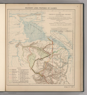
Venezuela-British Guiana Boundary Commission
Full Title
Boundary Lines Proposed or Claimed. 1. S Doc 91 55 2. The Orinoco - Essequibo Region, South America Compiled under the Direction of the Commission Appointed "To Investigate and Report upon the True Divisional Line between the Republic of Venezuela and British Guiana." 1897. Lith. by A. Hoen & Co., Baltimore, MD.
Publisher
United States of America
Author
Venezuela-British Guiana Boundary Commission
Full Title
Forests and Savannas. 2. S Doc 91 55 2. The Orinoco - Essequibo Region, South America, Compiled under the Direction of the Commission Appointed "To Investigate and Report upon the True Divisional Line between the Republic of Venezuela and British Guiana." Washington D.C. 1897. Lith. by A. Hoen & Co., Baltimore, MD.
Publisher
United States of America
Author
Carey, Mathew
Full Title
A New Map of the Caracas. Warnicke Sc.
Publisher
M. Carey and Son
Author
Pinkerton, John, 1758-1826
Full Title
The Caracas. Drawn under the direction of Mr. Pinkerton by L. Hebert. Neele sculpt. 352 Strand. London: published 19th. October 1810 by Cadell & Davies, Strand & Longman, Hurst, Rees, Orme, & Brown, Paternoster Row.
Publisher
[Cadell and Davies, Longman, Hurst, Rees, Orme, and Brown]
|