Who What Where WhenWHO
WHEN
|
Author
Hayes, Eli L.
Full Title
Upper Ohio River and Valley part V, 64 to 81 miles below Pittsburgh, 386 to 403 miles above Cincinnati. (with) La Grange ... (with) Mingo ... (with) Warrenton & Portland Station ... (all) Jefferson Co., Ohio. (with) Wellsburg, Brooke Co. W. Va. (... compiled & drawn for the publishers by E.L. Hayes, assisted by E.F. Hayes, C.M. Beresford, assisted by S.A. Charpiot, F.L. Sanford, J.H. Sherman. Published by Titus, Simmons & Titus ... Phila. 1877. Eng. by Worley & Bracher ... Printed by H.J. Toudy & Co. ... Oldach & Mergenthaler Binders ...)
Publisher
Titus, Simmons & Titus
Author
Hayes, Eli L.
Full Title
Outline plan of Steubenville, Jefferson Co., Ohio. (... compiled & drawn for the publishers by E.L. Hayes, assisted by E.F. Hayes, C.M. Beresford, assisted by S.A. Charpiot, F.L. Sanford, J.H. Sherman. Published by Titus, Simmons & Titus ... Phila. 1877. Eng. by Worley & Bracher ... Printed by H.J. Toudy & Co. ... Oldach & Mergenthaler Binders ...)
Publisher
Titus, Simmons & Titus
Author
Hayes, Eli L.
Full Title
Steubenville, Jefferson Co., Ohio, 1st, 4th. & parts of 2nd., 3rd., & 5th. wards. (... compiled & drawn for the publishers by E.L. Hayes, assisted by E.F. Hayes, C.M. Beresford, assisted by S.A. Charpiot, F.L. Sanford, J.H. Sherman. Published by Titus, Simmons & Titus ... Phila. 1877. Eng. by Worley & Bracher ... Printed by H.J. Toudy & Co. ... Oldach & Mergenthaler Binders ...)
Publisher
Titus, Simmons & Titus
Author
Hayes, Eli L.
Full Title
Upper Ohio River and Valley part VI, 81 to 97 miles below Pittsburgh, 370 to 386 miles above Cincinnati. (with) Tiltonville, Jeff. Co. O. (with) West Wheeling, Belmont Co., O. (with) Benwood, Marshall Co., W. Va. (... compiled & drawn for the publishers by E.L. Hayes, assisted by E.F. Hayes, C.M. Beresford, assisted by S.A. Charpiot, F.L. Sanford, J.H. Sherman. Published by Titus, Simmons & Titus ... Phila. 1877. Eng. by Worley & Bracher ... Printed by H.J. Toudy & Co. ... Oldach & Mergenthaler Binders ...)
Publisher
Titus, Simmons & Titus
Author
Hayes, Eli L.
Full Title
Martin's Ferry, Belmont Co., Ohio. (... compiled & drawn for the publishers by E.L. Hayes, assisted by E.F. Hayes, C.M. Beresford, assisted by S.A. Charpiot, F.L. Sanford, J.H. Sherman. Published by Titus, Simmons & Titus ... Phila. 1877. Eng. by Worley & Bracher ... Printed by H.J. Toudy & Co. ... Oldach & Mergenthaler Binders ...)
Publisher
Titus, Simmons & Titus
Full Title
The state of Tennessee. (Philadelphia: Published by Robert Desilver, 1822)
Publisher
Robert DeSilver
Full Title
The state of Ohio with part of Upper Canada, &c. (Philadelphia: Published by Robert Desilver, 1822)
Publisher
Robert DeSilver
Author
Hayes, Eli L.
Full Title
City of Bellaire, Belmont Co., Ohio. (... compiled & drawn for the publishers by E.L. Hayes, assisted by E.F. Hayes, C.M. Beresford, assisted by S.A. Charpiot, F.L. Sanford, J.H. Sherman. Published by Titus, Simmons & Titus ... Phila. 1877. Eng. by Worley & Bracher ... Printed by H.J. Toudy & Co. ... Oldach & Mergenthaler Binders ...)
Publisher
Titus, Simmons & Titus
Author
Hayes, Eli L.
Full Title
Bridgeport, Belmont Co., O. (with) Industry and Powhattan, Belmont Co., Ohio. (... compiled & drawn for the publishers by E.L. Hayes, assisted by E.F. Hayes, C.M. Beresford, assisted by S.A. Charpiot, F.L. Sanford, J.H. Sherman. Published by Titus, Simmons & Titus ... Phila. 1877. Eng. by Worley & Bracher ... Printed by H.J. Toudy & Co. ... Oldach & Mergenthaler Binders ...)
Publisher
Titus, Simmons & Titus
Author
Hayes, Eli L.
Full Title
Moundsville, Marshall Co., W. Va. (with) Belpre, Washington Co., O. (... compiled & drawn for the publishers by E.L. Hayes, assisted by E.F. Hayes, C.M. Beresford, assisted by S.A. Charpiot, F.L. Sanford, J.H. Sherman. Published by Titus, Simmons & Titus ... Phila. 1877. Eng. by Worley & Bracher ... Printed by H.J. Toudy & Co. ... Oldach & Mergenthaler Binders ...)
Publisher
Titus, Simmons & Titus
Author
Hayes, Eli L.
Full Title
Upper Ohio River and Valley part VII, 96 to 116 miles below Pittsburgh, 351 to 371 miles above Cincinnati. (with) Steinersville, Belmont Co., O. (with) Sunfish, Clarington, Monroe Co., O. (... compiled & drawn for the publishers by E.L. Hayes, assisted by E.F. Hayes, C.M. Beresford, assisted by S.A. Charpiot, F.L. Sanford, J.H. Sherman. Published by Titus, Simmons & Titus ... Phila. 1877. Eng. by Worley & Bracher ... Printed by H.J. Toudy & Co. ... Oldach & Mergenthaler Binders ...)
Publisher
Titus, Simmons & Titus
Author
Hayes, Eli L.
Full Title
Upper Ohio River and Valley part VIII, 117 to 135 miles below Pittsburgh, 332 to 350 miles above Cincinnati. (with) Baresville, Monroe County, O., Hannibal P.O. (with) Sardis, Monroe Co., O. (with) New Martinsville, Wetzel Co., W. Va. (... compiled & drawn for the publishers by E.L. Hayes, assisted by E.F. Hayes, C.M. Beresford, assisted by S.A. Charpiot, F.L. Sanford, J.H. Sherman. Published by Titus, Simmons & Titus ... Phila. 1877. Eng. by Worley & Bracher ... Printed by H.J. Toudy & Co. ... Oldach & Mergenthaler Binders ...)
Publisher
Titus, Simmons & Titus
Author
Hayes, Eli L.
Full Title
Upper Ohio River and Valley part IX, 136 to 151 miles below Pittsburgh, 3l6 to 331 miles above Cincinnati. (with) Sistersville, Tyler County, West Virginia. (with) Cochransville, Centerview P.O., Monroe Co., O. (with) Grandview, Washington Co., O. (with) Matamoras, Washington Co., Ohio, New Matamoras P.O. (... compiled & drawn for the publishers by E.L. Hayes, assisted by E.F. Hayes, C.M. Beresford, assisted by S.A. Charpiot, F.L. Sanford, J.H. Sherman. Published by Titus, Simmons & Titus ... Phila. 1877. Eng. by Worley & Bracher ... Printed by H.J. Toudy & Co. ... Oldach & Mergenthaler Binders ...)
Publisher
Titus, Simmons & Titus
Author
Hayes, Eli L.
Full Title
Upper Ohio River and Valley part X, 152 to 172 miles below Pittsburgh, 295 to 315 miles above Cincinnati. (with) St. Mary's, Pleasants Co., W. Va. (with) Newport, Washington Co., O. (with) Williamstown, Wood Co., W. Va. (... compiled & drawn for the publishers by E.L. Hayes, assisted by E.F. Hayes, C.M. Beresford, assisted by S.A. Charpiot, F.L. Sanford, J.H. Sherman. Published by Titus, Simmons & Titus ... Phila. 1877. Eng. by Worley & Bracher ... Printed by H.J. Toudy & Co. ... Oldach & Mergenthaler Binders ...)
Publisher
Titus, Simmons & Titus
Author
Rand McNally and Company
Full Title
Rand McNally junior auto road map Ohio. Copyright by Rand McNally & Company, Chicago, Ill. (1927)
Publisher
Rand McNally
Author
Rand McNally and Company
Full Title
Atlanta and vicinity. Jacksonville and vicinity. Memphis and vicinity. Cleveland and vicinity. Copyright by Rand McNally & Co., Chicago, Ill. (1927)
Publisher
Rand McNally
Author
Rand McNally and Company
Full Title
Cincinnati and vicinity. Detroit and vicinity. Indianapolis and vicinity. Minneapolis St. Paul and vicinity. Copyright by Rand McNally & Co., Chicago, Ill. (1927)
Publisher
Rand McNally
Author
Hayes, Eli L.
Full Title
Upper Ohio River and Valley part XXII, 382 to 400 miles below Pittsburgh, 67 to 85 miles above Cincinnati. (with) Manchester, Adams Co., O. (with) Wrightsville, Adams Co., O. (... compiled & drawn for the publishers by E.L. Hayes, assisted by E.F. Hayes, C.M. Beresford, assisted by S.A. Charpiot, F.L. Sanford, J.H. Sherman. Published by Titus, Simmons & Titus ... Phila. 1877. Eng. by Worley & Bracher ... Printed by H.J. Toudy & Co. ... Oldach & Mergenthaler Binders ...)
Publisher
Titus, Simmons & Titus
Author
Hayes, Eli L.
Full Title
Upper Ohio River and Valley part XXIII, 401 to 418 miles below Pittsburgh, 49 to 66 miles above Cincinnati. (with) Aberdeen ... (with) Levanna ... (both) Brown Co., O. (... compiled & drawn for the publishers by E.L. Hayes, assisted by E.F. Hayes, C.M. Beresford, assisted by S.A. Charpiot, F.L. Sanford, J.H. Sherman. Published by Titus, Simmons & Titus ... Phila. 1877. Eng. by Worley & Bracher ... Printed by H.J. Toudy & Co. ... Oldach & Mergenthaler Binders ...)
Publisher
Titus, Simmons & Titus
Author
Hayes, Eli L.
Full Title
Ripley, Brown Co., Ohio. (... compiled & drawn for the publishers by E.L. Hayes, assisted by E.F. Hayes, C.M. Beresford, assisted by S.A. Charpiot, F.L. Sanford, J.H. Sherman. Published by Titus, Simmons & Titus ... Phila. 1877. Eng. by Worley & Bracher ... Printed by H.J. Toudy & Co. ... Oldach & Mergenthaler Binders ...)
Publisher
Titus, Simmons & Titus
Author
Hayes, Eli L.
Full Title
Upper Ohio River and Valley part XXIV, 418 to 434 miles below Pittsburgh, 33 to 49 miles above Cincinnati. (with) Chilo ... (with) Rural ... (with) Utopia ... (all) Clermont Co., O. (... compiled & drawn for the publishers by E.L. Hayes, assisted by E.F. Hayes, C.M. Beresford, assisted by S.A. Charpiot, F.L. Sanford, J.H. Sherman. Published by Titus, Simmons & Titus ... Phila. 1877. Eng. by Worley & Bracher ... Printed by H.J. Toudy & Co. ... Oldach & Mergenthaler Binders ...)
Publisher
Titus, Simmons & Titus
Author
Hayes, Eli L.
Full Title
Higginsport, Brown Co., Ohio. (with) Neville ... (with) Point Pleasant ... (both) Clermont Co., Ohio. (... compiled & drawn for the publishers by E.L. Hayes, assisted by E.F. Hayes, C.M. Beresford, assisted by S.A. Charpiot, F.L. Sanford, J.H. Sherman. Published by Titus, Simmons & Titus ... Phila. 1877. Eng. by Worley & Bracher ... Printed by H.J. Toudy & Co. ... Oldach & Mergenthaler Binders ...)
Publisher
Titus, Simmons & Titus
Author
Lucas, Fielding Jr.
Full Title
Ohio. Drawn & Published by F. Lucas Jr., Baltimore. Engraved by J.V.N. Throop. (1822)
Publisher
Fielding Lucas
Author
Hayes, Eli L.
Full Title
New Richmond, Clermont co., Ohio. (with) Moscow, Clermont Co., O. (... compiled & drawn for the publishers by E.L. Hayes, assisted by E.F. Hayes, C.M. Beresford, assisted by S.A. Charpiot, F.L. Sanford, J.H. Sherman. Published by Titus, Simmons & Titus ... Phila. 1877. Eng. by Worley & Bracher ... Printed by H.J. Toudy & Co. ... Oldach & Mergenthaler Binders ...)
Publisher
Titus, Simmons & Titus
Author
Hayes, Eli L.
Full Title
Upper Ohio River and Valley part XXVI, 452 to 467 miles below Pittsburgh, from Cincinnati to 15 miles above. (... compiled & drawn for the publishers by E.L. Hayes, assisted by E.F. Hayes, C.M. Beresford, assisted by S.A. Charpiot, F.L. Sanford, J.H. Sherman. Published by Titus, Simmons & Titus ... Phila. 1877. Eng. by Worley & Bracher ... Printed by H.J. Toudy & Co. ... Oldach & Mergenthaler Binders ...)
Publisher
Titus, Simmons & Titus
Author
Hayes, Eli L.
Full Title
Cincinnati, Ohio and vicinity. (... compiled & drawn for the publishers by E.L. Hayes, assisted by E.F. Hayes, C.M. Beresford, assisted by S.A. Charpiot, F.L. Sanford, J.H. Sherman. Published by Titus, Simmons & Titus ... Phila. 1877. Eng. by Worley & Bracher ... Printed by H.J. Toudy & Co. ... Oldach & Mergenthaler Binders ...)
Publisher
Titus, Simmons & Titus
Author
Colton, G.W.
Full Title
Ohio. No. 39. Published by J.H. Colton & Co., No 172 William St., New York. Entered according to the Act of Congress in the year 1855 by J.H. Colton & Co. in the Clerk's Office of the District Court of the United States for the Southern District of New York.
Publisher
J.H. Colton
Author
Colton, G.W.
Full Title
The Cities of Pittsburgh and Allegheny with Parts of Adjacent Boroughs, Pennsylvannia. The City of Cincinnati, Ohio. No. 40. Published by J.H. Colton & Co., No 172 William St., New York. Entered according to the Act of Congress in the year 1855 by J.H. Colton & Co. in the Clerk's Office of the District Court of the United States for the Southern District of New York.
Publisher
J.H. Colton
Author
Hayes, Eli L.
Full Title
Index map to Atlas of the Upper Ohio River & Valley. (... compiled & drawn for the publishers by E.L. Hayes, assisted by E.F. Hayes, C.M. Beresford, assisted by S.A. Charpiot, F.L. Sanford, J.H. Sherman. Published by Titus, Simmons & Titus ... Phila. 1877. Eng. by Worley & Bracher ... Printed by H.J. Toudy & Co. ... Oldach & Mergenthaler Binders ...)
Publisher
Titus, Simmons & Titus
Author
Hayes, Eli L.
Full Title
Upper Ohio River and Valley part III, 32 to 46 miles below Pittsburgh, 421 to 435 miles above Cincinnati. (with) Smiths Ferry ... (with) Glasgow ... (with) Industry ... (all) Beaver Co., Pa. (or Penna.) (... compiled & drawn for the publishers by E.L. Hayes, assisted by E.F. Hayes, C.M. Beresford, assisted by S.A. Charpiot, F.L. Sanford, J.H. Sherman. Published by Titus, Simmons & Titus ... Phila. 1877. Eng. by Worley & Bracher ... Printed by H.J. Toudy & Co. ... Oldach & Mergenthaler Binders ...)
Publisher
Titus, Simmons & Titus
Author
Hayes, Eli L.
Full Title
Wellsville, Columbiana Co., O. (with) Jethro ... (with) East Liverpool ... (both) Columbiana Co., O. (with) Hamilton, Hancock Co., W. Va. (... compiled & drawn for the publishers by E.L. Hayes, assisted by E.F. Hayes, C.M. Beresford, assisted by S.A. Charpiot, F.L. Sanford, J.H. Sherman. Published by Titus, Simmons & Titus ... Phila. 1877. Eng. by Worley & Bracher ... Printed by H.J. Toudy & Co. ... Oldach & Mergenthaler Binders ...)
Publisher
Titus, Simmons & Titus
Author
Burr, David H., 1803-1875
Full Title
Ohio. Entered ... Novr. 11th in the year 1831 by David H. Burr ... New York.
Publisher
D.S. Stone
Author
Caldwell, Joseph A.
Full Title
Map of the Pittsburgh, Cincinnati and St. Louis R.R. Pan Handle Route and Principal Connections. Rand Mcnally & Co., Engraver, Chicago. Printed under Patent of January 12, 1875. ( (to accompany) Caldwell's Illustrated, Historical, Centennial Atlas Of Beaver County, Pennsylvania. From actual Surveys by & under the directions of J.A. Caldwell. Assisted by C.T. Arms, Sr. C.E. J.A. Underwood, C.E. J.A. Howden. P.L. Mason. W.J. Kerstetter, C.E. W.F. Arms, C.E. J.J. Power, C.E. Published By J.A. Caldwell, Condit, Ohio. 1876. Engraved, Lithographed & Printed By Otto Krebs, Pittsburgh, Pa.
Publisher
J.A. Caldwell
Author
Bradford, Thomas G.
Full Title
Washington. Louisville and Jeffersonville. New Orleans. Cincinnati. Entered ... 1838, by T.G. Bradford ... Massachusetts.
Publisher
[Weeks, Jordan & Co., Wiley and Putnam.]
Author
Finley, Anthony
Full Title
Map of the States Of Ohio Indiana & Illinois And Part Of Michigan Territory Compiled from the Latest Authorities. D.H. Vance Del. J.H. Young Sc. Philada. Published by A. Finley 1825.
Publisher
Anthony Finley
Author
Bradford, Thomas G.
Full Title
Ohio. Entered ... 1838, by T.G. Bradford ... Massachusetts.
Publisher
[Weeks, Jordan & Co., Wiley and Putnam.]
Author
[Slater, J., Whittlesey, Chas.]
Full Title
Historical map of the State of Ohio. Showing the location of ancient earth works and the country occupied by the principal Indian tribes between 1750 and 1780 with their principal trails and war-paths by Col. Chas. Whittlesey, President of the Western Reserve and Northern Ohio Historical Society, Cleveland, Ohio, 1872. (with view) Ancient mound 2 miles east of Miamisburg, Montgomery Co., Ohio ... Photographed ... by J. Slater, 1872. (Published by Stedman, Brown & Lyon, Cincinnati. 1872. Entered ... 1872, by H.F. Walling, and O.W. Gray, and H.H. Lloyd & Co. ... Washington)
Publisher
Stedman, Brown & Lyon
Author
Newberry, John S.
Full Title
Geological map of Ohio by J.S. Newberry, Chief Geologist, 1872. (Published by Stedman, Brown & Lyon, Cincinnati. 1872. Entered ... 1872, by H.F. Walling, and O.W. Gray, and H.H. Lloyd & Co. ... Washington)
Publisher
Stedman, Brown & Lyon
Author
Klippart, J. H.
Full Title
Agricultural map of Ohio. Showing the distribution of soils, the localities of the principal productions, and the names and limits of the valleys and other natural divisions. By J.H. Klippart, Secretary of the Ohio State Board of Agriculture. 1872. (Published by Stedman, Brown & Lyon, Cincinnati. 1872. Entered ... 1872, by H.F. Walling, and O.W. Gray, and H.H. Lloyd & Co. ... Washington)
Publisher
Stedman, Brown & Lyon
Author
Blodget, Lorin
Full Title
Climatological map of the State of Ohio. By Lorin Blodget, 1872. (Published by Stedman, Brown & Lyon, Cincinnati. 1872. Entered ... 1872, by H.F. Walling, and O.W. Gray, and H.H. Lloyd & Co. ... Washington)
Publisher
Stedman, Brown & Lyon
Author
Bowen, B. F.
Full Title
City of Columbus, Franklin Co., Ohio. Drawn by B.F. Bowen, City Eng., Columbus, O., 1872. (Published by Stedman, Brown & Lyon, Cincinnati. 1872. Entered ... 1872, by H.F. Walling, and O.W. Gray, and H.H. Lloyd & Co. ... Washington)
Publisher
Stedman, Brown & Lyon
Author
Gray, Frank Arnold
Full Title
New rail road map of the State of Ohio, compiled and drawn by Frank Arnold Gray, 1872. (Published by Stedman, Brown & Lyon, Cincinnati. 1872. Entered ... 1872, by H.F. Walling, and O.W. Gray, and H.H. Lloyd & Co. ... Washington)
Publisher
Stedman, Brown & Lyon
Author
[Gray, Ormando Willis, Lloyd, H.H., Walling, H. F.]
Full Title
Cleveland, Cayahoga Co. From data furnished by City Engineer. 1872. (Published by Stedman, Brown & Lyon, Cincinnati. 1872. Entered ... 1872, by H.F. Walling, and O.W. Gray, and H.H. Lloyd & Co. ... Washington)
Publisher
Stedman, Brown & Lyon
Author
Marston, John B.
Full Title
Toledo, Lucas Co. by J.B. Marston, C.E., Toledo O. (Published by Stedman, Brown & Lyon, Cincinnati. 1872. Entered ... 1872, by H.F. Walling, and O.W. Gray, and H.H. Lloyd & Co. ... Washington)
Publisher
Stedman, Brown & Lyon
Author
[Gray, Ormando Willis, Lloyd, H.H., Walling, H. F.]
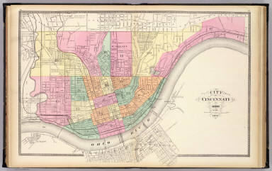
Full Title
City of Cincinnati, Ohio. 1872. (Published by Stedman, Brown & Lyon, Cincinnati. 1872. Entered ... 1872, by H.F. Walling, and O.W. Gray, and H.H. Lloyd & Co. ... Washington)
Publisher
Stedman, Brown & Lyon
Author
[Gray, Ormando Willis, Lloyd, H.H., Walling, H. F.]
Full Title
Dayton. (Published by Stedman, Brown & Lyon, Cincinnati. 1872. Entered ... 1872, by H.F. Walling, and O.W. Gray, and H.H. Lloyd & Co. ... Washington)
Publisher
Stedman, Brown & Lyon
Author
Moler, J. Douglass
Full Title
Springfield, Clarke Co. by J. Douglass Moler, City Engr. (Published by Stedman, Brown & Lyon, Cincinnati. 1872. Entered ... 1872, by H.F. Walling, and O.W. Gray, and H.H. Lloyd & Co. ... Washington)
Publisher
Stedman, Brown & Lyon
Author
[Gray, Ormando Willis, Lloyd, H.H., Walling, H. F.]
Full Title
Topographical atlas of Ohio. Cuyahoga, Erie, Huron, Lorain, Medina, Ottawa, Sandusky, Seneca and Summit counties. (Published by Stedman, Brown & Lyon, Cincinnati. 1872. Entered ... 1872, by H.F. Walling, and O.W. Gray, and H.H. Lloyd & Co. ... Washington)
Publisher
Stedman, Brown & Lyon
Author
[Gray, Ormando Willis, Lloyd, H.H., Walling, H. F.]
Full Title
Topographical atlas of Ohio. Ashtabula, Geauga, Lake, Mahoning, Portage and Trumbull counties. (Published by Stedman, Brown & Lyon, Cincinnati. 1872. Entered ... 1872, by H.F. Walling, and O.W. Gray, and H.H. Lloyd & Co. ... Washington)
Publisher
Stedman, Brown & Lyon
|