|
|
REFINE
Browse All : Atlas Map of Trumbull County (Ohio) from 1899
1-29 of 29
Author
American Atlas Company
Full Title
Map of Hubbard.
Publisher
American Atlas Company
Author
American Atlas Company
Full Title
Map of Brookfield.
Publisher
American Atlas Company
Author
American Atlas Company
Full Title
Map of Hartford.
Publisher
American Atlas Company
Author
American Atlas Company
Full Title
Map of Vernon.
Publisher
American Atlas Company
Author
American Atlas Company
Full Title
Map of Kinsman.
Publisher
American Atlas Company
Author
American Atlas Company
Full Title
Map of Liberty.
Publisher
American Atlas Company
Author
American Atlas Company
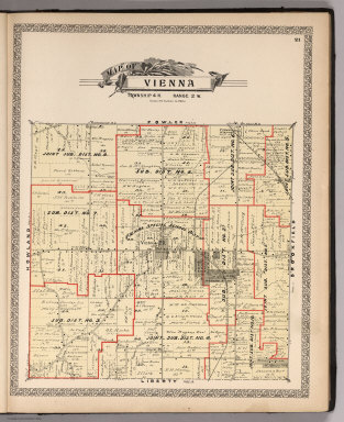
Full Title
Map of Vienna.
Publisher
American Atlas Company
Author
American Atlas Company
Full Title
Map of Fowler.
Publisher
American Atlas Company
Author
American Atlas Company
Full Title
Map of Johnston.
Publisher
American Atlas Company
Author
American Atlas Company
Full Title
Map of Gustavus.
Publisher
American Atlas Company
Author
American Atlas Company
Full Title
Map of Weathersfield.
Publisher
American Atlas Company
Author
American Atlas Company
Full Title
Map of Howland.
Publisher
American Atlas Company
Author
American Atlas Company
Full Title
Map of Bazetta.
Publisher
American Atlas Company
Author
American Atlas Company
Full Title
Map of Mecca.
Publisher
American Atlas Company
Author
American Atlas Company
Full Title
Map of Greene.
Publisher
American Atlas Company
Author
American Atlas Company
Full Title
Map of Lordstown.
Publisher
American Atlas Company
Author
American Atlas Company
Full Title
Map of Warren.
Publisher
American Atlas Company
Author
American Atlas Company
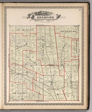
Full Title
Map of Champion.
Publisher
American Atlas Company
Author
American Atlas Company
Full Title
Map of Bristol.
Publisher
American Atlas Company
Author
American Atlas Company
Full Title
Map of Bloomfield.
Publisher
American Atlas Company
Author
American Atlas Company
Full Title
Map of Newton.
Publisher
American Atlas Company
Author
American Atlas Company
Full Title
Map of Bracevlle.
Publisher
American Atlas Company
Author
American Atlas Company
Full Title
Map of Southington.
Publisher
American Atlas Company
Author
American Atlas Company
Full Title
Map of Farmington.
Publisher
American Atlas Company
Author
American Atlas Company
Full Title
Map of Mesopotamia.
Publisher
American Atlas Company
Author
American Atlas Company
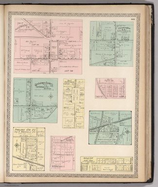
Full Title
Plats East of Vienna Center. Map of Leavittsburg P.O. or West Warren. Map of Johnston Center, Johnstonville P.O.
Publisher
American Atlas Company
Author
American Atlas Company
Full Title
Map of Brookfield Center. (Other areas in Trumbull Conty).
Publisher
American Atlas Company
Author
American Atlas Company
Full Title
Map of North Bloomfield P.O. Farmington P.O. Lordstown Center. Map of Fowler Center. Map of Tyrrell Mill. Phalanx Sta. P.O. Otis Coa Company Plat. Braceville P.O. Walnut Hill ot Bell's Plat.
Publisher
American Atlas Company
Author
American Atlas Company
Full Title
Map of Church Hill P.O. Map of Ohlton, Meander P.O. Mahoning Coal Co's Plat. Map of Coalburg P.O. Moorefield. Hanna Plat. Germantown. Longsville.
Publisher
American Atlas Company
1-29 of 29
|