Who What Where WhenWHOShow More |
REFINE
Browse All : Atlas Map of U.S. North East and United States
1-21 of 21
Author
Society for the Diffusion of Useful Knowledge (Great Britain)
Full Title
North America sheet VII. Pennsylvania, New Jersey, Maryland, Delaware, Columbia and part of Virginia. Published under the superintendence of the Society for the Diffusion of Useful Knowledge. J. & C. Walker sculpt. Published July 15th. 1833 by Baldwin & Cradock, 47 Paternoster Row, London. Printed by J. & C. Walker. (London: Chapman & Hall, 1844)
Publisher
Chapman and Hall
Author
Johnston, Alexander Keith, 1804-1871
Full Title
United States of North America, eastern states, by Keith Johnston, F.R.S.E. Engraved & printed by W. & A.K. Johnston, Edinburgh. William Blackwood & Sons, Edinburgh & London, (1861)
Publisher
William Blackwood & Sons
Author
Woodbridge, William C.
Full Title
Physical And Political Map Of The N. Eastern States. Adapted To Woodbridge's Geography. Drawn & Engd. by Story & Atwood. N. York. Entered .. . 1843, by W.C. Woodbridge ... Massachusetts. Hartford. Published By Wm. Jas. Hamersley.
Publisher
Wm. Jas. Hamersley
Author
Woodbridge, William C.
Full Title
Political Map Of The Northern Division Of the United States. Adapted To Woodbridge's Geography. Entered .. . 1843, by W.C. Woodbridge ... Massachusetts. Hartford. Published By Wm. Jas. Hamersley.
Publisher
Wm. Jas. Hamersley
Author
Woodbridge, William C.
Full Title
Physical & Political Map Of The N. Eastern States. Adapted To Woodbridge's Geography. Drawn and Engrd. by Story & Atwood. N. York. Entered ... 1843, by W.C. Woodbridge ... Massachusetts. Hartford. Published By Wm. Jas. Hamersley. (to accompany) Modern Atlas, Physical, Political And Statistical; Exhibiting On Separate Maps ...
Publisher
Belknap and Hamersley
Author
Woodbridge, William C.
Full Title
Political Map Of the Northern Division Of The United States. Adapted To Woodbridge's Geography. Entered ... 1843, by W.C. Woodbridge ... Massachusetts. Hartford. Published By Wm. Jas. Hamersley. (to accompany) Modern Atlas, Physical, Political And Statistical; Exhibiting On Separate Maps ...
Publisher
Belknap and Hamersley
Full Title
American Atlantic ports--north sheet. George Philip & Son, Ltd. The London Geographical Institute. (1922)
Publisher
[C.S. Hammond & Company. London: George Philip & Son, Ltd. The London Geographical Institute, Philip, Son & Nephew, Ltd.]
Author
Melish, John
Full Title
Northern section of the United States including Canada &c. by John Melish. 1816. Grav. af C.F. Himberg. (Stockholm: Stente af C. Muller, 1824)
Publisher
C. Muller
Author
[Raynal, G.T., Bonne, R.]
Full Title
Carte de la partie nord, Des Etats Unis, de l'Amerique Septentrionale. Par M. Bonne, Ingenieur-Hydrographe de la Marine. (on upper margin) Liv. XVII et XVIII.: No. 47. (on lower margin) 48. (to accompany) Histoire Philosophique et Politique Des Establissements et Du Commerce Des Europeens Dans Les Deux Indes.
Publisher
Jean-Leonard Pellet
Author
Thomson, John
Full Title
Northern provinces of the United States. (with view) The Great Falls of Niagara. Hewitt sc., Grafton Str. E(a)st, Tottenham Ct. Rd. Drawn & engraved for Thomson's New general atlas, 1817.
Publisher
[Baldwin, Cradock, and Joy, John Cumming, John Thomson]
Author
[Bory de Saint-Vincent, M. (Jean Baptiste GeneviFve Marcellin), 1778-1846, Desmarest, Nicolas, 1725-1815, Vincent]
Full Title
Carte des montagnes coupees par des rivieres, situees en Virginie et en Pensylvanie. Grave par Berthe. (A Paris, Chez Mme. veuve Agasse, Imprimeur-Libraire, rue des Poitevins, no. 6. M.DCCCXXVII)
Publisher
Veuve Agasse
Author
Letts, Son & Co.
Full Title
Eastern United States. No. 2. Letts's popular atlas. Letts, Son & Co. Limited, London. (1883)
Publisher
Letts, Son & Co.
Author
Robert Laurie & James Whittle
Full Title
A new and correct map of the British colonies in North America. Comprehending Eastern Canada with the province of Quebec, New Brunswick, Nova Scotia, and the government of Newfoundland; with the adjacent states of New England, Vermont, New York, Pennsylvania and New Jersey. London, Publish'd by Laurie & Whittle, 53 Fleet Street, 12th May, 1794.
Publisher
Laurie & Whittle
Author
Robert Laurie & James Whittle
Full Title
A new and general map of the middle dominions belonging to the United States of America, viz. Virginia, Maryland, the Delaware-Counties, Pennsylvania, New Jersey &c., with the addition of New York, & of the greatest part of New England &c., as also of the bordering parts of the British possessions in Canada. (with) A sketch of the upper parts to shown the remainder of the lakes. London, Published by Laurie & Whittle, No. 53, Fleet Street, as the act directs 12th May, 1794.
Publisher
Laurie & Whittle
Author
Gannett, Henry, 1846-1914
Full Title
Map showing the position of the center of population at the close of each decade from 1790 to 1900 and the location of the median point in 1880, 1890 and 1900. Compiled by Henry Gannett, Geographer. (United States Census Office, 1903). Julius Bien & Co., N.Y.
Publisher
U.S. Census Office
Author
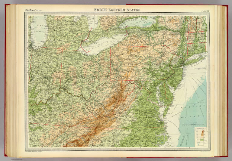
[Bartholomew, J. G. (John George), 1860-1920, John Bartholomew & Co.]
Full Title
North-eastern states. The Edinburgh Geographical Institute, John Bartholomew & Co. "The Times" atlas. (London: The Times, 1922)
Publisher
The Times
Full Title
United States, western. United States, north-eastern. (with Environs of New York City. Published at the office of "The Times," London, 1895)
Publisher
The Times
Full Title
Die Nordost-Staaten der Union. (Richard Andree. Herausgegeben von der Geographischen Anstalt von Velhagen & Klasing in Leipzig. 1881)
Publisher
Velhagen & Klasing
Author
Melish, John
Full Title
D: (Untitled outline map of the United States).
Publisher
(John Melish)
Author
Pinkerton, John, 1758-1826
Full Title
United States of America, northern part. Drawn under the direction of Mr. Pinkerton by L. Hebert. Neele sculpt. 352 Strand. London: published 2d. April 1810 by Cadell & Davies, Strand & Longman, Hurst, Rees, Orme, & Brown, Pater Noster Row.
Publisher
[Cadell and Davies, Longman, Hurst, Rees, Orme, and Brown]
Author
[Robert de Vaugondy, Didier, 1723-1786, Robert de Vaugondy, Gilles, 1688-1766]
Full Title
Partie de l'Amerique Septentrionale, qui comprend le Cours de l'Ohio, la Nlle. Angleterre, la Nlle. York, le New Jersey, la Pensylvanie, le Maryland, la Virginie, la Caroline. Par le Sr. Robert de Vaugondy Geographe ordinaire du Roi. Avec Privilege 1755. M.C. Haussard fecit. (with) Supplement pour la Caroline.
Publisher
[Boudet, Les Auteurs]
1-21 of 21
|