Browse All

1833 Penn., N.J., Md., Dela., D.C., Virginia. World Atlas North America sheet VII. Pennsylvania, N … |

1833 Missouri, Ill., Ky., Tenn., Ala., Miss., … World Atlas North America sheet X. Parts of Missouri … |

1861 United States E. World Atlas United States of North America, eastern … |

1849 Physical & Political Map Of The Southern … School Atlas Physical & Political Map Of The Southern … |

1816 The Southern States and Mississippi Terr … World Atlas The Southern States and Mississippi Terr … |

1845 Political Map Of the Southern Division O … School Atlas Physical & Political Map Of the Southern … |

1883 106. Orchard products, rice. Statistical Atlas Orchard products. Total value, per squar … |

1883 108. Sugar, molasses. Statistical Atlas Sugar and molasses. Sugar ... Molasses. … |

1883 116. Milk, butter. Statistical Atlas Milk. Product per square mile. Sold or s … |

1883 117. Cheese. Statistical Atlas Cheese. Farm product per square mile. Ba … |

1922 American Atlantic ports S. World Atlas American Atlantic ports--south sheet. Ge … |

1816 S. section U.S. National Atlas Southern section of the United States in … |
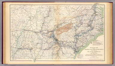
1895 Military map, W.T. Sherman. Military Atlas Military map of the marches of the Unite … |

1895 Gen. map I. Military Atlas General topographical map. Sheet I. Juli … |

1817 S. United States. World Atlas Southern provinces of the United States. … |

1883 E. United States 8. World Atlas Eastern United States. No. 8. Letts's po … |

1903 52. Center Negro population 1880-1900. Statistical Atlas Sketch map showing the position of the c … |

1813 Southern Section of the United States in … National Atlas Southern Section of the United States in … |

1815 Southern Section of the United States in … National Atlas Southern Section of the United States in … |

1809 United States of America, southern part. World Atlas United States of America, southern part. … |

1755 Cours de l'Ohio, Nlle. Angleterre, Nlle. … World Atlas Partie de l'Amerique Septentrionale, qui … |