Who What Where WhenREMOVE |
REFINE
Browse All : Atlas Map of United States and U.S. South
1-21 of 21
Author
Society for the Diffusion of Useful Knowledge (Great Britain)
Full Title
North America sheet VII. Pennsylvania, New Jersey, Maryland, Delaware, Columbia and part of Virginia. Published under the superintendence of the Society for the Diffusion of Useful Knowledge. J. & C. Walker sculpt. Published July 15th. 1833 by Baldwin & Cradock, 47 Paternoster Row, London. Printed by J. & C. Walker. (London: Chapman & Hall, 1844)
Publisher
Chapman and Hall
Author
Society for the Diffusion of Useful Knowledge (Great Britain)
Full Title
North America sheet X. Parts of Missouri, Illinois, Kentucky, Tennessee, Alabama, Mississippi and Arkansas. Published under the superintendence of the Society for the Diffusion of Useful Knowledge. J. & C. Walker sculpt. Published by Baldwin & Cradock, 47 Paternoster Row, 1st. Decr. 1833. (London: Chapman & Hall, 1844)
Publisher
Chapman and Hall
Author
Johnston, Alexander Keith, 1804-1871
Full Title
United States of North America, eastern states, by Keith Johnston, F.R.S.E. Engraved & printed by W. & A.K. Johnston, Edinburgh. William Blackwood & Sons, Edinburgh & London, (1861)
Publisher
William Blackwood & Sons
Author
Woodbridge, William C.
Full Title
Physical & Political Map Of The Southern Division Of the United States. Adapted To Woodbridge's Geography. Entered .. . 1843, by W.C. Woodbridge ... Massachusetts. Hartford. Published By Wm. Jas. Hamersley. (inset map) Vicinity of Charleston. (inset map) Vicinity of New Orleans.
Publisher
Wm. Jas. Hamersley
Author
[Carey, Mathew, Warner, Benjamin]
Full Title
The Southern States and Mississippi Territory. Philadelphia: Published By M. Carey, And B. Warner. 1816.
Publisher
M. Carey and B. Warner
Author
Woodbridge, William C.
Full Title
Physical & Political Map Of the Southern Division Of The United States. Adapted To Woodbridge's Geography. Entered ... 1843, by W.C. Woodbridge ... Massachusetts. Hartford. Published By Wm. Jas. Hamersley. (to accompany) Modern Atlas, Physical, Political And Statistical; Exhibiting On Separate Maps ... (inset map) Vicinity of Charleston. (inset map) vicinity of New Orleans.
Publisher
Belknap and Hamersley
Full Title
Orchard products. Total value, per square mile of total area ... Rice. Product per square mile of total area. Based on the returns of the tenth census. 1880. Copyright, 1883, by Charles Scribner's Sons.
Publisher
Charles Scribner's Sons
Full Title
Sugar and molasses. Sugar ... Molasses. Product, per square mile of total area. Sugar-cane product. Based on the returns of the tenth census. 1880. Copyright, 1883, by Charles Scribner's Sons.
Publisher
Charles Scribner's Sons
Full Title
Milk. Product per square mile. Sold or sent to butter and cheese factories. ... Butter. Farm product per square mile. Based on the returns of the tenth census. 1880. Copyright, 1883, by Charles Scribner's Sons.
Publisher
Charles Scribner's Sons
Full Title
Cheese. Farm product per square mile. Based on the returns of the tenth census. 1880. Copyright, 1883, by Charles Scribner's Sons.
Publisher
Charles Scribner's Sons
Full Title
American Atlantic ports--south sheet. George Philip & Son, Ltd. The London Geographical Institute. (1922)
Publisher
[C.S. Hammond & Company. London: George Philip & Son, Ltd. The London Geographical Institute, Philip, Son & Nephew, Ltd.]
Author
Melish, John
Full Title
Southern section of the United States including Florida &c. by John Melish. 1816. (Stockholm: Stente af C. Muller, 1824)
Publisher
C. Muller
Author
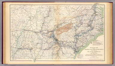
[Jenney, William LeB., United States. War Department]
Full Title
Military map of the marches of the United States forces under command of Maj. Gen. W.T. Sherman, U.S.A. during the years 1863, 1864, 1865. Compiled by order of Maj. Gen. W.T. Sherman ... under the direction of Bvt. Maj. W.L.B. Jenney ... Drawn by Capt. William Kossak ... and John B. Muller, draughtsman. St. Louis, Mo., 1865. Julius Bien & Co., Lith., N.Y. (1891-1895)
Publisher
U.S. Government Printing Office
Author
[Julius Bien & Co., United States. War Department]
Full Title
General topographical map. Sheet I. Julius Bien & Co., Lith., N.Y. (1891-1895)
Publisher
U.S. Government Printing Office
Author
Thomson, John
Full Title
Southern provinces of the United States. (with view) Characteristic scenery of the Hudson River. Hewitt sc., Grafton Str. East, Tottenham Court Rd. Drawn & engraved for Thomson's New general atlas, 1817.
Publisher
[Baldwin, Cradock, and Joy, John Cumming, John Thomson]
Author
Letts, Son & Co.
Full Title
Eastern United States. No. 8. Letts's popular atlas. Letts, Son & Co. Limited, London. (1883)
Publisher
Letts, Son & Co.
Author
Gannett, Henry, 1846-1914
Full Title
Sketch map showing the position of the center of the Negro population and the median point in 1880, 1890 and 1900. Compiled by Henry Gannett, Geographer. (United States Census Office, 1903). Julius Bien & Co., N.Y.
Publisher
U.S. Census Office
Author
Melish, John
Full Title
Southern Section of the United States including Florida &c. by John Melish. Entered ... by John Melish ... 1 March 1813.
Publisher
John Melish
Author
Melish, John
Full Title
Southern Section of the United States including Florida &c. by John Melish. 1816. Entered ... by John Melish ... 1 March 1813. Improved nth. June 1816.
Publisher
John Melish
Author
Pinkerton, John, 1758-1826
Full Title
United States of America, southern part. Drawn under the direction of Mr. Pinkerton by L. Hebert. Neele sculpt. 352 Strand. London: published Octr. 5th. 1809, by Cadell & Davies, Strand & Longman, Hurst, Rees, Orme, & Brown, Paternoster Row.
Publisher
[Cadell and Davies, Longman, Hurst, Rees, Orme, and Brown]
Author
[Robert de Vaugondy, Didier, 1723-1786, Robert de Vaugondy, Gilles, 1688-1766]
Full Title
Partie de l'Amerique Septentrionale, qui comprend le Cours de l'Ohio, la Nlle. Angleterre, la Nlle. York, le New Jersey, la Pensylvanie, le Maryland, la Virginie, la Caroline. Par le Sr. Robert de Vaugondy Geographe ordinaire du Roi. Avec Privilege 1755. M.C. Haussard fecit. (with) Supplement pour la Caroline.
Publisher
[Boudet, Les Auteurs]
1-21 of 21
|