Who What Where WhenREMOVEWHATShow MoreWHO
WHEN
|
Author
Society for the Diffusion of Useful Knowledge (Great Britain)
Full Title
North America sheet IX. Parts of Missouri, Illinois and Indiana. Published under the superintendence of the Society for the Diffusion of Useful Knowledge. Engraved by J. & C. Walker. Published July 1st. 1833 by Baldwin & Cradock, 47 Paternoster Row, London. Printed by Russell, Penge. (London: Chapman & Hall, 1844)
Publisher
Chapman and Hall
Author
Society for the Diffusion of Useful Knowledge (Great Britain)
Full Title
North America sheet X. Parts of Missouri, Illinois, Kentucky, Tennessee, Alabama, Mississippi and Arkansas. Published under the superintendence of the Society for the Diffusion of Useful Knowledge. J. & C. Walker sculpt. Published by Baldwin & Cradock, 47 Paternoster Row, 1st. Decr. 1833. (London: Chapman & Hall, 1844)
Publisher
Chapman and Hall
Author
Society for the Diffusion of Useful Knowledge (Great Britain)
Full Title
Central America II. Texas, California and the northern states of Mexico. Published under the superintendence of the Society for the Diffusion of Useful Knowledge. J. & C. Walker sculpt. Published by Chapman & Hall, 186 Strand, 15th. Oct. 1842. (1844)
Publisher
Chapman and Hall
Author
Colton, G.W.
Full Title
Chart Exhibiting the Relative Rank of the States for Nine Decades (1790-1880). (Published By G. W & C. B. Colton & Co., No. 182 William St. New York).
Publisher
G. W & C. B. Colton & Co.
Author
Colton, G.W.
Full Title
Colton's United States of America. Published by G. W & C. B. Colton & Co., No. 172 William St. New York.
Publisher
G. W & C. B. Colton & Co.
Author
Colton, G.W.
Full Title
Colton's United States of America. Published by G.W. & C.B. Colton & Co., No. 172 William St. New York.
Publisher
G.W. & C.B. Colton
Author
Asher & Adams
Full Title
Asher & Adams' United States and territories. Entered according to Act of Congress in the year 1874 by Asher & Adams ... at Washington. Drawn and engraved by W.H. Holmes. (New York, 1874)
Publisher
Asher and Adams
Author
Cram, George Franklin
Full Title
Map of the United States of America. (inset) Alaska.
Publisher
George F. Cram
Author
Johnston, Alexander Keith, 1804-1871
Full Title
United States of North America, eastern states, by Keith Johnston, F.R.S.E. Engraved & printed by W. & A.K. Johnston, Edinburgh. William Blackwood & Sons, Edinburgh & London, (1861)
Publisher
William Blackwood & Sons
Author
[G.W. & C.B. Colton & Co., Walling, H. F.]
Full Title
Map of the United States of America. Entered according to act of Congress in the year 1873 by G.W. & C.B. Colton & Co ... Washington. (Drawn, compiled, and edited by H.F. Walling, C.E. ... Published by R.M. & S.T. Tackabury, Detroit, Mich. Entered ... 1873, by H.F. Walling ... Washington. The Claremont Manufacturing Company, Claremont, N.H., Book Manufacturers)
Publisher
R.M. & S.T. Tackabury
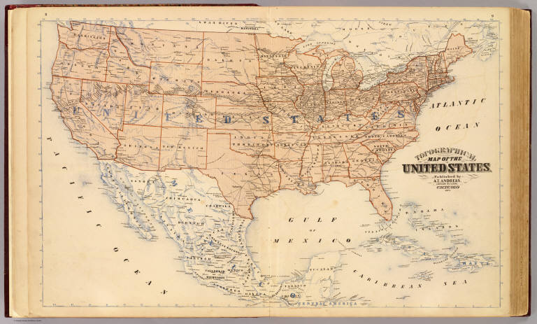
Author
Andreas, A. T. (Alfred Theodore), 1839-1900
Full Title
Topographical map of the United States. Published by A.T. Andreas, Lakeside Building, Chicago, 1873. (Chas. Shober & Co. Proprietors of Chicago Lith. Co.)
Publisher
A.T. Andreas
Author
Andreas, A. T. (Alfred Theodore), 1839-1900
Full Title
Population, United States Census, 1870: Density of population. Foreign population, Colored population, British American population, Swedish and Norwegian population. (Published by A.T. Andreas, Lakeside Building, Chicago, 1874. Chas. Shober & Co. Proprietors of Chicago Lith. Co.)
Publisher
A.T. Andreas
Author
Andreas, A. T. (Alfred Theodore), 1839-1900
Full Title
Agricultural productions colored by grades to show quantity raised in localities, from the ninth census: wheat, hay, corn, cotton, tobacco. (Published by A.T. Andreas, Lakeside Building, Chicago, 1874. Chas. Shober & Co. Proprietors of Chicago Lith. Co.)
Publisher
A.T. Andreas
Author
Andreas, A. T. (Alfred Theodore), 1839-1900
Full Title
Vital statistics, United Census, 1870: Deaths from consumption ... malarial diseases ... enteric cerebro-spinal and typhus fevers ... intestinal diseases. (Published by A.T. Andreas, Lakeside Building, Chicago, 1874. Chas. Shober & Co. Proprietors of Chicago Lith. Co.)
Publisher
A.T. Andreas
Author
Mitchell, Samuel Augustus
Full Title
A New Map of the United States of America. by J.H. Young. Published by Thomas, Cowperthwait & Co. No. 253 Market Street. Philadelphia. Entered ... 1850, by Thomas, Cowperthwait & Co. ... Pennsylvania. (with two inset maps) Gold Regions of California, and District of Columbia.
Publisher
Thomas, Cowperthwait & Co.
Author
Mitchell, Samuel Augustus Jr.
Full Title
Map of the United States, and Territories together with Canada &c. (inset) Island of Newfoundland. Entered ... 1874 by S. Augustus Mitchell ... Washington.
Publisher
Ziegler & McCurdy
Author
Harrison, Richard Edes
Full Title
Outward From The U.S. (to accompany) Look At The World: The Fortune Atlas For world Strategy. By Richard Edes Harrison. Text by Editor of Fortune. New York: Alfred A. Knopf 1944. (on verso) Copyright 1944 by Time Incorporated.
Publisher
A. A. Knopf
Author
Harrison, Richard Edes
Full Title
The U.S. From The Outside. (to accompany) Look At The World: The Fortune Atlas For world Strategy. By Richard Edes Harrison. Text by Editor of Fortune. New York: Alfred A. Knopf 1944. (on verso) Copyright 1944 by Time Incorporated.
Publisher
A. A. Knopf
Author
Woodbridge, William C.
Full Title
United States. Entered ... 1821, by William.C. Woodbridge ... Connecticut. (to accompany) Modern Atlas On A New Plan; To Accompany The System Of Universal Geography, By William Channing Woodbridge ... Exhibiting In Connection With The Outlines Of Countries, The Prevailing Religions, Forms Of Government, And Degrees Of Civilization; The Comparative Size Of Towns, Rivers And Mountains; And The Climates And Productions Of The Earth ... District Of Connecticut, ss. Be It Remembered, That on the twenty-second day of June, in the forty-eighth year of the Independence of the United States of America, William Channing Woodbridge ... and Emma Willard ... have deposited in this Office the title of a book ... Charles A. Ingersoll, Clerk of the District of Connecticut. Hartford: Oliver D. Cooke & Sons, Publishers. (inset) Northern Division Of The United States.
Publisher
Oliver D. Cooke & Sons
Author
Johnson, A.J.
Full Title
Johnson's New Military Map of the United States Showing the Forts, Military Posts &c. With Enlarged Plans of Southern Harbors From Authentic Data Obtained at the War Department, Washington, (by) Johnson and Ward. Entered ... One Thousand Eight Hundred & Sixty-one, by A.J. Johnson & Browning ... New York. With 9 inset maps.
Publisher
Johnson and Ward
Author
Garnier, F. A., 1803-1863
Full Title
Amerique Boreale, Nouvle. Bretagne & Canada. Atlas spheroidal & universel de geographie dresse par F.A. Garnier, geographe. Ve. Jules Renouard, Editeur, Rue de Tournon, no. 6, Paris. 1860. Impie. de Louis Antoine, 1, Rue de Cluny, Paris.
Publisher
Veuve Jules Renouard, Libraire
Author
Garnier, F. A., 1803-1863
Full Title
Etats-Unis de l'Amerique du Nord. Limites en 1855. (with) Iles St. Pierre et Miquelon. (with) Partie sud du Territoire de la Floride. Atlas spheroidal & universel de geographie dresse par F.A. Garnier, geographe. Ve. Jules Renouard, Editeur, Rue de Tournon, no. 6, Paris. 1860. Imp. Sarazin, R. Git-le-Coeur, 8, Paris.
Publisher
Veuve Jules Renouard, Libraire
Author
Garnier, F. A., 1803-1863
Full Title
Etats-Unis de l'Amerique du Nord. Limites en 1860. (with) Iles St. Pierre et Miquelon. Atlas spheroidal & universel de geographie dresse par F.A. Garnier, geographe. Ve. Jules Renouard, Editeur, Rue de Tournon, no. 6, Paris. 1860. Imp. Louis Antoine, r. de Cluny, 1, Paris.
Publisher
Veuve Jules Renouard, Libraire
Author
[Colton, J. H., Marzolla, Benedetto]
Full Title
Stati-Uniti dell'America Settentrionale coi territorii recentemente annessi. La presente Carta e stata costrutta su quella, pubblicata in 4 fogli in Nuova-York nel 1852 da J.H. Colton ... Essa fa parte dell'Atlante Geografico che si pubblica da B. Marzolla. Napoli 1854.
Publisher
B. Marzolla
Author
Arrowsmith, Aaron
Full Title
United States. Drawn by A. Arrowsmith. Engraved by Thomson & Hall. Published, 1817, by A. Constable & Co. Edinburgh.
Publisher
[A. Constable & Co., Longman & Compy]
Author
Bartholomew, John
Full Title
(Index to) United States and the Caribbean. Chamberlin Trimetric Projection, (By courtesy of the National Geographic Society, Washington, D.C.), Standard Parallels 33 (degrees) and 45 (degrees) N. 1:12,500,000.
Publisher
[Houghton Mifflin Co., John Bartholomew & Son LTD.]
Author
Bartholomew, John
Full Title
United States and The Caribbean. The Geographical Institute Edinburgh. Edited by John Bartholomew, M.C. LL. D. Copyright - John Bartholomew & Son, LTD.
Publisher
[Houghton Mifflin Co., John Bartholomew & Son LTD.]
Author
Bartholomew, John
Full Title
(Index to) U.S.A. Middle Atlantic Seaboard. Secant Conic Projection, Standard Parallels 41 (degrees) and 43 (degrees) N. 1:1,000,000.
Publisher
[Houghton Mifflin Co., John Bartholomew & Son LTD.]
Author
Bartholomew, John
Full Title
U.S.A. Middle Atlantic Seaboard. The Geographical Institute Edinburgh. Edited by John Bartholomew, M.C. LL. D. Copyright - John Bartholomew & Son, LTD. (inset map) New York and Environs.
Publisher
[Houghton Mifflin Co., John Bartholomew & Son LTD.]
Author
[Thomson, John, Wyld, James, 1790-1836]
Full Title
North America. Drawn by Wyld. Engraved by Hewitt. Published by John Thomson & Co. Edinburgh. (to accompany) A General Atlas, Containing Maps illustrating some important periods in Ancient History; and distinct Maps of the several Empires, Kingdoms and States In The World, From Original Drawings according to the latest Treaties by J. Wyld and Engraved by N.R. Hewitt. Edinburgh, Printed for John Thomson & Co for Baldwin, Cradock & Joy, London & John Cumming, Dublin.
Publisher
John Thomson
Author
[Thomson, John, Wyld, James, 1790-1836]
Full Title
United States. Drawn by Wyld. Engraved by Hewitt. Published by John Thomson & Co. Edinburgh. (to accompany) A General Atlas, Containing Maps illustrating some important periods in Ancient History; and distinct Maps of the several Empires, Kingdoms and States In The World, From Original Drawings according to the latest Treaties by J. Wyld and Engraved by N.R. Hewitt. Edinburgh, Printed for John Thomson & Co for Baldwin, Cradock & Joy, London & John Cumming, Dublin.
Publisher
John Thomson
Author
[Bayer, Herbert, Container Corporation of America]
Full Title
U.S.A. Political.
Publisher
Container Corporation of America
Author
[Bayer, Herbert, Container Corporation of America]
Full Title
U.S.A. Physiographic.
Publisher
Container Corporation of America
Author
[Bayer, Herbert, Container Corporation of America]
Full Title
U.S.A. Climatic. U.S.A. Population.
Publisher
Container Corporation of America
Author
[Bayer, Herbert, Container Corporation of America]
Full Title
U.S.A. Economic.
Publisher
Container Corporation of America
Author
[Bayer, Herbert, Container Corporation of America]
Full Title
Central U.S.A.
Publisher
Container Corporation of America
Author
[Bayer, Herbert, Container Corporation of America]
Full Title
Western U.S.A.
Publisher
Container Corporation of America
Author
[Bayer, Herbert, Container Corporation of America]
Full Title
U.S.A. Indian Tribes. Types of Farming. Canada.
Publisher
Container Corporation of America
Author
Hall, S. (Sidney)
Full Title
United States. By Sidney Hall. London, published by Longman, Rees, Orme, Brown & Green, Paternoster Row, June, 1828.
Publisher
Longman, Rees, Orme, Brown and Green
Author
Willard, Emma
Full Title
Introductory Map. To Accompany Willard's History Of The United States. Locations and Wanderings Of The Aboriginal Tribes. (Arrow) Shows The Direction Of their Wanderings. Engraved & Printed by Saml. Maverick.
Publisher
White, Gallaher, & White
Author
Willard, Emma
Full Title
First Map Or Map Of 1578. To Accompany Willard's History Of The United States. (Inset) Queen Elizabeth Signs for Sir Humphrey Gilbert. The First patent Granted by an English Sovereign to Lands Within the Territory of the United States 1578. Engraved & Printed by Saml. Maverick.
Publisher
White, Gallaher, & White
Author
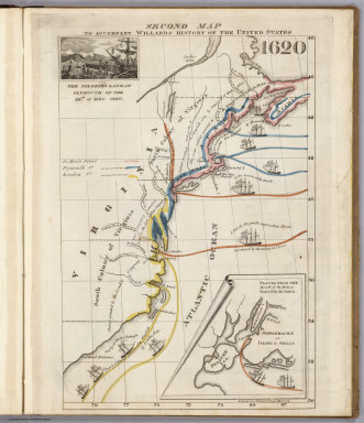
Willard, Emma
Full Title
Second Map. To Accompany Willard's History Of The United States 1620. (Inset) The Pilgrims Land at Plymouth on the 22nd. of Dec. 1620. (inset map) Places Near The Mouth of the Hudson Visited by the Dutch. Engraved & Printed by Saml. Maverick.
Publisher
White, Gallaher, & White
Author
Willard, Emma
Full Title
Third Map or Map Of 1643. To Accompany Willard's History Of The United States. (Inset) The Commencement of the Confederacy in the Union of Plymouth and Massachusetts and New Haven and Connecticut 1643. (inset map) Places Mentioned in the History of the Pequod War. Engraved & Printed by Saml. Maverick N.Y.
Publisher
White, Gallaher, & White
Author
Willard, Emma
Full Title
Fourth Map or Map Of 1692. To Accompany Willard's History Of The United States. (Inset) Massachusetts Receives a New Charter, Including Maine and Other Large Territories by the Arrival of Sir Wm. Phipps. (inset map) Places Mentioned in the History of King Philip's War. (Engraved & Printed by) Saml. Maverick & Co. N.Y.
Publisher
White, Gallaher, & White
Author
Willard, Emma
Full Title
Fifth Map or Map Of 1733. To Accompany Willard's History Of The United States. (Inset) Genl. Oglethorpe with a Colony Commence the Settlement of Georgia 1733. He meets the Indian Chief's in Council at Savannah. (Engraved & Printed by) Saml. Maverick & Co. N.Y.
Publisher
White, Gallaher, & White
Author
Willard, Emma
Full Title
Sixth Map or Map Of 1763. To Accompany Willard's History Of The United States. (Inset) The Death of Gen. Wolf Occurs at the Time of Quebec's Being Taken by the English ... that leads to the Peace of Paris 1763. (inset map) Quebec. Engraved & Printed by Saml. Maverick.
Publisher
White, Gallaher, & White
Author
Willard, Emma
Full Title
Seventh Map or Map Of 1776. To Accompany Willard's History Of The United States. (Inset) A Committee of Five draw up the Declaration of Independence. 1776. (inset map) Boston and Vicinity. (inset) (untitle map showing Lake George and surroundings). (inset) Charleston and Vicinity. Engraved & Printed by Saml. Maverick &Co. N.Y.
Publisher
White, Gallaher, & White
Author
Willard, Emma
Full Title
Eighth Map or Map Of 1789. To Accompany Willard's History Of The United States. (Inset) Federal Government Commen CD 1789. (2 untitled inset maps). (Engraved & Printed by) Saml. Maverick & Co. N.Y.
Publisher
White, Gallaher, & White
Author
Willard, Emma
Full Title
Principal Seat of the Revolutionary War in the Southern Section of the U.S. To Accompany Willard's History Of The United States. (inset map) Principal Seat of the Revolutionary War in the northern section of the U.S. Engraved & Printed by Saml. Maverick.
Publisher
White, Gallaher, & White
Author
Willard, Emma
Full Title
Ninth Map Or Map Of 1826. To Accompany Willard's History Of The United States. Referred to in the History, As the Map of the President Day. 1826. Saml. Maverick & Co. N.Y.
Publisher
White, Gallaher, & White
|