Who What Where When |
REFINE
Browse All : Atlas Map of World from 1811
1-7 of 7
Author
Carey, Mathew
Full Title
A Map of the Discoveries made by Capts. Cook & Clarke in the Years 1778 & 1779 between the Eastern Coast of Asia and the Western Coast of North America, when they attempted to Navigate the North Sea. Also Mr Hearn's discoveries to the North westward of Hudson's Bay, in 1772. J.T. Scott Sculp. Engraved for Carey's Edition of Guthrie's Geography improved.
Publisher
M. Carey
Author
[Faden, William, 1750?-1836, Roberts, Henry, Lieut.]
Full Title
A general chart exhibiting the discoveries made by Captn. James Cook in this and his two preceeding voyages; with the tracks of the ships under his command, by Lieutt. Roberts of His Majesty's Royal Navy. (London, published by W. Faden, 1811)
Publisher
William Faden
Author
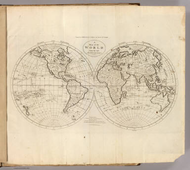
Carey, Mathew
Full Title
A Map of the World from the best Authorities. Thackara & Vallance Sc. Engraved for Carey's Edition of Guthrie's new System of Geography.
Publisher
M. Carey
Author
Carey, Mathew
Full Title
A Chart of the World, According to Mercators Projection, Shewing the latest Discoveries of Capt. Cook. William Barker sculp. Engraved for Carey's American Edition of Guthrie's Geography improved.
Publisher
M. Carey
Author
[Oddy, S.A., Wallis, James]
Full Title
The World with the Latest Discoveries. Drawn and Engraved by James Wallis. London, Published by S.A. Oddy, No. 20 Warwick Lane, 1811.
Publisher
S.A. Oddy
Author
Humboldt, Alexander von, 1769-1859
Full Title
Carte des diverses Routes par lesquelles les richesses metalliques refluent d'un Continent a l'autre. 19. Dessine par J.B. Poirson d'apres une exquisee de Mr. de Humboldt. Grave par L. Aubert.
Publisher
F. Schoell
1-7 of 7
|