Browse All

1878 North, south Dennisville. State Atlas North, south Dennisville. H.C. Woolman, … |

1878 Cape May Court House. State Atlas Cape May Court House. Surv. by H.C. Wool … |

1878 Cape May City and Sea Grove. State Atlas Cape May City. Surv. by R.B. Swain, Cape … |

1838 Indiana. National Atlas Indiana. Entered ... 1838, by T.G. Bradf … |

1872 Historical map of the State of Ohio. State Atlas Historical map of the State of Ohio. Sho … |

1872 Geological map of Ohio. State Atlas Geological map of Ohio by J.S. Newberry, … |

1872 Agricultural map of Ohio. State Atlas Agricultural map of Ohio. Showing the di … |

1872 Climatological map of the State of Ohio. State Atlas Climatological map of the State of Ohio. … |

1838 Illinois. National Atlas Illinois. Entered ... 1838, by T.G. Brad … |

1872 City of Columbus, Franklin Co., Ohio. State Atlas City of Columbus, Franklin Co., Ohio. Dr … |

1872 New rail road map of the State of Ohio. State Atlas New rail road map of the State of Ohio, … |

1872 Cleveland, Cayahoga Co. State Atlas Cleveland, Cayahoga Co. From data furnis … |

1872 Toledo, Lucas Co. State Atlas Toledo, Lucas Co. by J.B. Marston, C.E., … |
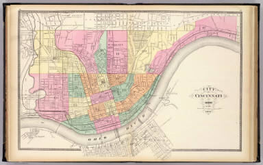
1872 City of Cincinnati, Ohio. State Atlas City of Cincinnati, Ohio. 1872. (Publish … |

1872 Dayton. State Atlas Dayton. (Published by Stedman, Brown & L … |

1872 Springfield, Clarke Co. State Atlas Springfield, Clarke Co. by J. Douglass M … |

1872 Cuyahoga, Erie, Huron, Lorain, Medina, O … State Atlas Topographical atlas of Ohio. Cuyahoga, E … |

1872 Ashtabula, Geauga, Lake, Mahoning, Porta … State Atlas Topographical atlas of Ohio. Ashtabula, … |

1872 Carroll, Columbiana, Harrison, Jefferson … State Atlas Topographical atlas of Ohio. Carroll, Co … |

1838 Michigan. National Atlas Michigan. (inset) Northwest Part of Mich … |

1872 Athens, Belmont, Fairfield, Guernsey, Ho … State Atlas Topographical atlas of Ohio. Athens, Bel … |

1872 Gallia, Jackson, Lawrence, Meigs, and Vi … State Atlas Topographical atlas of Ohio. Gallia, Jac … |

1872 Adams, Brown, Highland, Pike, and Scioto … State Atlas Topographical atlas of Ohio. Adams, Brow … |

1872 Auglaize, Champaign, Clarke, Darke, Dela … State Atlas Topographical atlas of Ohio. Auglaize, C … |

1872 Clinton, Fayette, Greene, Pickaway, and … State Atlas Topographical atlas of Ohio. Clinton, Fa … |

1872 Butler, Clermont, Hamilton, Montgomery, … State Atlas Topographical atlas of Ohio. Butler, Cle … |

1872 Allen, Crawford, Defiance, Fulton, Hanco … State Atlas Topographical atlas of Ohio. Allen, Craw … |

1872 Ashland, Coshocton, Holmes, Knox, Richla … State Atlas Topographical atlas of Ohio. Ashland, Co … |

1872 The world. State Atlas The world. (Published by Stedman, Brown … |

1872 Map of the United States and Territories … State Atlas Map of the United States and territories … |

1838 Delaware. National Atlas Delaware. Entered ... 1838, by T.G. Brad … |

1872 North western America showing the territ … State Atlas North western America showing the territ … |

1887 Richfield, Morton Co., Kansas. State Atlas Richfield, Morton Co., Kansas. L.H. Ever … |

1887 Hodgeman & Ford counties, Bellefont, Wil … State Atlas Hodgeman and Ford counties, Kansas. (wit … |

1887 Johnson City & Ulysses, Kansas, State Atlas Johnson City, Stanton Co., Kansas. (with … |

1887 Dodge City, Ford Co., Kas. State Atlas Dodge City, Ford Co., Kas. L.H. Everts & … |

1887 Ryansville, Ford City, Spearville. State Atlas Ryansville, Ford Co. Ford City, Ford Co. … |

1887 Thomas Co., Kansas. State Atlas Thomas Co., Kansas. L.H. Everts & Co., p … |

1887 Tribune, Greeley Co. (with) Colby, Thoma … State Atlas Tribune, Greeley Co. (with) Colby, Thoma … |

1887 Greeley, Wichita, Scott counties, Leoti, … State Atlas Greeley Co., Wichita Co., Scott Co. (wit … |

1887 Hector, Windhorst, Rio. State Atlas Hector, Greeley Co. (with) Windhorst, Fo … |

1887 Jetmore, Scott City, Hanston, Bucyrus, H … State Atlas Jetmore, Hodgeman Co. Scott City, Scott … |

1887 Manhattan, Coronado, Towanda, Kansas. State Atlas Manhattan, Riley Co., Kansas. (with) Cor … |

1887 Oak City, Shockeyville, Cale, Fargo Spri … State Atlas Oak City, Seward Co. (with) Shockeyville … |

1906 North Polar Chart. World Atlas North Polar Chart. |

1906 South Polar Chart. World Atlas South Polar Chart. |

1906 The World (Mercador). World Atlas The World (Mercador). |

1887 Mayetta, Claflin, Potwin, Woodsdale, Hoy … State Atlas Mayetta, Jackson Co. (with) Map of Clafl … |

1906 World (Hemispheres). Map of the World, E … World Atlas The World (Hemispheres). Map of the Worl … |

1906 Earthquakes & Volcanoes over the Globe. … World Atlas Earthquakes & Volcanoes over the Globe. … |