Browse All

1876 Map of Fulton County (with) Rochester, F … State Atlas Map of Fulton County. (with) Rochester, … |

1871 East Rochester. County Atlas East Rochester. |

1871 Rollinsford, Strafford County, New Hamps … County Atlas Rollinsford. |

1871 Salmon Falls, New Hampshire. County Atlas Salmon Falls (Rollinsford). |

1871 Great Falls (Somersville), New Hampshire … County Atlas Map of Great Falls (Somersville). |

1871 Somersworth, Strafford County, New Hamps … County Atlas Somersworth. |

1871 Strafford, Strafford County, New Hampshi … County Atlas Strafford. |

1871 Text: General History and Description of … County Atlas (Text Page) General History and Descript … |

1876 Map of Pulaski County. State Atlas Map of Pulaski County. (Published by Bas … |

1838 Mississippi. National Atlas Mississippi. Entered ... 1838, by T.G. B … |

1887 Oxford, Geuda Springs and Salt City. State Atlas Oxford ... Sumner Co. (with) Geuda Sprin … |

1887 Sedgwick County, Mount Hope and Derby, K … State Atlas Sedgwick County, Kansas. (with) Mount Ho … |

1887 Attica, Crisfield and Crystal Springs. State Atlas Attica ... (with) Crisfield ... (with) C … |

1887 Map of Wichita, Kansas. State Atlas Map of Wichita, Kansas. 1887. Compiled b … |

1887 Residences, businesses, real estate maps … State Atlas Residence of J.A. Stevens. (with map vie … |

1838 Louisiana. National Atlas Louisiana. Entered ... 1838, by T.G. Bra … |

1887 Harper, Harper Co. State Atlas Harper, Harper Co. L.H. Everts & Co., pu … |

1887 Sedgwick County, Conway and Belle Plaine … State Atlas Sumner Co., Kansas. (with) Conway Spring … |

1870 Plate 1. Part of the U.S. Engineer Depar … Geologic Atlas Plate 1. Part of the U.S. Engineer Depar … |

1887 Douglas, Leon, Wingate and Latham. State Atlas Douglass ... (with) Leon ... (with) Wing … |

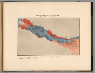
1870 Plate 2. Geological Map of the Washoe Mi … Geologic Atlas Plate 2. Geological Map of the Washoe Mi … |

1870 Plate 3. Horizontal Map Gold Hill Mines … Geologic Atlas Plate 3. Horizontal Map Gold Hill Mines … |

1870 Plate 4. Horizontal Map Virginia Mines W … Geologic Atlas Plate 4. Horizontal Map Virginia Mines W … |
1870 Plate 13. Geological Map of the Toyabe ( … Geologic Atlas Plate 13. Geological Map of the Toyabe ( … |

1870 Plate 14. Geological Map of the White Pi … Geologic Atlas Plate 14. Geological Map of the White Pi … |

1870 Plate 5. Horizontal Map North Virginia M … Geologic Atlas Plate 5. Horizontal Map North Virginia M … |

1887 Anthony, Harper Co. State Atlas Anthony, Harper Co. L.H. Everts & Co., p … |

1887 Wellington, Beaumont, Brainard and Bento … State Atlas Wellington, Sumner Co. (with) Beaumont . … |

1887 Coffey Co., Kansas. State Atlas Coffey Co., Kansas. L.H. Everts & Co., p … |

1838 Arkansas. National Atlas Arkansas. Entered ... 1838, by T.G. Brad … |

1887 City of Burlington, Coffee County. State Atlas City of Burlington, Coffee County. L.H. … |

1887 Riley Co. and Randolph, Cleburne, Leonda … State Atlas Riley Co., Kansas. (with) Randolph ... ( … |

1887 Lebo, LeRoy, and Strawn. State Atlas Lebo, Coffee Co. (with) Le Roy, Coffee C … |

1887 Franklin County. State Atlas Franklin County. (L.H. Everts & Co., pub … |
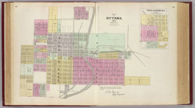
1887 Ottawa City, Williamsburg State Atlas Map of Ottawa City, Franklin Co. (with) … |

1887 Pomona, Richmond, Ferguson and Peoria. State Atlas Pomona, Franklin Co. (with) Richmond ... … |

1838 Missouri. National Atlas Missouri. Entered ... 1838, by T.G. Brad … |

1887 Wellsville, Emmerson, Reedsburg, Princet … State Atlas Wellsville ... (with) Emmerson ... (with … |

1887 Barber Co. and Hazelton, Kansas. State Atlas Barber Co., Kansas. (with) Hazelton ... … |

1887 City of Medicine Lodge, Kansas. State Atlas City of Medicine Lodge ... Barber Co., K … |

1887 New Kiowa, Sun City, Stanley, Holliday, … State Atlas New Kiowa ... Barber Co. (with) Sun City … |

1887 Johnson Co., Kansas. State Atlas Johnson Co., Kansas. L.H. Everts & Co., … |

1887 Spring Hill, Edgerton, Ocheltree, Gardne … State Atlas Spring Hill ... (with) Edgerton ... (wit … |

1887 Olathe, Shawnee and De Soto, Johnson Co. … State Atlas Olathe, Johnson Co., Kan. (with) Shawnee … |

1887 Merriam, Altamont, Montana, Mound Valley … State Atlas Merriam ... Johnson Co. (with) Altamont … |

1838 Iowa and Wisconsin. National Atlas Iowa and Wisconsin. (inset) Part of Wisc … |

1887 Labette Co., Kansas. State Atlas Labette Co., Kansas. L.H. Everts & Co., … |

1887 Chetopa, Dennis, Piqua, Labette City. State Atlas Chetopa, La Bette Co. (with) Dennis, Lab … |

1887 Parsons, Labette Co. State Atlas Parsons, Labette Co. L.H. Everts & Co., … |

1887 Woodson Co., Kansas. State Atlas Woodson Co., Kansas. L.H. Everts & Co., … |