Browse All

1979 Average Amount of Precipitation mm, June … World Atlas Average Amount of Precipitation mm, June … |

1979 Average Amount of Precipitation mm, July … World Atlas Average Amount of Precipitation mm, July … |

1887 Sabetha, Centralia and Taylor Rapids, Ka … State Atlas Sabetha, ... Nemaha Co., Kan. (with) Cen … |

1979 Average Amount of Precipitation mm, Augu … World Atlas Average Amount of Precipitation mm, Augu … |

1979 Average Amount of Precipitation mm, Sept … World Atlas Average Amount of Precipitation mm, Sept … |

1979 Average Amount of Precipitation mm, Octo … World Atlas Average Amount of Precipitation mm, Octo … |

1979 Average Amount of Precipitation mm, Nove … World Atlas Average Amount of Precipitation mm, Nove … |

1979 Average Amount of Precipitation mm, Dece … World Atlas Average Amount of Precipitation mm, Dece … |

1979 Meteorological Stations Used for the Pre … World Atlas Meteorological Stations Used for the Pre … |

1979 Average Amount of Precipitation mm, Year … World Atlas Average Amount of Precipitation mm, Year … |

1979 Average Amount of Precipitation mm, Year … World Atlas Average Amount of Precipitation mm, Year … |

1979 Average Amount of Precipitation mm, Year … World Atlas Average Amount of Precipitation mm, Year … |

1887 Seneca, Oneida, Goffs, Baileyville. State Atlas Seneca, Nemaha County. (with) Oneida ... … |

1887 Nemaha Co., Wetmore and Corning, Kansas. State Atlas Nemaha Co., Kansas. (with) Wetmore .... … |

1878 Map of the Vicinity of the North West Po … Exploration Book United States Northern Boundary Commissi … |

1887 Reece, Fall River, Hamilton, Neal, Clima … State Atlas Reece ... (with) Fall River ... (with) H … |

1878 Sketch Showing Triangulation of Chief Mo … Exploration Book Sketch Showing Triangulation of Chief Mo … |

1878 U.S. Coast Survey Chart 1875. Declinatio … Exploration Book General Authority U.S. Coast Survey Char … |

1878 Profile. Reconnaissance Series. (Lake of … Exploration Book Profile. Reconnaissance Series. (Lake of … |

1878 No. I, Reconnaissance Map. (Fort Shaw to … Exploration Book United States Northern Boundary Commissi … |

1878 No. II, Reconnaissance Map. (Old Fort Br … Exploration Book United States Northern Boundary Commissi … |

1878 No. III, Reconnaissance Map. (Big Muddy … Exploration Book United States Northern Boundary Commissi … |

1878 No. IV, Reconnaissance Map. (Mouse River … Exploration Book United States Northern Boundary Commissi … |

1878 No. V, Reconnaissance Map. (Pembina Moun … Exploration Book United States Northern Boundary Commissi … |

1878 No. VI, Reconnaissance Map. (Lake of the … Exploration Book United States Northern Boundary Commissi … |

1887 Madison, Waverly, Bacheller, New Milford … State Atlas Madison ... Greenwood Co. (with) Waverly … |

1887 Davis Co., Kansas. State Atlas Davis Co., Kansas. L.H. Everts & Co., pu … |

1865 The World in Hemispheres. With others Pr … World Atlas The World in Hemispheres. With others Pr … |

1865 Map of the World in Mercator projection World Atlas Map of the World in Mercator projection. … |

1865 Map of North America World Atlas Map of North America. Showing its politi … |

1865 County map of Nova Scotia, New Brounswic … World Atlas County map of Nova Scotia, New Brounswic … |

1887 Neosho Co., Kansas. State Atlas Neosho Co., Kansas. L.H. Everts & Co., p … |

1865 Map of Canada East in Counties World Atlas Map of Canada East in Counties. Entered … |

1865 Map of Canada West in Counties World Atlas Map of Canada West in Counties. Entered … |

1865 Map of the United States, and Territorie … World Atlas Map of the United States, and Territorie … |
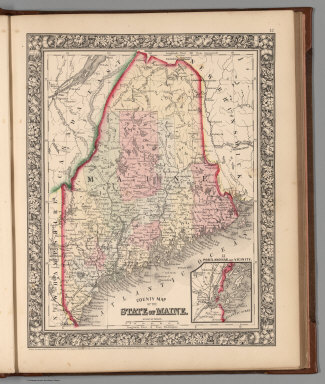
1865 County map of the State of Maine World Atlas County map of the State of Maine. Entere … |

1887 Chanute, Shaw, Morehead. State Atlas Chanute ... (with) Shaw ... (with) Moreh … |

1865 New Hampshire and Vermont World Atlas New Hampshire and Vermont. Drawn and Eng … |

1865 County map of Massachusetts, Connecticut … World Atlas County map of Massachusetts, Connecticut … |

1865 County map of the State of New York, New … World Atlas County map of the State of New York, New … |

1865 Plan of New York &c. World Atlas Plan of New York &c. Entered ... 1860 by … |

1865 Plan of Boston World Atlas Plan of Boston. Entered ... 1860 by S. A … |

1865 County map of the State of Pennsylvania World Atlas County map of the State of Pennsylvania. … |

1865 Plan of Philadelphia World Atlas Plan of Philadelphia. Entered ... 1865 b … |

1865 New Jersey, Maryland, Delaware World Atlas County map of New Jersey. (Scale: 1:1,10 … |

1865 Plan of Baltimore World Atlas Plan of Baltimore. Entered ... 1860 by S … |

1865 Plan of the City of Washington. The Capi … World Atlas Plan of the City of Washington. The Capi … |

1865 County map of Virginia and West Virginia World Atlas County map of Virginia and West Virginia … |

1887 Osage Mission, Galesburg, Earlton. State Atlas Osage Mission ... (with) Galesburg ... ( … |

1865 County map of Kentucky and Tennessee World Atlas County map of Kentucky, and Tennessee. E … |