Who What Where WhenREMOVEWHO
WHEN
|
Author
[Paullin, Charles O., Wright, John K.]
Full Title
Plate 48. Lands. System of Survey of Public Lands under Act of 1796. Plan of Lystra, in Nelson County, Kentucky (Facsimile).
Publisher
[Carnegie Institution of Washington, American Geographical Society of New York]
Author
[Paullin, Charles O., Wright, John K.]
Full Title
Plate 49. Lands. Territorial Claims and Limits on the Northwest Coast of America, 1790 - 1846.
Publisher
[Carnegie Institution of Washington, American Geographical Society of New York]
Author
[Paullin, Charles O., Wright, John K.]
Full Title
Plate 50. Lands. Lands Granted to States for Educational and Other Purposes, 1785 - 1919. Land of the Ohio Company about 1787. George Rogers Clark Grant about 1785. Lands Granted in 1828 for Construction of Columbus and Sandusky Turnpike (Facsimiles).
Publisher
[Carnegie Institution of Washington, American Geographical Society of New York]
Author
[Paullin, Charles O., Wright, John K.]
Full Title
Plate 51. Lands. Survey of Fairfax Lands, 1736-1737. Grant to Washington for Military Services, 1774 (Facsimiles).
Publisher
[Carnegie Institution of Washington, American Geographical Society of New York]
Author
[Paullin, Charles O., Wright, John K.]
Full Title
Plate 52. Lands. A French Settlement, Kaskaskia, Illinois ... Plan of Settlement 1807; Specimen of Common Fields about 1809 (Facsimiles).
Publisher
[Carnegie Institution of Washington, American Geographical Society of New York]
Author
[Paullin, Charles O., Wright, John K.]
Full Title
Plate 53. Lands. Southern Plantation, Mount Vernon, Virginia: Mansion House Grounds, 1787; The Farm, 1793. A Colonial Manor, Livingston Manor, New York: The Manor, 1714; Distribution of Tenants, 1798 (Facsimiles).
Publisher
[Carnegie Institution of Washington, American Geographical Society of New York]
Author
[Paullin, Charles O., Wright, John K.]
Full Title
Plate 54. Lands. A Modern City, Springfield, Illinois, 1915 (Facsimile).
Publisher
[Carnegie Institution of Washington, American Geographical Society of New York]
Author
[Paullin, Charles O., Wright, John K.]
Full Title
Plate 55. Lands. A Modern City, Springfield, Illinois, 1914: Ward Map; Specimen Blocks. Large Land Holdings in Southwestern Washington, 1914. Donation Lands under Act of 1850 (Facsimiles).
Publisher
[Carnegie Institution of Washington, American Geographical Society of New York]
Author
[Paullin, Charles O., Wright, John K.]
Full Title
Plate 56. Lands. A Western Town: Carroll, Nebraska, 1918. A Western Township Pilot Knob, Harper County, Kansas, 1919. Specimen Private Land Claims, 1835. Federal Land Grants for the Construction of Railroads and Wagon Roads, 1823-1871. Oil Land Withdrawals in California, 1915 (Facsimiles).
Publisher
[Carnegie Institution of Washington, American Geographical Society of New York]
Author
Faden, William, 1750?-1836
Full Title
Nouvelle carte de la Suisse dans laquelle sont exactement distingues les treize cantons, leurs allies, et leurs sujets. Dressee sur les memoires les plus corrects et assujettie aux observations astronomiques. a Londre, chez W. Faden, Charing Cross, 1799. Printed for W. Faden ... as the Act directs.
Publisher
William Faden
Author
[Paullin, Charles O., Wright, John K.]
Full Title
Plate 57. Public Lands. Public Lands of United States, 1790. Public Lands of United States, 1810.
Publisher
[Carnegie Institution of Washington, American Geographical Society of New York]
Author
[Paullin, Charles O., Wright, John K.]
Full Title
Plate 58. Public Lands. Public Lands of United States, 1830. Public Lands of United States, 1850. Public Lands of United States, 1870. Public Lands of United States, 1890.
Publisher
[Carnegie Institution of Washington, American Geographical Society of New York]
Author
[Paullin, Charles O., Wright, John K.]
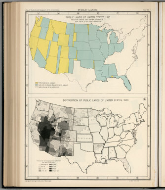
Full Title
Plate 59. Public Lands. Public Lands of United States, 1910. Distribution of Public Lands of United States, 1929.
Publisher
[Carnegie Institution of Washington, American Geographical Society of New York]
Author
[Paullin, Charles O., Wright, John K.]
Full Title
Plate 60. Settlement and Population, 1660-1790. Settled Areas and Population, 1660. Settled Areas and Population, 1770. Settled Areas, 1760, and Population, 1750. Settled Areas and Population, 1775. Settled Areas and Population, 1790.
Publisher
[Carnegie Institution of Washington, American Geographical Society of New York]
Author
[Paullin, Charles O., Wright, John K.]
Full Title
Plate 61. Colonial Towns, States, Territories, and Cities. Colonial Towns, 1650. Colonial Towns, 1700. Colonial Towns, 1750. Colonial Towns, 1775. States, Territories and Cities, 1790. States, Territories and Cities, 1800. States, Territories and Cities, 1810.
Publisher
[Carnegie Institution of Washington, American Geographical Society of New York]
Author
[Paullin, Charles O., Wright, John K.]
Full Title
Plate 62. States, Territories and Cities. States, Territories and Cities, 1820. States, Territories and Cities, 1830.
Publisher
[Carnegie Institution of Washington, American Geographical Society of New York]
Author
[Paullin, Charles O., Wright, John K.]
Full Title
Plate 63. States, Territories and Cities. States, Territories and Cities, 1840. States, Territories and Cities, 1850.
Publisher
[Carnegie Institution of Washington, American Geographical Society of New York]
Author
[Paullin, Charles O., Wright, John K.]
Full Title
Plate 64. States, Territories and Cities. States, Territories and Cities, 1860. States, Territories and Cities, 1870. States and Territories (Additional Maps 1845-1868). States, Territories and Cities, 1880.
Publisher
[Carnegie Institution of Washington, American Geographical Society of New York]
Author
[Academie royale des sciences et belles lettres, Berlin, Germany, Faden, William, 1750?-1836]
Full Title
A new map of the German Empire, and the neighbouring states with their principal post roads, originally published by the Royal Academy of Berlin. Engraved with several additions and improvements by William Faden, Geographer to the King. London, published according to Act of Parliament June the 24th, 1788 by William Faden, corner of St. Martins Lane, Charing Cross.
Publisher
William Faden
Author
[Paullin, Charles O., Wright, John K.]
Full Title
Plate 65. States, Territories and Cities. States, Territories and Cities, 1890. States, Territories and Cities, 1900.
Publisher
[Carnegie Institution of Washington, American Geographical Society of New York]
Author
[Paullin, Charles O., Wright, John K.]
Full Title
Plate 66. States, Territories and Cities. States, Territories and Cities, 1910. States, Territories and Cities, 1920.
Publisher
[Carnegie Institution of Washington, American Geographical Society of New York]
Author
[Paullin, Charles O., Wright, John K.]
Full Title
Plate 67. States and Cities: Population. States and Cities, 1930. Slaves, 1790. Slaves, 1800. Slaves, 1810. Slaves, 1820. Slaves, 1830. Slaves, 1840.
Publisher
[Carnegie Institution of Washington, American Geographical Society of New York]
Author
[Paullin, Charles O., Wright, John K.]
Full Title
Plate 68. Population. Slaves, 1850. Slaves, 1860. Free Negroes, 1810.
Publisher
[Carnegie Institution of Washington, American Geographical Society of New York]
Author
[Paullin, Charles O., Wright, John K.]
Full Title
Plate 69. Population. Free Negroes, 1860. Colored Population, 1880.
Publisher
[Carnegie Institution of Washington, American Geographical Society of New York]
Author
[Paullin, Charles O., Wright, John K.]
Full Title
Plate 70. Population: Emigration to the United States. Colored Population, 1900. Colored Population, 1930. Sources of Emigration to the United States (by decade),
Publisher
[Carnegie Institution of Washington, American Geographical Society of New York]
Author
[Paullin, Charles O., Wright, John K.]
Full Title
Plate 71. Population. Foreign-Born Population, 1860. Foreign-Born Population, 1880.
Publisher
[Carnegie Institution of Washington, American Geographical Society of New York]
Author
[Paullin, Charles O., Wright, John K.]
Full Title
Plate 72. Population. Foreign-Born Population, 1900. Foreign-Born White Population, 1930.
Publisher
[Carnegie Institution of Washington, American Geographical Society of New York]
Author
[Paullin, Charles O., Wright, John K.]
Full Title
Plate 73. Population. Foreign-Born Population, German, 1880. Foreign-Born Population, German, 1900. Foreign-Born Population, German, 1930. Foreign-Born Population, Irish, 1880.
Publisher
[Carnegie Institution of Washington, American Geographical Society of New York]
Author
[Paullin, Charles O., Wright, John K.]
Full Title
Plate 74. Population. Foreign-Born Population, Irish, 1900. Foreign-Born Population, Irish, 1930.
Publisher
[Carnegie Institution of Washington, American Geographical Society of New York]
Author
[Academie royale des sciences et belles lettres, Berlin, Germany, Faden, William, 1750?-1836]
Full Title
A new map of the German Empire, and the neighbouring states with their principal post roads, originally published by the Royal Academy of Berlin. Engraved with several additions and improvements by William Faden, Geographer to the King. London, published according to Act of Parliament June the 24th, 1788 by William Faden, corner of St. Martins Lane, Charing Cross.
Publisher
William Faden
Author
[Paullin, Charles O., Wright, John K.]
Full Title
Plate 75. Population. Foreign-Born Population, Swedish and Norwegian, 1880. Foreign-Born Population, Swedish and Norwegian, 1900.
Publisher
[Carnegie Institution of Washington, American Geographical Society of New York]
Author
[Paullin, Charles O., Wright, John K.]
Full Title
Plate 76. Population. Foreign-Born Population, Swedish and Norwegian, 1790. Density of Population, 1800. Density of Population, 1810. Density of Population, 1820. Density of Population, 1830. Density of Population, 1840.
Publisher
[Carnegie Institution of Washington, American Geographical Society of New York]
Author
[Paullin, Charles O., Wright, John K.]
Full Title
Plate 77. Population. Density of Population, 1850. Density of Population, 1860. Density of Population, 1870.
Publisher
[Carnegie Institution of Washington, American Geographical Society of New York]
Author
[Paullin, Charles O., Wright, John K.]
Full Title
Plate 78. Population. Density of Population, 1880. Density of Population, 1890.
Publisher
[Carnegie Institution of Washington, American Geographical Society of New York]
Author
[Paullin, Charles O., Wright, John K.]
Full Title
Plate 79. Density of Population. Density of Population, 1900. Density of Population, 1910. Density of Population, 1920. Density of Population, 1930.
Publisher
[Carnegie Institution of Washington, American Geographical Society of New York]
Author
[Paullin, Charles O., Wright, John K.]
Full Title
Plate 80. Population: Colleges and Universities. Centers of Population. Colleges and Universities, 1775. Colleges and Universities, 1800. Colleges and Universities, 1830.
Publisher
[Carnegie Institution of Washington, American Geographical Society of New York]
Author
[Paullin, Charles O., Wright, John K.]
Full Title
Plate 81. Colleges and Universities. Colleges and Universities, 1860. Colleges and Universities, 1890.
Publisher
[Carnegie Institution of Washington, American Geographical Society of New York]
Author
[Paullin, Charles O., Wright, John K.]
Full Title
Plate 82. Churches. Congregationalist, 1775-1776. Presbyterian, 1775-1776. Protestant-Episcopal, 1775-1776. Baptist, 1775-1776. Friends, 1775-1776. German Reformed, 1776-1776. Lutheran, 1775-1776. Dutch Reformed, 1775-1776. Methodist, 1775-1776. Catholic, 1775-1776. Minor Denominations, 1775-1776. Minor Denominations, 1775-1776.
Publisher
[Carnegie Institution of Washington, American Geographical Society of New York]
Author
[Paullin, Charles O., Wright, John K.]
Full Title
Plate 83. Churches. Methodist, 1860. Baptist, 1860.
Publisher
[Carnegie Institution of Washington, American Geographical Society of New York]
Author
[Faden, William, 1750?-1836, Jefferys, Thomas]
Full Title
A new map of the King of Great Britain's dominions in Germany, or the Electorate of Brunswick-Luneburg and its dependencies. By Thomas Jefferys, Geographer to his Majesty with various improvements and emendations. London, published by W. Faden, Geographer to the King, Charing Cross, June 1st, 1789.
Publisher
William Faden
Author
[Paullin, Charles O., Wright, John K.]
Full Title
Plate 84. Churches. Congregational, 1860. Protestant-Episcopal, 1860. Lutheran, 1860. "Christian," 1860. Reformed, 1860. Friends, 1860. Presbyterian, 1860.
Publisher
[Carnegie Institution of Washington, American Geographical Society of New York]
Author
[Paullin, Charles O., Wright, John K.]
Full Title
Plate 85. Churches. Catholic, 1860. Methodist, 1890.
Publisher
[Carnegie Institution of Washington, American Geographical Society of New York]
Author
[Paullin, Charles O., Wright, John K.]
Full Title
Plate 86. Churches. Baptist, 1890. Presbyterian, 1890.
Publisher
[Carnegie Institution of Washington, American Geographical Society of New York]
Author
[Paullin, Charles O., Wright, John K.]
Full Title
Plate 87. Churches. Catholic, 1890. Congregational, 1890. Protestant - Episcopal, 1890. Lutheran, 1890.
Publisher
[Carnegie Institution of Washington, American Geographical Society of New York]
Author
[Paullin, Charles O., Wright, John K.]
Full Title
Plate 88. Churches. Disciples of Christ, 1890. Reformed, 1890.
Publisher
[Carnegie Institution of Washington, American Geographical Society of New York]
Author
[Paullin, Charles O., Wright, John K.]
Full Title
Plate 89. Negotiation for Peace, 1779 - 1783. Negotiations for Peace (Base, Mitchell's Map of North America, 1755, second edition reduced size).
Publisher
[Carnegie Institution of Washington, American Geographical Society of New York]
Author
[Paullin, Charles O., Wright, John K.]
Full Title
Plate 90. Negotiation for Peace, 1779 - 1783. Negotiations for Peace (Northeast Section) (Base, Mitchell's Map of North America, 1755, second edition, reduced size).
Publisher
[Carnegie Institution of Washington, American Geographical Society of New York]
Author
[Paullin, Charles O., Wright, John K.]
Full Title
Plate 91. International Boundary Disputes. The Northwest Angle of Nova Scotia and the Highlands. Isle Royal to Lake of the Woods. St. Croix River.
Publisher
[Carnegie Institution of Washington, American Geographical Society of New York]
Author
[Paullin, Charles O., Wright, John K.]
Full Title
Plate 92. International Boundary Disputes. Islands in the Bay of Fundy. Definition of Boundary in Bay of Fundy.
Publisher
[Carnegie Institution of Washington, American Geographical Society of New York]
Author
Faden, William, 1750?-1836
Full Title
A map of the Kingdom of Poland and Grand Dutchy of Lithuania including Samogitia and Curland, divided according to their dismemberments, with the Kingdom of Prussia. (with) Warszawa, Warsaw. By Willm. Faden, Geographer to the King, M DCC XCIX. London, published by W. Faden, Geographer to the King & to H.R.H. the Prince of Wales, Charing Cross, April 2d, 1799. 2d edition.
Publisher
William Faden
|