Who What Where WhenREMOVEWHO
WHEN
|
Author
Andreas, A. T. (Alfred Theodore), 1839-1900
Full Title
Adams County.
Publisher
Andreas, Lyter & Co.
Author
[Cook, George Hammell, 1818-1889, Geological Survey of New Jersey, Smock, John Conover, Vermeule, C. C. (Cornelius Clarkson), 1858-1950]
Full Title
A topographical map of the Central Highlands including all of Morris County west of Boonton and Sussex County south and east of Newton. George H. Cook, State Geologist, John C. Smock, assistant geologist, C.C.Vermeule, topographer. 1884. Geological Survey of New Jersey. Atlas sheet no. 3, Central Highlands. Julius Bien & Co., Lith., N.Y. (1888)
Publisher
Julius Bien
Author
[Cook, George Hammell, 1818-1889, Geological Survey of New Jersey, Smock, John Conover, Vermeule, C. C. (Cornelius Clarkson), 1858-1950]
Full Title
A topographical map of the Northeastern Highlands including the country lying between Deckertown, Dover, Paterson and Suffern. George H. Cook, State Geologist, John C. Smock, assistant geologist, C.C.Vermeule, topographer. 1884. Geological Survey of New Jersey. Atlas sheet no. 4, Northeastern Highlands. Julius Bien & Co., Lith., N.Y. (1888)
Publisher
Julius Bien
Author
[Cook, George Hammell, 1818-1889, Geological Survey of New Jersey, Vermeule, C. C. (Cornelius Clarkson), 1858-1950]
Full Title
A topographical map of the vicinity of Flemington from Somerville and Princeton westward to the Delaware. George H. Cook, State Geologist, C.C.Vermeule, topographer. 1887. Geological Survey of New Jersey. Atlas sheet no. 5, southwestern red sandstone. Julius Bien & Co., Lith. (1888)
Publisher
Julius Bien
Author
[Cook, George Hammell, 1818-1889, Geological Survey of New Jersey, Smock, John Conover, Vermeule, C. C. (Cornelius Clarkson), 1858-1950]
Full Title
A topographical map of the valley of the Passaic with the country eastward to Newark and southward to the Raritan River. George H. Cook, State Geologist, John C. Smock, assistant geologist, C.C.Vermeule, topographer. 1885. Geological Survey of New Jersey. Atlas sheet no. 6, central red sandstone. Julius Bien & Co., Lith. (1888)
Publisher
Julius Bien
Author
[Cook, George Hammell, 1818-1889, Geological Survey of New Jersey, Smock, John Conover, Vermeule, C. C. (Cornelius Clarkson), 1858-1950]
Full Title
A topographical map of the counties of Bergen, Hudson and Essex, with parts of Passaic and Union. George H. Cook, State Geologist, John C. Smock, assistant geologist, C.C.Vermeule, topographer. 1884. Geological Survey of New Jersey. Atlas sheet no. 7, northeastern red sandstone. Julius Bien & Co., Lith., N.Y. (1888)
Publisher
Julius Bien
Author
[Cook, George Hammell, 1818-1889, Geological Survey of New Jersey, Vermeule, C. C. (Cornelius Clarkson), 1858-1950]
Full Title
A topographical map of the vicinity of Trenton, New Brunswick and Bordentown. George H. Cook, State Geologist, C.C.Vermeule, topographer. 1887. Geological Survey of New Jersey. Atlas sheet no. 8, Trenton. Julius Bien & Co., Lith. (1888)
Publisher
Julius Bien
Author
[Cook, George Hammell, 1818-1889, Geological Survey of New Jersey, Vermeule, C. C. (Cornelius Clarkson), 1858-1950]
Full Title
A topographical map of the Monmouth shore with the interior from Metuchen to Lakewood. George H. Cook, State Geologist, C.C.Vermeule, topographer. 1886. Geological Survey of New Jersey. Atlas sheet no. 9, Monmouth shore. Julius Bien & Co., Lith. (1888)
Publisher
Julius Bien
Author
[Cook, George Hammell, 1818-1889, Geological Survey of New Jersey, Vermeule, C. C. (Cornelius Clarkson), 1858-1950]
Full Title
A topographical map of the vicinity of Salem from Woodbury and Bridgeton westward to the Delaware River. George H. Cook, State Geologist, C.C.Vermeule, topographer. 1887. Geological Survey of New Jersey. Atlas sheet no. 10, Lower Delaware. Julius Bien & Co., Lith. (1888)
Publisher
Julius Bien
Author
[Cook, George Hammell, 1818-1889, Geological Survey of New Jersey, Vermeule, C. C. (Cornelius Clarkson), 1858-1950]
Full Title
A topographical map of the vicinity of Camden to Burlington, Winslow, Elmer and Swedesboro. George H. Cook, State Geologist, C.C.Vermeule, topographer. 1887. Geological Survey of New Jersey. Atlas sheet no. 11, Camden. Julius Bien & Co., Lith. (1888)
Publisher
Julius Bien
Author
Andreas, A. T. (Alfred Theodore), 1839-1900
Full Title
Map of Northeast Township.
Publisher
Andreas, Lyter & Co.
Author
Andreas, A. T. (Alfred Theodore), 1839-1900
Full Title
Map of Houston Township.
Publisher
Andreas, Lyter & Co.
Author
Andreas, A. T. (Alfred Theodore), 1839-1900
Full Title
Map of Keene Township.
Publisher
Andreas, Lyter & Co.
Author
Andreas, A. T. (Alfred Theodore), 1839-1900
Full Title
Map of Lima Township.
Publisher
Andreas, Lyter & Co.
Author
Andreas, A. T. (Alfred Theodore), 1839-1900
Full Title
Map of Ursa Township. Map of Mendon Township.
Publisher
Andreas, Lyter & Co.
Author
Andreas, A. T. (Alfred Theodore), 1839-1900
Full Title
Map of Honey Creek Township.
Publisher
Andreas, Lyter & Co.
Author
[Cook, George Hammell, 1818-1889, Geological Survey of New Jersey, Vermeule, C. C. (Cornelius Clarkson), 1858-1950]
Full Title
A topographical map of the vicinity of Mount Holly from Bordentown southward to Winslow and Woodmansie. George H. Cook, State Geologist, C.C.Vermeule, topographer. 1887. Geological Survey of New Jersey. Atlas sheet no. 12, Mount Holly. Julius Bien & Co., Lith. (1888)
Publisher
Julius Bien
Author
Andreas, A. T. (Alfred Theodore), 1839-1900
Full Title
Map of Camp Point Township.
Publisher
Andreas, Lyter & Co.
Author
Andreas, A. T. (Alfred Theodore), 1839-1900
Full Title
Map of Camp Point, Camp Point Township. (View) Residence of Origen Wallace.
Publisher
Andreas, Lyter & Co.
Author
Andreas, A. T. (Alfred Theodore), 1839-1900
Full Title
Map of Clayton Township.
Publisher
Andreas, Lyter & Co.
Author
Andreas, A. T. (Alfred Theodore), 1839-1900
Full Title
Map of Clayton. Map of Loraine. Map of Mendon. Map of New Liberty (Liberty). Map of Marcelline.
Publisher
Andreas, Lyter & Co.
Author
[Cook, George Hammell, 1818-1889, Geological Survey of New Jersey, Vermeule, C. C. (Cornelius Clarkson), 1858-1950]
Full Title
A topographical map of the vicinity of Barnegat Bay with the greater part of Ocean County. George H. Cook, State Geologist, C.C.Vermeule, topographer. 1886. Geological Survey of New Jersey. Atlas sheet no. 13, Barnegat. Julius Bien & Co., Lith. (1888)
Publisher
Julius Bien
Author
Andreas, A. T. (Alfred Theodore), 1839-1900
Full Title
Map of Concord Township.
Publisher
Andreas, Lyter & Co.
Author
Andreas, A. T. (Alfred Theodore), 1839-1900
Full Title
Map of Columbus Township.
Publisher
Andreas, Lyter & Co.
Author
Andreas, A. T. (Alfred Theodore), 1839-1900
Full Title
Map of Burton. Map of Columbus. Map of Laprairie.
Publisher
Andreas, Lyter & Co.
Author
Andreas, A. T. (Alfred Theodore), 1839-1900
Full Title
Map of Gilmer Township.
Publisher
Andreas, Lyter & Co.
Author
[Cook, George Hammell, 1818-1889, Geological Survey of New Jersey, Vermeule, C. C. (Cornelius Clarkson), 1858-1950]
Full Title
A topographical map of the vicinity of Bridgeton from Alloway, Elmer and Newfield southward to the Delaware Bay shore. George H. Cook, State Geologist, C.C.Vermeule, topographer. 1887. Geological Survey of New Jersey. Atlas sheet no. 14, Delaware Bay. Julius Bien & Co., Lith. (1888)
Publisher
Julius Bien
Author
Andreas, A. T. (Alfred Theodore), 1839-1900
Full Title
Map of Ellington Township. (inset) Map of Bloomfield.
Publisher
Andreas, Lyter & Co.
Author
Andreas, A. T. (Alfred Theodore), 1839-1900
Full Title
Map of Quincy.
Publisher
Andreas, Lyter & Co.
Author
Andreas, A. T. (Alfred Theodore), 1839-1900
Full Title
Quincy Original and Parts of Its Additions.
Publisher
Andreas, Lyter & Co.
Author
Andreas, A. T. (Alfred Theodore), 1839-1900
Full Title
Map of Melrose Township. Map of Beverly. Map of Kingston.
Publisher
Andreas, Lyter & Co.
Author
Andreas, A. T. (Alfred Theodore), 1839-1900
Full Title
Map of Burton Township.
Publisher
Andreas, Lyter & Co.
Author
[Cook, George Hammell, 1818-1889, Geological Survey of New Jersey, Vermeule, C. C. (Cornelius Clarkson), 1858-1950]
Full Title
A topographical map of the southern interior from Millville to Atco and Egg Harbor City. George H. Cook, State Geologist, C.C.Vermeule, topographer. 1887. Geological Survey of New Jersey. Atlas sheet no. 15, southern interior. Julius Bien & Co., Lith. (1888)
Publisher
Julius Bien
Author
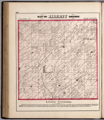
Andreas, A. T. (Alfred Theodore), 1839-1900
Full Title
(View) Map of Liberty Township.
Publisher
Andreas, Lyter & Co.
Author
Andreas, A. T. (Alfred Theodore), 1839-1900
Full Title
Map of McKee Township.
Publisher
Andreas, Lyter & Co.
Author
Andreas, A. T. (Alfred Theodore), 1839-1900
Full Title
Map of Beverly Township.
Publisher
Andreas, Lyter & Co.
Author
Andreas, A. T. (Alfred Theodore), 1839-1900
Full Title
Map of Richfield Township.
Publisher
Andreas, Lyter & Co.
Author
Andreas, A. T. (Alfred Theodore), 1839-1900
Full Title
Map of Payson Township.
Publisher
Andreas, Lyter & Co.
Author
[Cook, George Hammell, 1818-1889, Geological Survey of New Jersey, Smock, John Conover, Vermeule, C. C. (Cornelius Clarkson), 1858-1950]
Full Title
A topographical map of Egg Harbor and vicinity including the Atlantic shore from Barnegat to Great Egg Harbor. George H. Cook, State Geologist, John C. Smock, assistant geologist, C.C.Vermeule, topographer. 1885. Geological Survey of New Jersey. Atlas sheet no. 16, Egg Harbor. Julius Bien & Co., Lith. (1888)
Publisher
Julius Bien
Author
Andreas, A. T. (Alfred Theodore), 1839-1900
Full Title
Map of Payson. Map of Keokuk Junction. Map of Fowler.
Publisher
Andreas, Lyter & Co.
Author
Andreas, A. T. (Alfred Theodore), 1839-1900
Full Title
Map of Coatsburg. Map of Houston. Map of Paloma. Map of Lima. (View) Residence of E. Seymour.
Publisher
Andreas, Lyter & Co.
Author
[Cook, George Hammell, 1818-1889, Geological Survey of New Jersey, Vermeule, C. C. (Cornelius Clarkson), 1858-1950]
Full Title
A topographical map of the peninsula of Cape Bay with the country westward to Maurice River. George H. Cook, State Geologist, C.C.Vermeule, topographer. 1886. Geological Survey of New Jersey. Atlas sheet no. 17, Cape May. Julius Bien & Co., Lith. (1888)
Publisher
Julius Bien
Author
Andreas, A. T. (Alfred Theodore), 1839-1900
Full Title
Map of Fall Creek Township. Map of Millville. Map of Newtown, Map of Planeville.
Publisher
Andreas, Lyter & Co.
Author
[Morse, Sidney E., Breese, S.]
Full Title
A map of the Indian Territory, northern Texas and New Mexico : Showing the great western prairies by Josiah Gregg. Entered ... 1844 by Sidney E. Morse and Samuel Breese ... New York. (New York: Published by Harper & Brothers, 1845). (to accompany) Morse's Cerographic Maps. 1845. No. I.
Publisher
Harper and Brothers
Author
[Morse, Sidney E., Breese, Samuel]
Full Title
Michigan. Entered ... 1844 by Sidney E. Morse and Samuel Breese ... New York. (New York: Published by Harper & Brothers, 1845). (to accompany) Morse's Cerographic Maps. No. I.
Publisher
Harper and Brothers
Author
[Morse, Sidney E., Breese, Samuel]
Full Title
Arkansas. Entered ... 1844 by Sidney E. Morse and Samuel Breese ... New York. (New York: Published by Harper & Brothers, 1845). (to accompany) Morse's Cerographic Maps. No. I.
Publisher
Harper and Brothers
Author
[Morse, Sidney E., Breese, Samuel]
Full Title
Wisconsin Southern part 1845. Entered ... 1844 by Sidney E. Morse and Samuel Breese ... New York. (New York: Published by Harper & Brothers, 1845). (to accompany) Morse's Cerographic Maps. No. I.
Publisher
Harper and Brothers
Full Title
Westchester County and surroundings. Copyrighted by Julius Bien & Co. 1890. (1893)
Publisher
Julius Bien & Co.
Author
[Morse, Sidney E., Breese, Samuel]
Full Title
Ohio. (New York: Published by Harper & Brothers, 1845). (to accompany) Morse's Cerographic Maps. No. II.
Publisher
Harper and Brothers
Author
[Morse, Sidney E., Breese, Samuel]
Full Title
Missouri. Entered ... 1844 by Sidney E. Morse and Samuel Breese ... New York. (New York: Published by Harper & Brothers, 1845). (to accompany) Morse's Cerographic Maps. No. II.
Publisher
Harper and Brothers
|